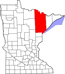
Mahnomen, St. Louis County, Minnesota
| Mahnomen, Minnesota | |
|---|---|
| Census-designated place (CDP) and Unincorporated community | |
 Mahnomen, Minnesota Location of the community of Mahnomen within Brevator Township, Saint Louis County | |
| Coordinates: 46°46′23″N 92°32′30″W / 46.77306°N 92.54167°WCoordinates: 46°46′23″N 92°32′30″W / 46.77306°N 92.54167°W | |
| Country | United States |
| State | Minnesota |
| County | Saint Louis |
| Township | Brevator Township |
| Area[1] | |
| • Total | 1.261 sq mi (3.27 km2) |
| • Land | 1.261 sq mi (3.27 km2) |
| • Water | 0 sq mi (0 km2) |
| Elevation | 1,283 ft (391 m) |
| Population (2010)[2] | |
| • Total | 239 |
| • Density | 190/sq mi (73/km2) |
| Time zone | UTC-6 (Central (CST)) |
| • Summer (DST) | UTC-5 (CDT) |
| Area code(s) | 218 |
| GNIS feature ID | 2583777[3] |
Mahnomen is an unincorporated community and census-designated place (CDP) in Brevator Township, Saint Louis County, Minnesota, United States. Its population was 239 as of the 2010 census.[2]
Mahnomen is located in the southern portion of Brevator Township near Cloquet. The community is located between Brookston and Cloquet. The Saint Louis River flows through the community.
The center of Mahnomen is generally considered at the intersection of Mahnomen Road and Brookston Road.
References
- ↑ "US Gazetteer files: 2010, 2000, and 1990". United States Census Bureau. 2011-02-12. Retrieved 2011-04-23.
- 1 2 "American FactFinder". United States Census Bureau. Retrieved 2011-05-14.
- ↑ "Mahnomen Census Designated Place". Geographic Names Information System. United States Geological Survey.
This article is issued from
Wikipedia.
The text is licensed under Creative Commons - Attribution - Sharealike.
Additional terms may apply for the media files.