Mahabad County
| Mahabad County شهرستان مهاباد | |
|---|---|
| County | |
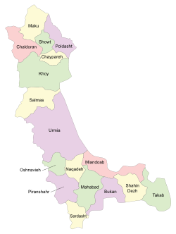 Counties of West Azerbaijan Province | |
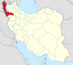 Location of West Azerbaijan Province in Iran | |
| Coordinates: 36°46′N 45°44′E / 36.767°N 45.733°ECoordinates: 36°46′N 45°44′E / 36.767°N 45.733°E | |
| Country |
|
| Province | West Azerbaijan |
| Capital | Mahabad |
| Bakhsh (Districts) | Central District, Khalifan District |
| Population (2017) | |
| • Total | 236,849 |
| Time zone | UTC+3:30 (IRST) |
| • Summer (DST) | UTC+4:30 (IRDT) |
| Mahabad County can be found at GEOnet Names Server, at this link, by opening the Advanced Search box, entering "9205914" in the "Unique Feature Id" form, and clicking on "Search Database". | |
Mahabad County (Persian: شهرستان مهاباد) is a county in West Azerbaijan Province in Iran. The capital of the county is Mahabad. Because of its strategic position and its proximity with the border the city is a stop for many travelers. At the 2006 census, the county's population was 197,441 (100,085 men and 97,358 women), in 42,493 families.[1] The county is subdivided into two districts: the Central District and Khalifan District. The county has one city: Mahabad.
Administrative divisions
According to the national 2006 census, the county is divided as follows:
Districts
Rural Districts
- Akhtachi-ye Gharbi Rural District, in Central District
- Mokriyan-e Gharbi Rural District, in Central District
- Mokriyan-e Sharqi Rural District, in Central District
- Kani Bazar Rural District, in Khalifan District
- Mangur-e Sharqi Rural District, in Khalifan District
Geography
The county, with an area of 2591 km², is approximatively located at 36°46'N,45°43'E. The climate is mountainous with cold winters and temperate summers. Mahabad river flows through the capital.
References
- ↑ "Census of the Islamic Republic of Iran, 1385 (2006)". Islamic Republic of Iran. Archived from the original (Excel) on 2011-11-11.
- اطلس گیتاشناسی استانهای ایران [Atlas Gitashenasi Ostanhai Iran] (Gitashenasi Province Atlas of Iran)
| Capital | 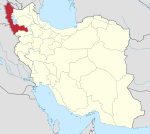 | |
|---|---|---|
| Counties and cities | ||
| Tourism | ||
| Places | ||
This article is issued from
Wikipedia.
The text is licensed under Creative Commons - Attribution - Sharealike.
Additional terms may apply for the media files.