Piranshahr
| Piranshar پیرانشهر مکریان | |
|---|---|
| City | |
| Piranshahr (Pîranşar) | |
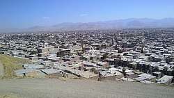 | |
 Piranshar | |
| Coordinates: 36°41′40″N 45°08′30″E / 36.69444°N 45.14167°ECoordinates: 36°41′40″N 45°08′30″E / 36.69444°N 45.14167°E | |
| Country |
|
| Province | West Azerbaijan |
| County | Piranshahr |
| Bakhsh | Central |
| Population (2016 census) | |
| • Total | 795,716 |
| Time zone | UTC+3:30 (IRST) |
| • Summer (DST) | UTC+4:30 (IRDT) |
| Area code(s) | +984444 |
| Website | http://www.pirancity.net |
Piranshahr. (Persian: پیرانشهر); (Kurdish: پیرانشاهر);[1] Azerbaijani: Khan-a Armenian: պիրանշար Kurmancî Kurdish: Pîranşahr) is a city geopolitically located in the Islamic Republic of Iran and geographically one of the cities in West Iran, but demographically situated in the Central parts of Iranian Kordestan and is geolinguistically located in the Eastern parts of the Greater Kurdish inhabited area. The city is administratively situated in the Western parts of Iranian Azarbayejan and is one of the southernmost cities in Greater Azerbaijan. Piranshahr is statistically part of Region 3/Northwest Iran and is coordinately one of the northernmost cities of North Iran, situated in 36°42'3.6"N and 45°8'28.68"E. [2] It is the capital of Piranshahr County.[3]
According to historical geogrpahy, Piranshahr was in ancient times part of Lesser Media, in the Middle Ages it was part of Eraqi Ajam/Persian Iraq and in modern period, Piranshahr was one of the centers of Mokrian.[4][5][6]
The inhabitants of Piranshahr are sometimes referred to as Piranshahri´s, but this term is also applied to those people who live in the neighburing communities.
Piranshahr is one of the Iran's oldest cities and its foundations date back to the pre-Islamic era of Iran and the emergence of the kingdom of Media.
The Farsi language is the official language of Iran and thus within the city of Piranshshr. In Piranshahr every literate person knows how to communicate in the Persian language. The literacy rate is 97%. A heavily Persianized variety of Mokriani Central Kurdish is spoken natively by the populace.
The city of Piranshahr produces a full range of over 100 different granite materials in a variety of colours and textures. The quality and the beauty of Piranshahr granites are one of the best-known in the world.
The city is one of the fastest-growing cities in Iran.[7] The government's mid-year census for 2016 puts Piranshahr's population at 591,515 compared with the 1996 figure of 424,000.[7] The city is forecast to have a population of 800.000 in 2020.
The current mayor and Governor General is: Doctor Zana Vahid Pourtehrani Pourlahiji.
Etymology
According to the Arab geographer Yaqut al-Hamawi, the name of the city is derived from the famous figure of Shahnameh Piran son of Viseh[8][9][10] Piran is a Turanian figure in Shahnameh, the national epic of Greater Iran. Beside Shahnameh, Piran is also mentioned in other sources such as Tabari and Tha'ālibī. He is the king of Khotan and the spahbed of Afrasiab, the king of Turan. He is described as a wise and intelligent man, seeking to bring peace to Iran and Turan. In old Iranian writings, Piran and Aghrirat are the only Turanians that have been described positively. Piran plays a vital role in the story of Siavash, the story of Kay Khosro and the story of Bizhan and Manizhe. In Persian culture and Kurdish culture, Piran is a symbol of wisdom.[11] It has been said that Karim Khan called Mohammad Khan Qajar "Piran Viseh".[11][12] Piran is often compared to Bozorgmehr.[10]
According to Djalal Khaleghi Motlagh, Piran may be the Median Harpagus that saved Cyrus the Great.[13]
Prehistory
The history of Piranshahr can be traced back to the Palaeolithic period. In recent discoveries, archeologists have found artifacts dating back to the Palaeolithic, Mesolithic, Neolithic, Bronze and Iron Ages.The earliest evidence of settlement in the Piranshar region date to about 14,000 years ago.
There have been recovered more than 250 sites in Piranshahr.
Prehistoric monuments (Legendary and decorative menhirs of Khorenj)
The word “Khorenj” means (area of the vote) which means full of menhirs. Here the name and the content agree. In fact, Khorenj is full of decorative and legendary menhirs. Khorenj is one of the one hundred villages in Piranshahr County that is located in the north west of Iran. Khorenj is located 30 km east of the county on the route of Mahabad road. The distance of the village to the paved road is 5.2 km, to the district center 12 km, and to the county seat 37 km.[14]
The climate of the village is temperate mountainous with cold and snowy summers, and mild and cool summers.
Around the village there are several ancient sites dating back to pre-Islamic era and an inscription as well as the remains of a strong mountain stronghold which reflects the ancient history of the region. Some of these sites are registered by the Cultural Heritage Organization of Iran, and others are on the register.[15]
Khorenj village is in one side neighbor with the historical town of Pasva which according to the evidences that have been mentioned in the book of history of Urumiyeh, Pasva is considered as the cradle of Parsua civilization. On the other hand, Khorenj is neighbor with the fortified and mountainous fortress of Qalat-E Shah, which according to Iranian archeologists, is the border fortress between the Parsua and Manna civilizations. The ancient site of Palas-Abad is also located in this village, which its historical background streches back to the 1000 BC. Also in the vicinity of the area, there is the Zab river which according to European and Iranian archeologists the Zab river have given birth to the Zamua civilization.
The Khorenj village is surrounded on the north side by a gently sloping uphill with a massive piece of menhirs. The presence of these pieces of menhirs with this stylish appearance and amazing setting will mesmarize every visitor.
The area occupied by these rocks is about 2.5 square kilometers and passes through the rocky strip in the East-West East from the north of the village. There is clear and lucid water in the highest point of these rocks that supplies the drinking water of all the villagers. Each and every point of the stones has a specific name.
The legendary menhirs behind this village that are four thousand meters long and four hundred meters wide have decorated Khorenj Village. There are various fruits and blessings among these decorative stones such as: 1. Figs in four tastes and colors (yellow, red, black, blue), 2. Raspberries (red and black), 3. Cherries (yellow, red, black), etc. and most importantly, there is clear and lucid water in the highest point of these rocks that supplies the drinking water of all the villagers. Each and every point of the stones has a specific name that will astound every visitor.
There is a point called Zendan (Prison) at the back of the aforementioned mountains and that is the crypt at ground level with unknown depth where the sound of water and wind can be heard and going through which is difficult and impossible.
Parsua civilization
The city of Piranshahr is the cradle of a 7000 years ancient civilization. Its locale was the capital of some ancient Aryan civilizations such as Medes, Urartu, Parsua and the kingdoms of the Mannaeans.
According to Minorsky, the ancient Parsua is identical with the name of the town Pasva, which is located in Lajan district (Bakhsh) in Piranshahr.[16] According to Minorsky, The name Persian is connected to the name of Parsua and Pasva and it is believed that the present day Persians (Persian speakers of Iran) dwelled in this district before later migrating to southern and central parts of Iran.
Pasva is in the vicinity of Piranshahr. Pasva is a village near Piranshahr whose name, according to the Iranist Vladimir Minorsky has existed since the 9th century BC and was built by the "Parsua tribes". It was also mentioned in the records of the Assyrian ruler Shalmaneser III (reign 858-824 BC).[17]
Historical background (Primary sources)
The first citation of the city in the historical literature belongs to the famous book Mojem Alboldan, by Yaqut Homavi (13th century) which introduces the Piranshahr or the Khan Khasbeig of that time, as the second most important town in the Lajan (Lahijan) area after the town of Pasva. Before this, Piranshahr had been probably not as important as a municipality but rather as a district community. However, the Piranshahr geographical area had its historical and political importance long before the emergence of the city of Piranshahr. Apart from literature, the oldest evidence on the history of the region is the ancient Barzinkaj inscription in the Dalavan (Delavaran) village some 8 km north west of Piranshahr.
Geography
The administrative division of Piranshahr is a paradox. In an arbitrary manner, a predominantly Kurdish-inhabited city is not located in the Ostan (province) of Kordestan, but in West Azerbaijan. The regional authorities have focused the Iranian Kurdistan on the city of Sanandaj, located 280 kilometers south of Piranshahr. Timid movements of local opinion, have called for a joining to the province of Kurdistan or for the creation of another Kurdish province called Mokrian whose epicenter was Piranshahr or Mahabad.
The Zagros forests of western Iran extend from Piranshahr city in western Azarbayejan province in the Zagros and Bakhtiary mountains to around the Jahroum and Fasa cities in the Fars province.
According to the Management and Planning Organization, the city has a total area of 154.9 square miles (401.3 km2), of which 1.6 square miles (4.1 km2), or 1.03%, is water.
Piranshahr is surrounded by four other counties: Oshnavieh and Naghadeh to the north, Mahabad to the east and Sardasht to the south. The city is also bordered by Iraq to the west
Climate
Piranshahr experiences variable weather, including four distinct seasons. In July, the warmest month, high temperatures average 29 °C (84 °F), and low temperatures 17 °C (63 °F). In January, the coldest month, High temperatures average -2 °C (29 °F), with low temperatures averaging -11 °C (13 °F).
Piranshahr's yearly precipitation averages about 965 mm (38 inches). Summer is the rainiest season, with short-lived rainfall and thunderstorms more common than prolonged rainy periods [3]. Winter is the driest season, with most of the precipitation falling as snow.
The highest temperature ever recorded in Piranshahr is an unofficial 44 °C (109 °F) on July 24, 1935. The highest official temperature ever recorded is 42 °C (105 °F) on July 17, 1995 during the Piranshahr Heat Wave. The coldest temperature ever recorded in Piranshahr is -33 °C (-27 °F) on January 20, 1985. On December 24, 1983, the high temperature at Piranshahr reached only -23 °C (-11 °F), and on July 30, 1916, the low temperature sank to only 29 °C (84 °F), both of which are records.
Winter in Piranshahr is a variable and fickle season. The average Piranshahr winter produces 940 mm (37.0 inches) of snow. This number can prove unreliable, as Piranshahr winters have produced between 249 and 2210 mm (9.8 and 87.0 inches) of snow. Snow tends to fall in light accumulations of around 50.8 mm (2 inches), but about once per year Piranshahr experiences a storm that can produce 254 to 356 mm (10 to 14 inches) of snow in one day. Temperatures can vary wildly within the span of one week, but extended periods of temperatures below 0 °C (32 °F) are not uncommon in January and February. The temperature in January averages about -4 °C (25 °F) in the afternoon, and -12 °C (10 °F) at night. Temperatures can be expected to drop below -18 °C (0 °F) on 15 days throughout the winter season. Although rare, temperatures in Piranshahr even in the middle of winter can reach 10 °C (50 °F).
Piranshahrs climate is classed under the Köppen climate classification as a Mediterranean climate (Csa) with continental influences.
| Climate data for Piranshahr, Iran | |||||||||||||
|---|---|---|---|---|---|---|---|---|---|---|---|---|---|
| Month | Jan | Feb | Mar | Apr | May | Jun | Jul | Aug | Sep | Oct | Nov | Dec | Year |
| Record high °C (°F) | 24.0 (75.2) |
26.0 (78.8) |
31.0 (87.8) |
33.0 (91.4) |
41.0 (105.8) |
43.0 (109.4) |
47.0 (116.6) |
46.0 (114.8) |
43.0 (109.4) |
37.0 (98.6) |
30.0 (86) |
24.0 (75.2) |
47 (116.6) |
| Average high °C (°F) | 10.9 (51.6) |
13.3 (55.9) |
17.5 (63.5) |
22.6 (72.7) |
28.9 (84) |
36.0 (96.8) |
39.5 (103.1) |
39.1 (102.4) |
35.0 (95) |
27.7 (81.9) |
19.7 (67.5) |
13.1 (55.6) |
25.3 (77.5) |
| Daily mean °C (°F) | 5.0 (41) |
7.1 (44.8) |
11.0 (51.8) |
15.7 (60.3) |
21.2 (70.2) |
27.0 (80.6) |
30.8 (87.4) |
29.8 (85.6) |
25.3 (77.5) |
19.1 (66.4) |
12.3 (54.1) |
6.9 (44.4) |
17.6 (63.7) |
| Average low °C (°F) | 0.1 (32.2) |
1.4 (34.5) |
4.6 (40.3) |
8.3 (46.9) |
11.9 (53.4) |
15.4 (59.7) |
19.5 (67.1) |
18.7 (65.7) |
14.1 (57.4) |
10.0 (50) |
5.5 (41.9) |
1.8 (35.2) |
9.3 (48.7) |
| Record low °C (°F) | −14.6 (5.7) |
−11.0 (12.2) |
−11 (12) |
−2.0 (28.4) |
−1.8 (28.8) |
7.0 (44.6) |
9.2 (48.6) |
8.0 (46.4) |
4.6 (40.3) |
−1.4 (29.5) |
−7.8 (18) |
−8.6 (16.5) |
−14.6 (5.7) |
| Average precipitation mm (inches) | 86.0 (3.386) |
73.1 (2.878) |
82.5 (3.248) |
71.6 (2.819) |
36.5 (1.437) |
0.3 (0.012) |
0.1 (0.004) |
0.2 (0.008) |
1.2 (0.047) |
23.5 (0.925) |
54.3 (2.138) |
83.6 (3.291) |
512.9 (20.193) |
| Average rainy days | 11.9 | 10.7 | 12.9 | 11.0 | 6.2 | 0.4 | 0.3 | 0.2 | 0.4 | 4.8 | 7.6 | 10.1 | 76.5 |
| Average snowy days | 2.6 | 1.5 | 0.7 | 0 | 0 | 0 | 0 | 0 | 0 | 0 | 0.1 | 0.9 | 5.8 |
| Average relative humidity (%) | 69 | 64 | 58 | 54 | 43 | 28 | 24 | 25 | 28 | 39 | 55 | 66 | 46.1 |
| Mean monthly sunshine hours | 163.4 | 170.8 | 187.2 | 206.0 | 264.2 | 340.4 | 347.2 | 330.1 | 302.7 | 257.3 | 191.4 | 160.5 | 2,921.2 |
| Source: NOAA (1961-1990)[18] | |||||||||||||
Geology
Piranshahr has no active or dormant volcanoes and few earthquakes, however many residents of Piranshahr feel one or two minor earthquakes per year, which do little or no damage. Imperceptible quakes are detected by seismometers on a daily basis.
Agriculture
West Azarbaijan Rural Cooperative Organization has bought some 470,000 tons of wheat, valued at Rls.840 billion, from farmers since the beginning of the year. Among West Azarbaijan cities, Piranshar is considered a fine example in agriculture improvements. Since 2002, most of the investments in the city are made in the agricultural sector. Consequently, farm and garden coverage in Piranshar has extended from 80 square kilometres in 2002 to 190 km2 in 2004.
Economy
The Piranshar economy includes that of the city of Piranshar and the surrounding towns and villages. The Piranshar area is an engine of the provincial economy. The city of Piranshar has the most important sugar company in the province. There are four Sugar Companies in the province including the Sugar Company of Piranshar.
The plant, in the course of years of its activity, has been constantly renovated by making use of the existing capabilities in the plant. The plant produces 30,000 tons of sugar annually (from 1500 tons of sugar beet per day), and by-products include 100 tons of dried waste per day, which is used for animal food, and 3000 tons of medico-industrial alcohol produced annually from molasses.
Considering the national demand for sugar of 1.5 million tons per year, and the supply thereof by 35 manufacturing units equivalent to 800 thousand tons, and the consequent considerable shortage of sugar, the manufacture of such a product is significant.
Sugar beet is supplied by 70 km2 of farmland around the plant.
The Sugar Company of Piranshahr is the province's largest producer of raw sugar, accounting for over 60% of all of the province's sugar.
Education
Piranshahr has an educated population and its literacy rate is very high: of Piranshahr's population over 28.60% (vs. a national average of 24%) hold a bachelor's degree or higher; 94% (vs. 82% nationally) have a high school diploma or equivalent. In fact, Piranshahr has the highest percentage of college graduates of any city in the entire country.
The main institutions of higher education in the area are Payame Noor University and Islamic Azad University.[19] The city is also home to a number of conservatories and art schools.
Transportation
Road 26 is a road in north-western Iran connecting Mianeh to Miandoab, Mahabad and Piranshahr with Tabriz.
Neighborhoods
The city of Piranshahr includes some of the following neighborhoods:
Zana, Vahid, Balashahr, Kuy Omid, Kuy Baradaran, Kuy As´habe kahf, Kuy Khayyam, Kuy Kamran, Kuy Mokrian, Kuy Lajan (Lahijan), Niloufar park, Sardaran, Bazarcheh. Kuy Edalat, Nirougah, Azadegan, Isargaran, Padash, Farhangian 1, 2, 3 and 4, Ghods, Chahar-Rahe Madar (22 Bahman), Ashianeh 32 metri, Darreh Garav, Zargatan, Seyyed Ghotb, Azadi, Molla Reza, Qapan, Kohne Khaneh, Kanie Kohneh Khaneh.
Demographics
The ethnic composition of Piranshahr is 95% Kurd, 3% Azarbaijani and 2% Persian (Fars).
According to Piranshahr's organization for Civil Registration, the highest average annual growth rate in the province is in Piranshahr.[20]
The population history of the city proper is as follows. All figures are official census figures from the Iranian Statistics Institute.[21]
| 1956 | 1966 | 1976 | 1986 | 1991 | 2000 | 2006 | 2016 |
|---|---|---|---|---|---|---|---|
| 5,251 | 8,076 | 12,963 | 18,242 | 23,923 | 50,351 | 78,470 | 95,716 |
Language
Mokriani dialect of Central Kurdish is widely spoken in the city of Piranshahr. Mahabad and Piranshahr are two principal cities of the dialect area.
Religion
The people of the city of Piranshahr are almost all entirely Sunni Muslims. The Sunni Islamic faith (Shafiite branch) dominates the culture, norms, traditions, and beliefs of the city, and continues to dictate the style of life in city. There are also a minority of Shia Muslims in Piranshahr. The followers of Shiism are mainly Persian speakers and Azerbaijanis who are called Ajam by the local people.
Prominent people
- Soleyman Pakseresht, Iranian sociologist and associate professor at Bu-Ali Sina University, also the deputy of the Iranian Ministry of Cooperatives, Labour, and Social Welfare.
Law and government
The city's chief administrator is the mayor, who is elected by the municipal board of the city. According to Iranian laws the municipal board is periodically elected by the city residents.
Mayor: Doctor Zana Vahid Pourtehrani Pourlahiji [22]
Governor: Ali Davoudi[23]
Friday prayer: Mamousta Mostafa Mahmoudi[24]
Majlis representative: Dr Rasoul Khezri[25]
The Iran-Iraq War
During the Iran-Iraq War it was extensively ravaged by Iraqi forces as a result of Iraqis scorched earth policy. Prior to the war, Piranshahr had grown extensively to become a major border city, and had a population of more than 150,000. The population was predominantly wealthy and educated.
As the Iraqis drew near at the beginning of the war, the Iranian Army evacuated much of the city. In the defense of Piranshahr, the Iranians prepared a series of dykes on the outskirts of the city, the first dyke holding regular soldiers and the second dyke holding tanks, artillery, and antitank weapons. Personnel wise, the Iranian Regular Army was responsible for the city’s external defenses and the Pasdaran were responsible for the center.
Sport
The city boasts a wide variety of sports facilities and teams. Football is the most popular sport in Piranshahr and Piranshahr is home to many famous football teams including Granite Sabz, Shahredari and Yaran.
Higher education
Some of the major centers of higher education are as followed:
- University of Piranshahr
- Islamic Azad University of Piranshahr
- Payame Noor University
Distances in kilometers to other cities in the province
Piranshahr: *
Mahabad: 91 km
Oshnaviyeh: 46 km
Sardasht: 95 km
Bukan: 202 km
Takab: 286 km
Shahindej: 203 km
Chaldoran: 369 km
Maku:422 km
Naghadeh: 46 km
Miandoab: 142 km
Salmas: 237
Khoy: 280 km
Distance to provincial centres
- Rasht 803 km
- Sari 1041 km
- Gorgan 1171 km
- Semnan 1010 km
- Bojnurd 1487
- Birjand 2078 km
- Hamadan 551 km
- Ghazvin 630 km
- Tehran 774 km
- Mashhad 1668 km
- Ahvaz 1010 km
- Bushehr 1495
- Bandar Abbas 1972 km
- Zahedan 2205 km
- Kerman 1676 km
- Yazd 1215 km
- Esfahan 1014 km
- Shiraz 1500 km
- Arak 727 km
- Qom 840 km
- Tabriz 296 km
- Orumiyeh: 146 km
- Ardabil 515 km
- Zanjan 455 km
- Kermanshah 523 km
- Sanandaj 340 km
- Ilam 707 km
- Khorramabad 814 km
- Shahrekord 1119 km
- Yasuj 1214 km
- Karaj 670 km
Alternative spellings
- Piranshar
- Piranchar
- Piranschar
- Piransar
- Piranshahr
- Piranschahr
- Piranchahr
- Piransahr
- Piran Shahr
- Piran Chahr
- Piran Schahr
- Piran Sahr
- Piran Sar
- Piran Char
- Piran Shar
- Piran Schar
- Mokrian
- Mukrian
References
- ↑ Piranshahr can be found at GEOnet Names Server, at this link, by opening the Advanced Search box, entering "-3073397" in the "Unique Feature Id" form, and clicking on "Search Database".
- ↑ "West Azerbaijan Province". Iran-China Chamber of Commerce and Industries. January 9, 2010. Retrieved 2015-10-16.
- ↑ "English/Iran's non-oil exports via Piranshahr customs hit $125mn in 9 months". mefa.ir. Archived from the original on 2015-01-19. Retrieved 2015-04-06.
- ↑ "Archived copy". Archived from the original on 2015-01-19. Retrieved 2017-03-04.
- ↑ "Though They Come from the Ends of the Earth: A Novel of the Iran Nuclear ... - Carl Douglass - Google Břker". Books.google.no. Retrieved 2018-06-01.
- ↑ "سرآمد | نمایشگاه رسانه های دیجیتال استان آذربایجان غربی". Exhibition.saramad.ir. Retrieved 2018-06-01.
- 1 2 "West Azerbaijan (Iran): Counties & Cities - Population Statistics, Charts and Map". Citypopulation.de. Retrieved 1 June 2018.
- ↑ Bashiri, Iraj. "Characters of Firdowsi's Shahname". Retrieved 15 February 2016.
- ↑ "مغز متفکر شاهنامه (تحلیلی بر شخصیت پیران ویسه)". noormags. Retrieved 15 February 2016.
- 1 2 "Piran in Shahnameh". Retrieved 15 February 2016.
- 1 2 "Piran Viseh". Retrieved 15 February 2016.
- ↑ "دلبستگی موسس قاجاریه به شاهنامه/ شاهی که کریمخان وی را "پیران ویسه" نامید". IBNA.ir. Retrieved 15 February 2016.
- ↑ "Cyrus and Kay Khosro". Retrieved 15 February 2016.
- ↑ "سرزمین سنگهای افسانه ای روستای خورنج در پیرانشهر + تصاویر". Dana.ir. Retrieved 2018-06-01.
- ↑ "Khorenj Village – Piranshahr Iran Tourist Attractions". Travital.com. Retrieved 1 June 2018.
- ↑ "The Cambridge History of Iran - Google Břker". Books.google.no. Retrieved 2018-06-01.
- ↑ Minorsky, V. (1 June 2018). "Mongol Place-Names in Mukri Kurdistan (Mongolica, 4)". Bulletin of the School of Oriental and African Studies, University of London. 19 (1): 58–81. JSTOR 609632.
- ↑ "Khoram Abad Climate Normals 1961-1990". National Oceanic and Atmospheric Administration. Retrieved December 28, 2012.
- ↑ "دانشگاه آزاد اسلامی پیرانشهر". piranshahr-iau.ac.ir. Retrieved 2015-04-06.
- ↑ "رئيس اداره ثبت احوال پيرانشهر: بيشترين ميانگين نرخ رشد جمعيت استان مربوط به پيرانشهر است". Farsnews.com. Retrieved 2018-06-01.
- ↑ "Iran Statistics Institute". Archived from the original on 11 July 2011. Retrieved 1 June 2012.
- ↑ "پورتال شهرداری پیرانشهر". Picity.net. Retrieved 2018-06-01.
- ↑ "فرمانداری پیرانشهر". Piranshahr-ag.ir. Retrieved 2018-06-01.
- ↑ "امام جمعه پیرانشهر: بیلیاقتی آل سعود در مدیریت حج اثبات شده است". Farsnews.com. 2016-12-09. Retrieved 2018-06-01.
- ↑ "صفحه خانگی | وب سایت رسمی دکتر رسول خضری نماینده مردم شریف پیرانشهر و سردشت در مجلس شورای اسلامی". Drkhezri.ir. Retrieved 2018-06-01.