MAX Blue Line
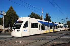
The MAX Blue Line is a light rail line that is part of the MAX Light Rail system in Portland, Oregon, United States. The line, the longest in the system, is owned and operated by TriMet; it connects the cities of Hillsboro, Beaverton, Portland, and Gresham via 51 stations on 32.7 miles (52.6 km) of track. It is the busiest of the five MAX lines, carrying an average 55,360 riders per day on weekdays in May 2018. The Blue Line is a Frequent Service route, running for 22½ hours per day from Monday to Thursday, with daily headways of between fifteen minutes off-peak and five minutes during rush hour. Service runs later in the evening on Fridays and Saturdays, and ends earlier on Sundays.
Local governments approved the construction of a light rail system in Portland in 1978 following the freeway revolts of the early 1970s. Referred to as the Banfield light rail project during its planning and construction, the line's eastern half—between downtown Portland and Gresham—began construction in 1982 and opened in 1986 as the first line of the MAX system. Its western half to Hillsboro, known as the Westside MAX, opened in 1998. The line's color designation was introduced in 2000 and was implemented the following year. Since 2003, the Blue Line has shared its stops with the Red Line from Beaverton Transit Center to Rose Quarter Transit Center, and since 2009 with both the Red and the Green lines from Rose Quarter Transit Center to Gateway/Northeast 99th Avenue Transit Center.
Early history
Background and early freeway proposals
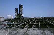
In the early 20th century, privately-funded inter-urban railways gave Portland one of the largest urban rail systems in the American West, including lines that once extended eastwards from Forest Grove and Hillsboro to Gresham and Troutdale.[2] In 1912, as the city's population exceeded 250,000, transit ridership rose to 70 million passengers annually.[3] By the 1920s, streetcars started to decline in line with the rise of the automobile and suburban and freeway development.[4] The Portland area's last two inter-urban lines, which went to Oregon City and Bellrose (Southeast 136th Avenue), ceased operation in 1958.[5][6]
_(247).jpg)
In 1955, the Oregon State Highway Department laid out the freeway development plan for the Portland metropolitan area, proposing the construction of the Mount Hood Freeway and Interstate 505.[7] The Mount Hood Freeway was a planned eight-lane section of Interstate 84 that would have traversed Division Street and Powell Boulevard in Southeast Portland, connecting Interstate 5 from the Marquam Bridge to eastern Multnomah County.[8][9] Citizen protests and two other factors led to the eventual cancellation of the Mount Hood Freeway project. In 1973, an environmental impact study conducted by Skidmore, Owings & Merrill declared that the freeway would reach obsolescence by the time it was completed and would add more traffic to downtown Portland than the surface streets could handle.[9][10] Then, in February 1974, district judge James M. Burns formally rejected the plan, ruling that the corridor selection process failed to follow the correct procedures.[11][10] Amid mounting anti-freeway sentiment and further delays to the project, in July 1974, Portland City Council voted 4-to-1 to abandon the plan, and county and state authorities followed shortly after.[12]
At the same time, residents in Northwest Portland opposed Interstate 505.[13] In 1971, the city council voted to approve the spur route, initially backed by the Northwest District Association (NWDA), which saw it as a barrier to industrial encroachment.[14] Following a suspect environmental impact study, organizers from the Willamette Heights Neighborhood Association filed a class action in U.S. district court to halt the new freeway's construction, and were later joined by the NWDA.[14][15] Several years of drawn-out litigation ensued, keeping the project on hiatus. In December 1978, the city council withdrew its support for the proposal; this decision was backed by Governor Vic Atiyeh in 1979. After its removal from Oregon's interstate plan, $15 million of its funds was reallocated to the Banfield project.[16]
Banfield light rail project
The passage of the Federal-Aid Highway Act in 1973 allowed state governments for the first time to transfer federal funds from canceled highway projects to other transportation options, including mass transit.[12] In May 1973, Governor Tom McCall assembled a task force to determine potential alternative uses for transferred freeway funds, and in April 1974, he released a preliminary draft listing light rail and buses as modes under consideration.[17] The Oregon Public Utility Commission also proposed a regional light rail system using existing railroad rights of way, while Goldschmidt persuaded the Columbia Region Association of Governments (CRAG) board to channel the transfer funds towards improving access to downtown Portland.[12]
With the freeway plans canceled, $500 million of federal assistance became available and were used on other transportation projects throughout the region, including $60 million allocated to the Banfield transit corridor.[18] The proposed transitway was originally conceived of as a busway but support for light rail on the corridor grew following the release of an environmental impact study in 1977.[19][20] In 1978, the cities Portland and Gresham, Multnomah County, CRAG, the Oregon Department of Transportation, and Tri-Met adopted a resolution supporting a combined Banfield light rail and highway expansion plan.[19][21] Tri-Met selected Wilbur Smith Associates to produce the engineering plans. In June 1979, Portland City Council approved the downtown alignment[22] and in September 1980, the Banfield light rail project received federal approval for construction.[23]
_-_Portland%2C_Oregon.jpg)
Light rail alignment and conceptual designs were finalized in November 1981. The original, 27-station line spanned 15.1 miles (24.3 km) from 11th Avenue in downtown Portland to just east of Cleveland Avenue in Gresham.[23] The stations and overpasses were designed by Zimmer Gunsul Frasca, which earned the firm a Progressive Architecture Award in 1984.[24] Anticipating 42,500 riders on the line by 1990, Tri-Met purchased 26 Bombardier light rail vehicles.[23] On March 26, 1982, the groundbreaking ceremony took place at Ruby Junction Yard, with U.S. Senator Mark Hatfield, Governor Vic Atiyeh, and officials from the Urban Mass Transportation Administration (UMTA) in attendance.[25] Construction commenced in April 1983 along the Gresham alignment. The Ruby Junction maintenance facility was completed in 1983 and the first rail car arrived in 1984.[26] In order to minimize costs, light rail and freeway work were done simultaneously.[25] The alignment crossed the Willamette River on the Steel Bridge, and was one factor that necessitated a $10 million rehabilitation of the bridge from 1984 to 1986.[27] System testing followed the bridge's reopening in spring 1986.[26]
On September 5, 1986, the $214 million (equivalent to $955 million in 2016 dollars) Banfield light rail—now Metropolitan Area Express (MAX)—opened for service. Federal transfer funds provided $178.3 million, 83 percent of the budget;[20] the project was completed $10 million under budget.[24] Its new name was selected through a public contest; the winning suggestion was made by Tri-Met designer Jeff Frane, who attributed inspiration to his son, Alex.[28] Opening celebrations spanned three days and were attended by an estimated 250,000 people.[24] Initially projected to carry 12,000 riders per day, the MAX averaged around 18,000 by December 1986. Downtown retailers, many of whom had opposed the system, reported substantial increases in sales following the line's opening.[29]
Westside extension
Early planning and delays
Planning for the restoration of services between downtown Portland and Hillsboro—formerly served by the Oregon Electric Railway (OE)—began in 1979 with a proposed route initially terminating at 185th Avenue and Walker Road.[30][31] In 1983, Metro—the successor to CRAG—and local jurisdictions selected light rail as the preferred mode alternative and UMTA released funds to begin preliminary engineering work later that year.[31] The project, however, was suspended by Tri-Met to make way for the Banfield light rail's construction and further planning did not commence until 1988.[32]
By the time the project was restarted, significant changes in the westside corridor warranted a re-evaluation of the previously adopted plan. In particular, between 1980 and 1984, 3,000 acres (12,140,569.3 m2) of vacant Washington County land had been converted into mixed-use urban areas, spurring new development in Hillsboro that stood well above the regional average.[31] In 1985, newly appointed Hillsboro Mayor Shirley Huffman began lobbying for the line's extension to downtown Hillsboro; she traveled frequently to Washington, D.C. to persuade Congress and infamously made a "stern" telephone call to the head of UMTA in 1990.[33] The efforts of Huffman and others led to the preparation of a supplemental study in 1991[31] and in July 1993,[34] Tri-Met approved an extension of the line 6.2 miles (10 km) farther west, bringing the total distance of the extension to 18 miles (29 km).[35]
Funding and construction

Funding for the Westside MAX proved difficult under the Reagan Administration, which sought to reduce federal expenditures by delaying existing light rail projects and declining federal approval for future planning.[36] As members of their respective appropriations committees, U.S. Senator Mark Hatfield and U.S. Representative Les AuCoin secured preliminary engineering and environmental review grants in 1989 by denying funding for the head of UMTA's office.[37][38] In 1990, voters approved a $125-million ballot measure to fund the line's construction, the region's first successful vote approving public transit. Under new leadership, the Federal Transit Administration (FTA)—the new name for UMTA—completed the funding package in 1992 by granting $516 million to build the line up to 185th Avenue, which was projected to open in September 1997. It provided an additional $113 million in 1994 following the approval of the Hillsboro extension.[39]
Construction of the Westside MAX began in August 1993,[40] with the excavation of the 21-foot-diameter (6.4 m) Robertson Tunnel,[32] one of the most complex segments during planning. Several alternative alignments through the West Hills were studied, including an all-surface option along the Sunset Highway (U.S. 26), an option with a half-mile-long (0.8 km) "short tunnel", and an option with a three-mile (4.8 km) "long tunnel".[41][42] Tri-Met chose the "long tunnel" in April 1991.[43]The project's general contractor, Frontier-Traylor, a joint-venture of Frontier-Kemper Constructors and Traylor Brothers,[44] used conventional drilling and blasting techniques to dig through the west end.[32] On the east segment, a 278-foot (85 m) tunnel boring machine was used to drill for two miles.[45] Highly-fragmented rock initially made the machine excavation difficult, delaying the project for nine months.[45] In August 1995, Tri-Met postponed the extension's planned opening to 185th Avenue by one year to September 1998.[46] In 1996, a large maintenance facility near the Elmonica/SW 170th Avenue station was opened.[47] The final rail spike was driven on Hillsboro's Main Street Bridge and the tunnel was completed in October 1997.[48] Final testing followed the completion of track signals and power installation in June 1998.[49]
Opening
On August 31, 1997, the Westside MAX opened its first section, a two-station extension west to Kings Hill/SW Salmon Street station,[50] in conjunction with the entry into service of North America's first low-floor light rail cars.[51] Grand opening celebrations for the entire $963.5 million (equivalent to $1.36 billion in 2016 dollars) line took place on September 12, 1998.[48] Ceremonies were held at Gresham City Hall, Civic Stadium, Beaverton Creek, and Hillsboro Government Center stations; speeches were delivered by local and regional dignitaries, former Governor and U.S. Senator Mark Hatfield, Governor John Kitzhaber, U.S. Secretary of Transportation Rodney E. Slater, and Vice President Al Gore.[52] The line immediately drew strong ridership, exceeding projections for 2005 less than two years after it opened.[53] In September 2000, with the opening of the Airport MAX extension less than a year away, Tri-Met adopted a color coding scheme to differentiate its trains from those operating between Hillsboro and Gresham, assigning blue as the eastside and westside lines' color designation,[54] a line-identification system that was adopted shortly before the Red Line's opening in 2001.[55]
Route
.jpg)
.jpg)
The Blue Line's total length is 32.7 miles (52.6 km).[56][57] Its western terminus is Hatfield Government Center station in Hillsboro on the corner of West Main Street and Southwest Adams Avenue.[58] The line heads east along the median of Southeast Washington Street for 14 blocks. It continues east on a formerly abandoned Burlington Northern Railroad (BN)—former OE—right-of-way between Southeast 10th Avenue and Cornelius Pass Road, and a former BN right-of-way between Cornelius Pass Road and 185th Avenue,[34] traveling mostly at-grade except at grade-separated crossings—notably, the Main Street Bridge and Cornelius Pass Road—until it reaches Beaverton Transit Center.[30] It then turns north, running adjacent to Oregon Highway 217 to the Sunset Transit Center, from where it continues eastwards along the north side of Sunset Highway before entering the Robertson Tunnel for Washington Park station.[32]
After leaving the tunnel, the line passes below the Vista Bridge, continues along Southwest Jefferson Street, and turns north onto the median of Southwest 18th Avenue.[59] Near Providence Park, the tracks diverge eastwards onto Southwest Yamhill Street and westwards onto Southwest Morrison Street. The tracks reconnect on Southwest 1st Avenue and head north, crossing the Willamette River via the Steel Bridge into the Rose Quarter. The line runs along Holladay Street in the Rose Quarter and the Lloyd District, passing the Oregon Convention Center.[60] The line leaves the Lloyd District near Exit 1 of Interstate 84 and travels east along the north side of the Banfield Freeway.[61] It then crosses over the intersection of Interstate 84 and Interstate 205 towards Gateway/Northeast 99th Avenue Transit Center.[62] From Gateway Transit Center, the line heads south and then east, entering the median of East Burnside Street until it reaches Ruby Junction/East 197th Avenue station. It leaves the street there, heading southeastwards on a former railroad right-of-way until reaching its eastern terminus, Cleveland Avenue station near the corner of NE Cleveland Avenue and NE 8th Street in Gresham.[63]
The Blue Line shares much of its alignment with the Red Line, originally from 11th Avenue loop tracks in downtown Portland then Beaverton Transit Center since 2001 and 2003, respectively, to Gateway/Northeast 99th Avenue Transit Center, where the Red line diverges towards Portland International Airport.[64][65] The Green Line joined a part of the shared alignment in 2009, entering from the Portland Transit Mall just west of the Steel Bridge, diverging at Gateway/Northeast 99th Avenue Transit Center, and continuing south towards Clackamas.[66]

Stations
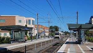
The Blue Line is served by 51 stations. The original section between Gresham and downtown Portland was built with 27 stations.[23] The Mall and Southwest 4th & 5th stations were added along with the opening of Pioneer Place in March 1990,[67] followed by the Convention Center station in September.[68] The Westside MAX opened in two stages due to delays in construction.[46] The first two stations, Civic Stadium—now Providence Park—and Kings Hill/Southwest Salmon Street opened in August 1997. The remaining 18 stations opened during the extension's inauguration in September 1998.[48] The newest station is Civic Drive, which was completed in 2010.[69]
Nearly all stations along the Blue Line are at-grade, the exceptions being Washington Park station—the only underground station within the Robertson Tunnel and the deepest transit station in North America at 260 feet (79 m) below the ground—and Sunset Transit Center.[32]
| Station | Opened | Transfers[70] | Connections[70][71][72] | Park and ride[73] | Secure bike parking[74] |
|---|---|---|---|---|---|
| Hillsboro | |||||
| Hatfield Government Center | 1998 | — | — | 250 spaces | Yes |
| Hillsboro Central/Southeast 3rd Avenue Transit Center | 1998 | — | — | Yes | |
| Tuality Hospital/Southeast 8th Avenue | 1998 | — | — | 85 spaces | Yes |
| Washington/Southeast 12th Avenue | 1998 | — | — | — | Yes |
| Fair Complex/Hillsboro Airport | 1998 | — | 396 spaces | Yes | |
| Hawthorn Farm | 1998 | — | — | — | Yes |
| Orenco | 1998 | — | 125 spaces | Yes | |
| Quatama | 1998 | — | — | 310 spaces | Yes |
| Willow Creek/Southwest 185th Avenue Transit Center | 1998 | — | 595 spaces | Yes | |
| Beaverton | |||||
| Elmonica/Southwest 170th Avenue | 1998 | — | — | 435 spaces | Yes |
| Merlo Road/Southwest 158th Avenue | 1998 | — | — | Yes | |
| Beaverton Creek | 1998 | — | — | 417 spaces | Yes |
| Millikan Way | 1998 | — | 400 spaces | Yes | |
| Beaverton Central | 1998 | — | — | — | Yes |
| Beaverton Transit Center | 1998 | WES Commuter Rail |
— | Yes | |
| Portland | |||||
| Sunset Transit Center | 1998 | 622 spaces | Yes | ||
| Washington Park | 1998 | — | Yes | ||
| Goose Hollow/Southwest Jefferson Street | 1998 | — | No | ||
| Kings Hill/Southwest Salmon Street | 1997 | — | — | No | |
| Providence Park | 1997 | — | Yes | ||
| Library/Southwest 9th Avenue (eastbound) | 1986 | A Loop, B Loop, NS Line | — | No | |
| Galleria/Southwest 10th Avenue (westbound) | 1986 | — | No | ||
| Pioneer Square South (eastbound) | 1986 | Portland Transit Mall | — | No | |
| Pioneer Square North (westbound) | 1986 | — | No | ||
| Mall/Southwest 4th Avenue (eastbound) | 1990 | — | No | ||
| Mall/Southwest 5th Avenue (westbound) | 1990 | — | No | ||
| Yamhill District (eastbound) | 1986 | — | — | No | |
| Morrison/Southwest 3rd Avenue (westbound) | 1986 | — | — | No | |
| Oak Street/Southwest 1st Avenue | 1986 | — | — | No | |
| Skidmore Fountain | 1986 | — | — | No | |
| Old Town/Chinatown | 1986 | — | — | No | |
| Rose Quarter Transit Center | 1986 | — | Yes | ||
| Convention Center | 1990 | A Loop, B Loop |
— | No | |
| Northeast 7th Avenue | 1986 | A Loop | — | No | |
| Lloyd Center/Northeast 11th Avenue | 1986 | — | No | ||
| Hollywood/Northeast 42nd Avenue Transit Center | 1986 | — | Yes | ||
| Northeast 60th Avenue | 1986 | — | Yes | ||
| Northeast 82nd Avenue | 1986 | — | Yes | ||
| Gateway/Northeast 99th Avenue Transit Center | 1986 | 690 spaces | Yes | ||
| East 102nd Avenue | 1986 | — | — | No | |
| East 122nd Avenue | 1986 | — | 612 spaces | Yes | |
| East 148th Avenue | 1986 | — | — | — | No |
| East 162nd Avenue | 1986 | — | — | No | |
| Gresham | |||||
| East 172nd Avenue | 1986 | — | — | — | No |
| East 181st Avenue | 1986 | — | 247 spaces | No | |
| Rockwood/East 188th Avenue | 1986 | — | — | No | |
| Ruby Junction/East 197th Avenue | 1986 | — | — | — | No |
| Civic Drive | 2010 | — | — | — | Yes |
| Gresham City Hall | 1986 | — | 417 spaces | Yes | |
| Gresham Central Transit Center | 1986 | — | 540 spaces | Yes | |
| Cleveland Avenue | 1986 | — | — | 392 spaces | Yes |
Service
From Monday to Thursday, the Blue Line runs for 22½ hours per day. Beginning service goes westbound from Elmonica/Southwest 170th Avenue station and the last trip goes eastbound from Rose Quarter Transit Center to Ruby Junction/East 197th Avenue station. Additional late-night trips are provided on Fridays and Saturdays; the last trip goes eastbound from Hatfield Government Center station to Elmonica/Southwest 170th Avenue station.[76][77] Except for additional late-night trips on Saturdays, weekend service runs on a slightly reduced schedule. TriMet designates the Blue Line as a Frequent Service route along with the rest of the light rail system, ensuring services run on a 15-minute headway for most of each day.[78] Trains run most frequently during weekday rush hours, operating on headways as short as five minutes.[76][79]
Ridership
| Average weekday ridership, 2017 | ||
|---|---|---|
| Period | Passengers | %± |
| Jan-Mar | 57,233 | -1.1% |
| Apr-Jun | 57,650 | +0.7% |
| Jul-Sep | 57,020 | -1.1% |
| Oct-Dec | 54,303 | -4.8% |
| Source: TriMet[80] | ||
The Blue Line is the busiest of the five light rail lines, carrying 18.9 million passengers in 2015[20] and averaging 55,360 riders on weekdays in May 2018.[1] Ridership on the entire MAX system, however, has fallen to just over 77 million passengers since peaking at around 80 million in 2012. In the first three months of 2017, the Blue Line recorded an average 55,233 rides per weekday, a drop of 2.9 percent from the same period in 2016.[81] TriMet attributes the drop to lower-income riders being forced out of the inner city by rising housing prices.[82]
Accessibility and safety

Stations on the original MAX line were built with wayside lifts to accommodate riders with disabilities on the high-floor, first generation vehicles. The lifts were installed on each station platform, rather than on the trains, to prevent malfunctions from potentially delaying services.[20] Increased use of the lifts ultimately became the cause of delays.[32] Additionally, many users felt stigmatized by the lifts' "box" design and time-consuming operation.[83]
Following the passing into law of the Americans with Disabilities (ADA) Act of 1990, TriMet began considering changes to enhance accessibility with the submission of a paratransit plan to the FTA in January 1992.[84] Before the commencement of the Westside MAX project, the MAX became the first light rail system in North America to obtain low-floor vehicles after a TriMet study of European systems.[32] The first low-floor cars, which were designed by Siemens, entered service in August 1997.[83]
In 2011, TriMet began upgrading sections of the Blue Line to improve pedestrian safety and compliance with updated ADA standards.[85] In 2013, pipe barriers were installed at Gateway/Northeast 99th Avenue Transit Center platform crossings to force pedestrians to slow down and face oncoming trains before crossing the tracks. In 2014, TriMet realigned sidewalks and crosswalks at four at-grade crossings in Gresham. Other improvements made throughout the line include pedestrian warning signal installations and tactile paving upgrades.[86]
References
- 1 2 "May 2018 Monthly Performance Report" (PDF). TriMet. Retrieved July 24, 2018.
- ↑ Selinger 2015, p. 7–8.
- ↑ Selinger 2015, p. 8.
- ↑ Selinger 2015, p. 9.
- ↑ Thompson, Richard H. (2012). Portland's Interurban Railway. Arcadia Publishing. pp. 61, 93. ISBN 978-0-7385-9617-4.
- ↑ Selinger 2015, p. 10.
- ↑ Shoemaker, Mervin (June 29, 1955). "Plan Given for Traffic of Future - Highway Engineer Submits Report to Commission". The Oregonian. p. Front.
- ↑ United States. Federal Highway Administation (1978). Powell Blvd, Phase II, Mt.Hood Hwy 26, Multnomah County: Environmental Impact Statement (Report). 1. Federal Highway Administration. p. 1. Retrieved July 26, 2018.
- 1 2 Sultana, Selima; Weber, Joe, eds. (2016). Minicars, Maglevs, and Mopeds: Modern Modes of Transportation Around the World: Modern Modes of Transportation around the World. ABC-CLIO. p. 314. ISBN 1440834954.
- 1 2 Mesh, Aaron (November 4, 2014). "Feb. 4, 1974: Portland kills the Mount Hood Freeway..." Willamette Week. Archived from the original on October 10, 2018. Retrieved July 26, 2018.
- ↑ Young, Bob (March 8, 2005). "Highway to Hell". Willamette Week. Archived from the original on September 17, 2018. Retrieved July 26, 2018.
- 1 2 3 Selinger 2015, p. 20.
- ↑ Burke, Lucas N. N.; Jeffries, Judson L. (2016). The Portland Black Panthers: Empowering Albina and Remaking a City. University of Washington Press. p. 193. ISBN 9780295806303.
- 1 2 Paglin, Morton (June 28, 2004). "Effort to stop freeway remembered". The Oregonian. p. B6.
- ↑ Boone, June M. (September 26, 1996). "25 YEARS AGO 1971: A year had made a difference for the Portland Buckaroos". The Oregonian. p. 6.
- ↑ Kramer, George (2004). The Interstate Highway System in Oregon, An Historic Overview (Report). Oregon Department of Transportation. p. 68–72.
- ↑ United States. Federal Highway Administration (1975). West Portland Park-and-ride, Pacific Hwy, I-5, Multnomah County: Environmental Impact Statement (Report). Federal Highway Administration. p. 11. Retrieved July 26, 2018.
- ↑ Selinger 2015, p. 29.
- 1 2 Selinger 2015, p. 30.
- 1 2 3 4 "Banfield Light Rail Eastside MAX Blue Line" (PDF). TriMet. July 2016. Retrieved August 2, 2018.
- ↑ American Public Transit Association (1979). Public Transport. 37. American Public Transit Association. p. viii.
- ↑ Selinger 2015, p. 31.
- 1 2 3 4 Tri-County Metropolitan Transportation District of Oregon (November 1, 1981). Banfield Light Rail Project: Conceptual Design Information for the City of Portland (Report). 9. TriMet Collection. Retrieved July 27, 2018.
- 1 2 3 Murphy, Jim (November 1986). "Portland transit system inaugurated". Progressive Architecture. Vol. 67. p. 25+.
- 1 2 Thompson, Richard (Summer 1982). "Portland Light Rail" (PDF). The Trolley Park News. Oregon Electric Railway Historical Society. Retrieved July 27, 2018.
- 1 2 Selinger 2015, p. 33.
- ↑ "Steel Bridge shut down for light rail". The Oregonian. June 12, 1984. p. B1.
- ↑ "TriMet: Celebrating 25 Years of MAX Blue Line to Gresham". TriMet. Archived from the original on July 14, 2017. Retrieved July 27, 2018.
- ↑ McCloud, John (December 28, 1986). "National Notebook: Portland, Ore.; Where MAX Is the Most". The New York Times.
- 1 2 Keeler, Robert W. (August 1993). Oregon Electric Railway Westside Corridor (Burlington Northern Railroad Westside Corridor (PDF) (Report). Historic American Engineering Record, National Parks Service. Retrieved August 13, 2018.
- 1 2 3 4 United States. Federal Transit Administration (1994). Hillsboro Extension of the Westside Corridor Project, Washington County: Environmental Impact Statement (Report). Federal Transit Administration. p. P1–P5. Retrieved July 29, 2018.
- 1 2 3 4 5 6 7 "Westside MAX: Blue Line Extension Fact Sheet" (PDF). TriMet. August 2012. Retrieved July 30, 2018.
- ↑ Hamilton, Don (February 23, 2000). "Shirley Huffman, fiery lobbyist, earns praise; Hard work and a sharp phone call put light-rail trains into downtown Hillsboro". The Oregonian. p. E2.
- 1 2 Oliver, Gordon (July 29, 1993). "Tri-Met approves rail line extension". The Oregonian. p. F4.
- ↑ Nelson, Kurt R. (1999). Policing Mass Transit: A Comprehensive Approach to Designing a Safe, Secure, and Desirable Transit Policing and Management System. Charles C Thomas Publisher. p. 140. ISBN 9780398082505.
- ↑ Selinger 2015, p. 69.
- ↑ Selinger 2015, p. 69–70.
- ↑ Swisher, Larry (December 12, 1989). "Oregon gets its pork, but Washington fattens up". The Register-Guard. Retrieved October 8, 2009.
- ↑ Selinger 2015, p. 70.
- ↑ Oliver, Gordon (August 8, 1993). "Groundbreaking ceremonies set to launch project". The Sunday Oregonian. "Westside Light Rail: Making Tracks" (special section), p. R1.
- ↑ Kirchmeier, Mark (January 27, 1989). "Tri-Met picks Goose Hollow for MAX route". The Oregonian. p. E4.
- ↑ Mayer, James (January 25, 1990). "Revised westside light-rail options run to $496 million". The Oregonian. p. C3.
- ↑ Mayer, James (April 13, 1991). "Board picks light-rail tunnel". The Oregonian. p. 1.
- ↑ American Concrete Institute (1999). Concrete International. Design & Construction. 21. The Institute. Retrieved August 15, 2018.
- 1 2 Selinger 2015, p. 74.
- 1 2 Hamilton, Don (August 25, 1995). "Tri-Met experiencing a holdup in the hills". The Oregonian. p. B2.
The agency [Tri-Met] says digging the tunnel for westside light rail will cause a year's delay in completing the entire project.
- ↑ Colby, Richard N. (January 22, 1996). "Light-rail milestone: The $16 million Westside MAX maintenance building in Elmonica is dedicated by Tri-Met". The Oregonian (West Metro ed.). p. B2.
- 1 2 3 Oliver, Gordon; Hamilton, Don (September 9, 1998). "Go west young MAX". The Oregonian. p. C1.
- ↑ Hamilton, Don (June 25, 1998). "Tri-Met gets ready, sets for Westside MAX start-up every week until Sept. 12 will see drills and tests to be sure the system is in good order after 5 years, $1 billion of work". The Oregonian. p. 1.
- ↑ O'Keefe, Mark (September 1, 1997). "New MAX cars smooth the way for wheelchairs". The Oregonian. p. B12.
- ↑ Selinger 2015, p. 76.
- ↑ "Celebrating the Grand Opening of Tri-Met's Westside MAX Light Rail!". TriMet. September 11, 1998. Archived from the original on November 18, 1999. Retrieved August 14, 2018.
- ↑ Stewart, Bill (September 13, 2000). "Westside MAX celebrates two years on track: The light-rail line surpasses expectations, averaging more riders daily than were projected for 2005". The Oregonian. p. C3.
- ↑ Stewart, Bill (September 21, 2000). "Local colors roll out: Tri-Met designates the Blue, Red and Yellow lines". The Oregonian. pp. E1, E10.
- ↑ Briggs, Kara (August 29, 2001). "Airport MAX light-rail service in sight". The Oregonian. p. C2.
- ↑ Morgan, Steve (November 1998). "US Vice-President Gore launches Portland's new Westside route". Tramways & Urban Transit. UK: Ian Allan Publishing. ISSN 1460-8324.
- ↑ TriMet Staff (November 26, 2014). "I'm running the entire MAX Blue Line in a 'TriMet ultramarathon'". TriMet. Archived from the original on August 24, 2018. Retrieved August 24, 2018.
- ↑ "Stop ID 9848 - Hatfield Government Center MAX Station". TriMet. Retrieved September 7, 2018.
- ↑ "Stop ID 10118 - Goose Hollow/SW Jefferson St MAX Station". TriMet. Retrieved September 7, 2018.
- ↑ Portland City Center and Transit Mall map (PDF) (Map). TriMet. Retrieved July 26, 2018.
- ↑ "Stop ID 8343 - Lloyd Center/NE 11th Ave MAX Station". TriMet. Retrieved September 7, 2018.
- ↑ "Stop ID 8347 - Gateway/NE 99th Ave TC MAX Station". TriMet. Retrieved September 7, 2018.
- ↑ TriMet System map (PDF) (Map). TriMet. Retrieved July 25, 2018.
- ↑ "Historical Map: MAX Light Rail, Portland, Oregon, 2001". Transit Maps. October 27, 2014. Retrieved September 1, 2018.
- ↑ Leeson, Fred (August 27, 2003). "MAX fares increase, direct service from Beaverton to PDX starts". The Oregonian. p. D2.
- ↑ Pantell, Susan (December 2009). "Portland: New Green Line Light Rail Extension Opens". Light Rail Now. Archived from the original on August 9, 2018. Retrieved September 1, 2018.
- ↑ Schneider, Joachim (2012). Public Private Partnership for Urban Rail Transit: Forms, regulatory conditions, participants. Springer Science & Business Media. p. 343. ISBN 3322817083.
- ↑ Mayer, James (September 20, 1990). "Dedication kicks off Convention Center fete". The Oregonian. p. A1.
- ↑ "Eastside Revitalization Report" (PDF). TriMet. March 2009. Retrieved August 17, 2009.
- 1 2 Rail System Map with transfers (PDF) (Map). TriMet. Retrieved July 25, 2018.
- ↑ Portland City Center and Transit Mall (PDF) (Map). TriMet. Retrieved July 30, 2018.
- ↑ "Maps + Schedules - Portland Streetcar". Portland Streetcar. Retrieved October 11, 2018.
- ↑ "Park & Ride Locations". TriMet. Retrieved July 25, 2018.
- ↑ "Bike Parking". TriMet. Retrieved July 25, 2018.
- ↑ "McMinnville – Hillsboro, Route 33" (PDF). Yamhill County Transit Area. Archived from the original (PDF) on October 20, 2016. Retrieved March 27, 2018.
- 1 2 "MAX Blue Line Eastbound to Portland City Center and Gresham • Weekday [schedule]". TriMet. Retrieved August 24, 2018.
- ↑ "MAX Blue Line Eastbound to Portland City Center and Gresham • Saturday [schedule]". TriMet. Retrieved August 24, 2018.
- ↑ "Frequent Service" (PDF). TriMet. Retrieved August 6, 2018.
- ↑ "MAX Blue Line Westbound to Portland City Center and Hillsboro • Weekday [schedule]". TriMet. Retrieved August 6, 2018.
- ↑ "Monthly reports". TriMet. Retrieved August 3, 2018.
- ↑ Keizur, Christopher (June 12, 2017). "Safe travels?". Portland Tribune. Archived from the original on August 4, 2018. Retrieved August 3, 2018.
- ↑ Zielinski, Alex (May 18, 2018). "You Know Portland's Transportation Woes Have Reached a Breaking Point When..." The Portland Mercury. Archived from the original on August 4, 2018. Retrieved August 3, 2018.
- 1 2 Selinger 2015, p. 54.
- ↑ Selinger 2015, p. 53.
- ↑ Nunez, Jenifer (November 14, 2013). "TriMet begins pedestrian safety upgrades along MAX Blue Line". RT&S. Archived from the original on August 3, 2018. Retrieved August 2, 2018.
- ↑ Murphy, Angela (November 13, 2013). "Renew the Blue moving forward along Eastside MAX Blue Line". TriMet News. Archived from the original on August 3, 2018. Retrieved August 3, 2018.
Work cited
- Selinger, Philip (2015). "Making History: 45 Years of Transit in the Portland Region" (PDF). TriMet. Retrieved July 26, 2018.
External links
| Wikimedia Commons has media related to MAX Blue Line. |
- MAX Blue Line, from the TriMet website
- Oregon Electric Railway Westside Corridor, part of the right-of-way for Westside MAX, from the Library of Congress