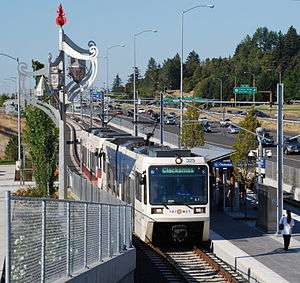
MAX Green Line

The MAX Green Line is a light rail line of the MAX Light Rail system in Portland, Oregon, United States that extends from downtown Portland to the eastside communities of Clackmas and Happy Valley. Owned and operated by TriMet, the line is 15 miles (24.1 km) long and serves 30 stations. It is the only line that shares parts of its alignment with all four of the other MAX lines; it shares the Banfield corridor with the Blue and Red lines and the Portland Transit Mall with the Orange and Yellow lines. A Frequent Service route, the Green Line is the second busiest in the system; it carried an average 21,630 riders per day on weekdays in May 2018.
Construction began in early 2007,[3] and the line opened on September 12, 2009.[4] The average daily ridership in June 2010 was 19,500,[5] increasing to 24,300 by April 2012.[6]
Project details
The Green Line runs over a combination of previously existing and new tracks. New tracks were built in two projects:
- Portland Mall Revitalization Project: Added light rail tracks to the Portland Transit Mall on both Fifth and Sixth Avenues between Portland State University and Union Station, along with tracks connecting this section to previously existing tracks on the west deck of the Steel Bridge, a total length of 1.8 miles (2.9 km). The project was born of the need to relieve congestion on the existing downtown Portland MAX alignment on Yamhill and Morrison Streets. The new Portland Mall tracks first came on August 30, 2009, by the MAX Yellow Line,[7] but the Green Line opened for service just 13 days later and also runs on this new alignment,[3] traveling the 2 miles from PSU to Rose Quarter in 17 minutes.
- I-205 Light Rail Project: Constructed a new 6.5-mile (10.5 km) alignment between Gateway Transit Center and a new transit center at Clackamas Town Center. The majority of this alignment uses the grade-separated, previously-unfinished I-205 Transitway built at the time Interstate 205 was constructed, in the late 1970s and early 1980s.[8]
Heading south from the Gateway/Northeast 99th Avenue Transit Center station, the alignment passes under the Burnside St., Stark St., Washington St., Main St. (pedestrian) and Market St. overpasses on the east side of the freeway, then crosses under the freeway between the Market St. and Division St. overpasses. It passes under the Division St. overpass before going over Powell Boulevard and then under the Holgate Boulevard overpass. It then passes under the Steele St. (ped.) overpass and over Harold St., Foster Rd., Woodstock Blvd., and Springwater Corridor. The line then crosses Johnson Creek before an at-grade crossing at Flavel St. The line passes over the intersection of 92nd Avenue and Crystal Springs Boulevard, then returns to grade before traveling above Johnson Creek Boulevard on a 1,400-foot-long overpass, the longest new structure on the alignment. South of Fuller Road station the line dips under the pre-existing Otty Road and Monterey Avenue overpasses, before terminating at the Clackamas Town Center Transit Center, near Sunnyside Road. Because of the extensive grade-separation, trains are able to travel the 6.5-mile (10.5 km) distance from Clackamas to Gateway in only 16 minutes. Much of this segment parallels the I-205 Bike Path.
Connecting the two new sections is the following previously existing section:
- Banfield-Burnside Eastside MAX: Between the west end of the Steel Bridge, at the edge of downtown Portland, and the Gateway Transit Center, the Green Line uses a portion of the original MAX alignment, completed in 1986 and which is now part of the Blue Line. The Red Line has also used the same section since its opening, in 2001.
Finances
The MAX Green Line project cost $575.7 million, $345.4 million of which was funded by the Federal Transit Administration.[9] The project received $32 million in funding from the American Recovery and Reinvestment Act of 2009, an amount already committed to the project by the federal government but made available so that TriMet could retire debt earlier.[9]
Future
Planned extension to Tigard and Tualatin
Southwest Corridor proposed route map | ||||||||||||||||||||||||||||||||||||||||||||||||||||||||||||||||||||||||||||||||||||||||||||||||||||||||||||||||||||||||||||||||||||||||||||||||||||||||||||||||||||||||||||||||||||||||||||||||
|---|---|---|---|---|---|---|---|---|---|---|---|---|---|---|---|---|---|---|---|---|---|---|---|---|---|---|---|---|---|---|---|---|---|---|---|---|---|---|---|---|---|---|---|---|---|---|---|---|---|---|---|---|---|---|---|---|---|---|---|---|---|---|---|---|---|---|---|---|---|---|---|---|---|---|---|---|---|---|---|---|---|---|---|---|---|---|---|---|---|---|---|---|---|---|---|---|---|---|---|---|---|---|---|---|---|---|---|---|---|---|---|---|---|---|---|---|---|---|---|---|---|---|---|---|---|---|---|---|---|---|---|---|---|---|---|---|---|---|---|---|---|---|---|---|---|---|---|---|---|---|---|---|---|---|---|---|---|---|---|---|---|---|---|---|---|---|---|---|---|---|---|---|---|---|---|---|---|---|---|---|---|---|---|---|---|---|---|---|---|---|---|---|
| ||||||||||||||||||||||||||||||||||||||||||||||||||||||||||||||||||||||||||||||||||||||||||||||||||||||||||||||||||||||||||||||||||||||||||||||||||||||||||||||||||||||||||||||||||||||||||||||||
A planned extension dubbed the Southwest Corridor light rail project will add 13 stations over a new 12-mile (19.3 km) span and connect downtown Portland to the cities of Tigard and Tualatin. The extension will start from the existing Green Line terminus at Portland State University and travel southwest, running through the center of Southwest Barbur Boulevard and terminating at Bridgeport Village.[10] Voters approved the light rail extension in a 2016 ballot measure.[11] At an estimated cost of $2.6 billion to $2.9 billion, the project will be submitted in a regional transportation funding measure that will be voted on in 2020. If approved, it is expected to begin service in 2027.
Other proposed extensions
The line may one day be extended south to Oregon City.[12][13] Such an extension was one of six corridors in Metro's High Capacity Transit System Plan designated as a "Next Phase Regional Priority Corridor,"[14] a second-level tier where "future HCT investment may be viable if recommended planning and policy actions are implemented."
Stations
| Station | Opened | Connections[15][16] | Park and ride[17] | Secure bike parking[18] |
|---|---|---|---|---|
| Portland Transit Mall | ||||
| PSU South/Southwest 6th and College Street (northbound) | 2009 | — | No | |
| PSU South/Southwest 5th and Jackson Street (southbound) | 2009 | — | No | |
| PSU Urban Center/Southwest 6th & Montgomery Street (northbound) | 2009 | — | No | |
| PSU Urban Center/Southwest 5th & Mill Street (southbound) | 2009 | — | No | |
| Southwest 6th & Madison Street (northbound) | 2009 | — | No | |
| City Hall/Southwest 5th & Jefferson Street (southbound) | 2009 | — | No | |
| Pioneer Courthouse/Southwest 6th (northbound) | 2009 | — | No | |
| Pioneer Place/Southwest 5th (northbound) | 2009 | — | No | |
| Southwest 6th & Pine Street (northbound) | 2009 | — | No | |
| Southwest 5th & Oak Street (southbound) | 2009 | — | No | |
| Northwest 6th & Davis Street (northbound) | 2009 | — | No | |
| Northwest 5th & Couch Street (southbound) | 2009 | — | No | |
| Union Station/Northwest 6th & Hoyt Street (northbound) | 2009 | — | No | |
| Union Station/Northwest 5th & Glisan Street (southbound) | 2009 | — | No | |
| Portland | ||||
| Rose Quarter Transit Center | 2009 | |
— | Yes |
| Convention Center | 2009 | |
— | No |
| Northeast 7th Avenue | 2009 | — | No | |
| Lloyd Center/Northeast 11th Avenue | 2009 | |
— | No |
| Hollywood/Northeast 42nd Avenue Transit Center | 2009 | |
— | Yes |
| Northeast 60th Avenue | 2009 | |
— | Yes |
| Northeast 82nd Avenue | 2009 | |
— | Yes |
| Gateway/Northeast 99th Avenue Transit Center | 2009 | |
690 spaces | Yes |
| Southeast Main Street | 2009 | 420 spaces | Yes | |
| Southeast Division Street | 2009 | — | Yes | |
| Southeast Powell Boulevard | 2009 | 391 spaces | Yes | |
| Southeast Holgate Boulevard | 2009 | 125 spaces | Yes | |
| Lents Town Center/Southeast Foster Road | 2009 | — | Yes | |
| Southeast Flavel Street | 2009 | — | Yes | |
| Clackamas | ||||
| Southeast Fuller Road | 2009 | 630 spaces | Yes | |
| Happy Valley | ||||
| Clackamas Town Center Transit Center | 2009 | 750 spaces | Yes | |
References
- ↑ "May 2018 Monthly Performance Report" (PDF). TriMet. Retrieved July 24, 2018.
- ↑ Pantell, Susan (December 2009). "Portland: New Green Line Light Rail Extension Opens". Light Rail Now. Retrieved September 1, 2018.
- 1 2 Redden, Jim (September 13, 2009). "Leaders heap praise on new MAX Green Line". Portland Tribune. Archived from the original on June 8, 2011. Retrieved 2014-05-13.
- ↑ Rivera, Dylan (September 13, 2009) [online date September 12, 2009]. "Riders pack MAX Green Line on first day of service". The Oregonian. Retrieved 2009-09-20.
- ↑ Monthly Performance Report (June 2010) (PDF). July 23, 2010. TriMet. Retrieved 2010-09-07.
- ↑ TriMet ridership continues to rise May 11, 2012. TriMet. Retrieved 2012-05-11.
- ↑ "New MAX line opens downtown". Portland Tribune. August 28, 2009. Archived from the original on June 8, 2011. Retrieved 2014-05-13.
- ↑ Redden, Jim (September 10, 2009) [updated October 30]. "After 35 years of waiting, TriMet's Green Line hits all the parties: Thousands ride new I-205 line that was born of a '70s freeway rebellion". Portland Tribune. Archived from the original on June 8, 2011. Retrieved 2014-05-13.
- 1 2 Carinci, Justin (May 8, 2009). "MAX green line gets $32 million". Daily Journal of Commerce. Retrieved August 21, 2012.
- ↑ "Southwest Corridor Light Rail Project Steering Committee Preferred Alternative Report" (PDF). Metro. August 20, 2018. Retrieved September 20, 2018.
- ↑ Hammond, Betsy (November 16, 2016). "Tigard voters say 'yes' to light rail -- by just 130 votes". The Oregonian. Archived from the original on September 20, 2018.
- ↑ Redden, Jim (August 20, 2009). "Cities fight to avoid being left at station". Portland Tribune. Retrieved 2014-05-13.
- ↑ https://trimet.org/pdfs/tip/tip.pdf (8.7M page vi)
- ↑ Regional High Capacity Transit System Plan 2035 - Summary Report. June 2010. Metro. http://library.oregonmetro.gov/files//hct_plan_june2010_web.pdf
- ↑ Rail System Map with transfers (PDF) (Map). TriMet. Retrieved July 25, 2018.
- ↑ Portland City Center and Transit Mall (PDF) (Map). TriMet. Retrieved July 30, 2018.
- ↑ "Park & Ride Locations". TriMet. Retrieved July 25, 2018.
- ↑ "Bike Parking". TriMet. Retrieved July 25, 2018.
External links
- MAX Green Line Project History (brief summary) on TriMet website.