MAX Red Line
.jpg)
The MAX Red Line is an airport rail link in Portland, Oregon, United States, operated by TriMet as part of the MAX Light Rail system. The line serves 29 stations from Beaverton Transit Center to Portland International Airport; it spans a section of track originally built for the Blue Line and an exclusive four-station, 5.5-mile (8.9 km) segment between Gateway/Northeast 99th Avenue Transit Center and the airport. The Red Line is the third-busiest service in the MAX system, carrying 19,840 average weekday passengers in May 2018.
Proposals for an airport light rail service surfaced in the mid-1980s and were fast-tracked in the 1990s following Portland International Airport's rapid expansion. Designed and built under a public–private partnership, the Airport MAX project was conceived from an unsolicited proposal from Bechtel in 1997. The extension began construction in 1999 and the line commenced service between downtown Portland and the airport on September 10, 2001. Amid strong ridership, service was extended west to Beaverton Transit Center in 2003. Existing plans intend to further extend the line west to Fair Complex/Hillsboro Airport station in 2023.
History
Background and partnership agreement
In 1975, during the initial design phase of Interstate 205, Portland city planners recommended downsizing the freeway and including a right-of-way for future transit, later fulfilled as the I-205 Transitway.[3] Amidst the Banfield light rail's construction in the mid-1980s, regional transit plans began calling for an extension to Portland International Airport,[4] which had been served by Tri-Met buses via Sandy Boulevard.[5] Throughout the 1990s, Portland International Airport expanded rapidly, with traffic more than doubling from six to fourteen million between 1990 and 2000.[2][6] Anticipating this growth, the Port of Portland embarked on a 20-year, $300-million airport expansion project in November 1991.[7] The first and second phases of construction, started in 1991,[8] rebuilt the existing passenger terminal and provisioned for a light rail station near the south end of the arrivals hall.[9][10] By 1994, parking lots had operated at 90 percent capacity as projections failed to meet the surge in demand. Growing traffic near the terminal entrances also became a problem, prompting the Port to fast-track its master plan and seek alternative solutions to alleviate congestion.[11]
Meanwhile, Tri-Met had been preoccupied with the construction of the Westside MAX extension and had plans to build the South–North line before it would consider extending light rail to the airport.[11] The South–North light rail project was subsequently defeated by voters in 1996.[12][13] In 1997, Bechtel submitted an unsolicited proposal to construct the airport extension.[3] After long deliberations, an agreement was made between Bechtel, the Port, and local governments. The agreement granted Bechtel the sole right to design and build the 5.5 mi (8.9 km) extension, and to fund a portion of the line in exchange for development rights to the 120-acre (485,622.8 m2) Portland International Center (PIC)—later renamed Cascade Station.[14] A decision was also made to accelerate the project by excluding Federal Transit Administration funds and instead pursue a public–private partnership.[3] Bechtel revised its original proposal to include Cascade Station in the light rail line in June 1998.[15] In October 1998, the Associated Builders and Contractors filed a petition in Multnomah County circuit court seeking a review of the agreements; they claimed that the contract may have violated Oregon procurement laws.[16] A judge ruled in favor of Tri-Met in December, declaring that the contract was awarded fairly.[17]
Funding
In July 1998, Tri-Met announced its projected cost of the extension to be $125 million (equivalent to $177 million in 2016 dollars), with additional costs raising the total to $182.7 million (equivalent to $258 million in 2016 dollars).[18] Under U.S. federal regulation, the Port of Portland was able to fund only the portion of rail located within its right-of-way and required approval from the Federal Aviation Administration (FAA).[19][20] As a solution, the Port proposed dividing the project's financing into three parts. The Port would be responsible for the 1.2-mile (1.9 km) segment from the airport terminal to Cascade Station. The next 1.4 miles (2.3 km) of track, which ran from the eastern end of airport property through Cascade Station, would be funded privately. The final 2.9-mile (4.7 km) segment along I-205 would be funded by local jurisdictions.[19]
Funding was divided among five entities. Of the $125 million in rail construction costs, Cascade Station Development (a private consortium of Bechtel and Trammell Crow) provided $28.2 million and an additional $13.1 million for the construction of the Airport Way interchange and streets within Cascade Station.[21] The Port of Portland contributed $28.3 million for construction and spent an additional $20 million on terminal and road improvements, drawing from a $3 ticket fee paid by travelers.[2][18] Delta Airlines, Reno Air, and United Airlines opposed the funding, arguing that the extension would only serve a small number of airline passengers.[22] The FAA gave its approval in May 1999.[23] Tri-Met provided $27.5 million for construction funded by $30 million in bonds.[2][18] It also supplied six new rail cars at a cost $6 million each.[21] Metro allocated $18 million for construction from a regional transportation fund originally set up for the Westside extension project.[2][18] The remaining $23 million came from tax increment bonds issued by the city of Portland.[3][2]
Construction and opening

Bechtel began construction on June 17, 1999, on a segment close to I-205 near the Columbia Slough.[21] Bridgework over the I-84 and I-205 interchange and the southbound lanes of I-205 near Airport Way commenced the following December.[24] To minimize freeway closures, a cast-in-place concrete pouring method was used to extended the bridges' spans in 16-foot (4.9 m) segments.[25] Owing to the I-205 Transitway revision in the 1970s, which accommodated a tunnel from Gateway/Northeast 99th Avenue Transit Center into the I-205 median in anticipation of a future busway (an idea later supplanted by light rail), work along the freeway segment was completed quickly. Further adding to the line's rapid completion, construction work did not displace any property owners; its impact limited to twenty parking spaces at Gateway Transit Center and several more along Airport Way.[21] Track work was contracted to Stacy and Witbeck and began in December 1999.[25][26] In order to meet the project's deadline, crews placed 3,200 feet (975.4 m) of single rail per day; tracks from Gateway Transit Center to the bridge over southbound I-205 were laid by July 2000.[27] Hoffman Construction, the company selected by the Port of Portland to expand the airport terminal, was tasked with building the $8.4 million airport station. With its glass-roofed shelters, the station was designed to complement the airport terminal's new drop-off canopy. Bechtel began end-to-end testing in March 2001, followed by Tri-Met in July.[26]
.jpg)
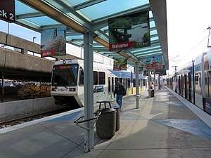
In September 2000, Tri-Met named the new extension the Red Line to differentiate it from the existing MAX service, which was renamed the Blue Line, between Hillsboro and Gresham.[28] The Red Line opened on September 10, 2001.[29] Celebrations slated for September 15–16 were canceled following the September 11 attacks,[5][30] and the airport was closed for three days as a result of a nation-wide ground stop.[31] The line's original western termini were Library/Southwest 9th Avenue and Galleria/Southwest 10th Avenue in downtown Portland, turning around at the 11th Avenue loop tracks.[32] The Tri-Met airport bus service was rerouted[n 2] and C-Tran moved its connection at Gateway Transit Center to Parkrose/Sumner Transit Center.[5] Although tested during trial runs,[26] Tri-Met opted to omit luggage racks from Red Line trains.[34] By November 2001, ridership averaged at 2,300 riders and peaked at 3,800 a day before Thanksgiving holiday weekend. The influx of riders prompted Tri-Met to deploy two-car trains on the line for the first time, which it had not previously planned to use until 2006.[35]
Later extension
In September 2003, Red Line service was extended farther west along the existing Blue Line tracks to Beaverton Transit Center in an effort increase capacity between Gateway Transit Center and Beaverton, and to provide a no-transfer airport connection for Westside MAX riders.[36] In March 2008, three trips in each direction during rush hour began operating between Beaverton Transit Center and Hatfield Government Center station to provide further additional capacity on the Blue Line amid growing ridership.[37]
Future plans
Extension to Fair Complex/Hillsboro Airport
On October 25, 2017, TriMet announced plans to extended the Red Line from Beaverton Transit Center to Fair Complex/Hillsboro Airport station in Hillsboro.[38] The $200-million project would create a no-transfer option from Portland International Airport to 10 additional stations on the Westside MAX and a transit link between the Portland and Hillsboro airports. On the east side, TriMet plans to add a second track on the existing single track segments between Gateway/Northeast 99th Avenue Transit Center and Parkrose/Sumner Transit Center, and between Mount Hood Avenue station and Portland International Airport station. To accommodate the extension, TriMet would purchase up to eight new light-rail vehicles and upgrade the Ruby Junction maintenance facility in Gresham.[39] In February 2018, engineering firm Parametrix was selected to complete the preliminary design.[40] If the project receives final approval, construction is expected to begin in 2021 and finish in 2023.[39]
In March 2018, the Hillsboro City Council authorized funds for a study to determine the effects of the extension on the current at-grade crossing at SW 185th Avenue, potentially paving the way for grade separation in the future.[41]
Route

The Red Line extension is 5.5 mi (8.9 km) long;[2] it utilizes the existing Blue Line tracks between Beaverton Transit Center and Gateway/Northeast 99th Avenue Transit Center, wherein the Green Line joins the shared alignment from Rose Quarter Transit Center.[42] At Gateway Transit Center, the Red Line branches southwest, makes a 180-degree loop, and heads north along the east side of Interstate 205.[2] Near Rocky Butte, the line enters a tunnel beneath the northbound lanes and exits along the median of the freeway.[21] Just south of the Columbia Slough, the Red Line turns north over southbound I-205 towards Cascade Station and curves northwest along the south side of Northeast Cascade Parkway,[43] which it follows then crosses just before Mount Hood Avenue station.[44] The line proceeds along the south side of Northeast Airport Way until it reaches its terminus at Portland International Airport station.[45]
Although much of the Red Line runs along a double-track railway, there are two segments on the 5.5-mile (8.9 km) extension that are single-track. The first segment starts at Gateway Transit Center and ends just east of exit 21B of southbound I-205. The other segment runs from south of the Northeast Airport Way and Northeast Airport Way Frontage Road intersection to just before the airport terminus.[46] There are plans to add a second track for both segments by 2023.[39]
Stations
The Red Line serves 25 stations originally built for the Blue Line. The airport extension opened in 2001 with four newly-built stations: Parkrose/Sumner Transit Center, Cascades, Mount Hood Avenue, and Portland International Airport.[2] The two stations serving Cascade Station (i.e.: Cascades and Mount Hood Avenue) were originally named East and West stations, respectively, until 2005.[47]
| Station | Opened | Transfers[48] | Connections[48][49][50] | Park and ride[51] | Secure bike parking[52] |
|---|---|---|---|---|---|
| Beaverton | |||||
| Beaverton Transit Center | 2003 | WES Commuter Rail |
— | Yes | |
| Portland | |||||
| Sunset Transit Center | 2003 | 622 spaces | Yes | ||
| Washington Park | 2003 | — | Yes | ||
| Goose Hollow/Southwest Jefferson Street | 2003 | — | No | ||
| Kings Hill/Southwest Salmon Street | 2003 | — | — | No | |
| Providence Park | 2003 | — | Yes | ||
| Library/Southwest 9th Avenue (eastbound) | 2001 | A Loop, B Loop, NS Line | — | No | |
| Galleria/Southwest 10th Avenue (westbound) | 2001 | — | No | ||
| Pioneer Square South (eastbound) | 2001 | Portland Transit Mall | — | No | |
| Pioneer Square North (westbound) | 2001 | — | No | ||
| Mall/Southwest 4th Avenue (eastbound) | 2001 | — | No | ||
| Mall/Southwest 5th Avenue (westbound) | 2001 | — | No | ||
| Yamhill District (eastbound) | 2001 | — | — | No | |
| Morrison/Southwest 3rd Avenue (westbound) | 2001 | — | — | No | |
| Oak Street/Southwest 1st Avenue | 2001 | — | — | No | |
| Skidmore Fountain | 2001 | — | — | No | |
| Old Town/Chinatown | 2001 | — | — | No | |
| Rose Quarter Transit Center | 2001 | — | Yes | ||
| Convention Center | 2001 | A Loop, B Loop |
— | No | |
| Northeast 7th Avenue | 2001 | A Loop | — | No | |
| Lloyd Center/Northeast 11th Avenue | 2001 | — | No | ||
| Hollywood/Northeast 42nd Avenue Transit Center | 2001 | — | Yes | ||
| Northeast 60th Avenue | 2001 | — | Yes | ||
| Northeast 82nd Avenue | 2001 | — | Yes | ||
| Gateway/Northeast 99th Avenue Transit Center | 2001 | 690 spaces | Yes | ||
| Parkrose/Sumner Transit Center | 2001 | — | 193 spaces | Yes | |
| Cascades | 2007 | — | — | — | No |
| Mount Hood Avenue | 2001 | — | — | — | No |
| Portland International Airport | 2001 | — | — | No | |
Service
The Red Line is a Frequent Service route; its trains operate for approximately 22 hours a day on a headway of 15 minutes most of the day, seven days a week.[53] From Monday to Sunday, the first train begins service going eastbound from Beaverton Transit Center to Portland International Airport. In the evenings, select westbound trains travel beyond Beaverton Transit Center; these trains change to Blue Line service upon arriving at Gateway Transit Center. The last three trains coming from Portland International Airport station turn into eastbound Blue Line trains at Gateway and terminate at Ruby Junction/East 197th Avenue station.[54]
Ridership
| Average weekday ridership, 2017 | ||
|---|---|---|
| Period | Passengers | %± |
| Jan–Mar | 19,633 | −5.0% |
| Apr–Jun | 19,690 | +0.3% |
| Jul–Sep | 21,690 | +10.2% |
| Oct–Dec | 20,497 | −5.5% |
| Source: TriMet[55] | ||
The Red Line is the third-busiest MAX service, carrying an average 19,840 riders on weekdays in May 2018.[1] It recorded an average 2,800 daily riders at the airport in September 2002, ahead of TriMet's first-year projections of 2,300.[56] The line's extension to Beaverton in 2003 increased weekday ridership by 49 percent on the westside corridor and 6 percent system-wide.[57] In 2009, ridership peaked at just over 9 million passengers.[58] In recent years, ridership has steadily fallen amid a system-wide drop;[59] 7.4 million boardings were recorded on the line in 2015 versus 8.2 million in 2012.[60][2]
See also
Notes
References
- 1 2 "May 2018 Monthly Performance Report" (PDF). TriMet. Retrieved July 24, 2018.
- 1 2 3 4 5 6 7 8 9 10 "Airport MAX Red Line" (PDF). TriMet. July 2016. Retrieved August 24, 2018.
- 1 2 3 4 Selinger, Philip (2015). "Making History: 45 Years of Transit in the Portland Region" (PDF). TriMet. p. 82. Retrieved July 26, 2018.
- ↑ Bodine, Harry (September 30, 1987). "Light rail expansion backed by officials". The Oregonian. p. B12.
- 1 2 3 Stewart, Bill (August 31, 2001). "Most Tri-Met fares rise Saturday, while route switches start Sept. 9". The Oregonian. p. B1.
- ↑ Gosling, Geoffrey D. (May 2012). Case Study Report: Portland MAX Airport Extension (PDF) (Report). Mineta Transportation Institute. Retrieved August 24, 2018.
- ↑ Sturtz, Paul (June 3, 1991). "Airport ready to take off on $300 million expansion". Portland Business Journal. p. 1A+.
- ↑ Hamburg, Ken (December 10, 1992). "Port of Portland speeds pace of airport terminal expansion". The Oregonian. p. E10.
- ↑ Mayes, Steve (April 11, 1991). "Portland's airport for the future only needs a $300 million ticket". The Oregonian. p. A1.
- ↑ Airport Max: A Case Study (PDF) (Report). BATIC Institute. Retrieved August 26, 2018.
- 1 2 Marks, Anita (February 25, 1994). "Airport struggles with runaway growth". Portland Business Journal. p. 1+.
- ↑ Middleton, William D.; Wolinsky, Julian (February 1999). "The urban rail outlook". Railway Age. Simmons-Boardman Publishing Corporation. p. G7.
- ↑ Oliver, Gordon; Hunsberger, Brent (November 7, 1996). "Tri-Met still wants that rail line to Clackamas County". The Oregonian. p. D1.
- ↑ Rose, Michael (December 19, 1997). "PDX light rail may lead to south-north line". Portland Business Journal. p. 1+.
- ↑ Rose, Michael (June 19, 1998). "Bechtel project tied to Portland's light rail". Puget Sound Business Journal. p. 26.
- ↑ Bjorhus, Jennifer (November 26, 1998). "Contractors battle Tri-Met on bid laws". The Oregonian. p. C1.
- ↑ Bjorhus, Jennifer (December 5, 1998). "Court tosses out suit against Tri-Met, Bechtel". The Oregonian. p. B1.
- 1 2 3 4 Oliver, Gordon (July 17, 1998). "Tri-Met puts price tag on airport line". The Oregonian. p. C01.
- 1 2 Ernico, Sheri (2012). Considering and Evaluating Airport Privatization (Report). 66. Transportation Research Board. ISSN 1935-9802. Retrieved August 23, 2018.
- ↑ Oliver, Gordon (October 9, 1998). "Port of Portland OKs light-rail agreement". The Oregonian. p. C01.
- 1 2 3 4 5 stewart, Bill (June 17, 1999). "Light-rail line to PDX starting to take shape". The Oregonian. p. B1.
- ↑ Gordon, Oliver (December 12, 1998). "3 airlines oppose light-rail money". The Oregonian. p. C1.
- ↑ Stewart, Bill (May 29, 1999). "Ruling: Port ticket fees can finance 'Air MAX'". The Oregonian. p. B1.
- ↑ Tomlinson, Stuart (December 3, 1999). "Construction detours bottleneck I-84 traffic". The Oregonian. p. C3.
- 1 2 Stewart, Bill (December 17, 1999). "Don't look up, but MAX bridge going in over I-205; strict safety measures are in place to protect motorists, and as the span is built, tracks will start going in on Airport Way". The Oregonian. p. A1.
- 1 2 3 Stewart, Bill (July 10, 2000). "Airport's MAX station will be special". The Oregonian. p. E4.
- ↑ Stewart, Bill (June 12, 2000). "Workers are busy making tracks toward Airport MAX 2001 deadline". The Oregonian. p. E4.
- ↑ Stewart, Bill (September 21, 2000). "Local colors roll out: Tri-Met designates the Blue, Red and Yellow lines". The Oregonian. pp. E1, E10.
- ↑ Oliver, Gordon (September 21, 2001). "Unknowns cloud PDX's future". The Oregonian. p. D1.
- ↑ "History cancels PDX party". The Oregonian. September 15, 2001. p. D8.
- ↑ Rose, Joseph (September 17, 2001). "Even anti-noise advocates happy to hear airplanes again". The Oregonian. p. E6.
- ↑ Stewart, Bill (September 7, 2001). "Airport MAX rolls out Monday". The Oregonian. p. B1.
- 1 2 Theen, Andrew (August 30, 2018). "New TriMet bus, MAX additions create all-night service to PDX". The Oregonian. Archived from the original on September 16, 2018.
- ↑ "MAX Red Line runs: Every 15 minutes, seven days a week". The Oregonian. September 11, 2001. p. A12.
- ↑ "About town riders keep Airport MAX busy Thanksgiving weekend". The Oregonian. November 27, 2001. p. D2.
- ↑ Leeson, Fred (August 27, 2003). "MAX fares increase, direct service from Beaverton to PDX starts". The Oregonian. p. D2.
- ↑ "TriMet extends rush-hour MAX trains between Hillsboro, PDX". Beaverton Valley Times. March 3, 2008. Archived from the original on May 11, 2008. Retrieved November 1, 2015.
- ↑ Howard, John William (October 25, 2017). "TriMet considering expansion of MAX Red Line to county fairgrounds". Hillsboro Tribune. Archived from the original on October 10, 2018. Retrieved August 22, 2018.
- 1 2 3 "MAX Red Line Improvements Project". TriMet. Archived from the original on August 23, 2018. Retrieved August 2, 2018.
- ↑ "Parametrix to complete preliminary design for MAX Red Line extension". Parametrix. February 18, 2018. Archived from the original on September 13, 2018. Retrieved September 6, 2018.
- ↑ Pot, Justin (March 16, 2018). "The MAX Red Line will extend to the Fairgrounds; what's that mean for 185th Avenue traffic?". Hillsboro Signal. Archived from the original on September 13, 2018. Retrieved August 22, 2018.
- ↑ TriMet System map (PDF) (Map). TriMet. Retrieved July 25, 2018.
- ↑ "Stop ID 10575 - Cascades MAX Station". TriMet. Retrieved September 7, 2018.
- ↑ "Stop ID 10577 - Mt Hood MAX Station". TriMet. Retrieved September 7, 2018.
- ↑ "Stop ID 10579 - Portland Int'l Airport MAX Station". TriMet. Retrieved September 7, 2018.
- ↑ Weber, Erik (September 19, 2012). "Portland provides some urban inspiration for DC". Greater Greater Washington. Archived from the original on September 16, 2018. Retrieved September 6, 2018.
- ↑ Amendments to the Cascade Station/Portland International Center Plan District (Report). City of Portland Bureau of Planning. April 2005. p. 11. Retrieved September 18, 2018.
- 1 2 Rail System Map with transfers (PDF) (Map). TriMet. Retrieved July 25, 2018.
- ↑ Portland City Center and Transit Mall (PDF) (Map). TriMet. Retrieved July 30, 2018.
- ↑ "Maps + Schedules - Portland Streetcar". Portland Streetcar. Retrieved October 11, 2018.
- ↑ "Park & Ride Locations". TriMet. Retrieved July 25, 2018.
- ↑ "Bike Parking". TriMet. Retrieved July 25, 2018.
- ↑ "Frequent Service" (PDF). TriMet. Retrieved August 6, 2018.
- ↑ "MAX Red Line Schedules". TriMet. Retrieved September 13, 2018.
- ↑ "Monthly reports". TriMet. Retrieved August 3, 2018.
- ↑ Leeson, Fred (September 9, 2002). "Air travelers find MAX a deal". The Oregonian. p. E1.
- ↑ River, Dylan (September 6, 2009). "MAX: More than the sum of its parts". The Oregonian.
- ↑ "Infrastructure Case Study: Portland Airport MAX Red Line" (PDF). Bipartisan Policy Center. October 2016. Retrieved September 13, 2018.
- ↑ Keizur, Christopher (June 12, 2017). "Safe travels?". Portland Tribune. Archived from the original on August 4, 2018. Retrieved August 3, 2018.
- ↑ "Airport MAX: Red Line" (PDF). TriMet. August 2012. Retrieved September 13, 2018.