Měcholupy (Louny District)
| Měcholupy | ||
|---|---|---|
| Municipality | ||
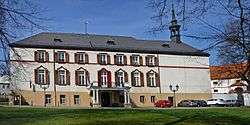 Měcholupy Castle | ||
| ||
 Měcholupy | ||
| Coordinates: 50°15′56″N 13°32′26″E / 50.26556°N 13.54056°ECoordinates: 50°15′56″N 13°32′26″E / 50.26556°N 13.54056°E | ||
| Country |
| |
| Region | Ústí nad Labem | |
| District | Louny | |
| Area | ||
| • Total | 29.12 km2 (11.24 sq mi) | |
| Elevation | 253 m (830 ft) | |
| Population (2006) | ||
| • Total | 1,057 | |
| • Density | 36/km2 (94/sq mi) | |
| Postal code | 439 31 | |
| Website | http://www.mecholupy-sc.cz/ | |
Měcholupy (German: Michelob) is a village and municipality (obec) in Louny District in the Ústí nad Labem Region of the Czech Republic.
Geography
Měcholupy is located on the Blšanka river, a tributary of the Ohře. It lies approximately 21 kilometres (13 mi) south-west of Louny, 57 km (35 mi) south-west of Ústí nad Labem, and 66 km (41 mi) west of Prague. In the area, several remnants of the Czechoslovak border fortifications can be found.
The municipality comprises the cadastral communities of Měcholupy proper, Milošice, Velká Černoc, and Želeč.
History
The settlement was first mentioned in a 1295 deed, when the surrounding estates were held by Bohemian nobles. Temporarily seized by the Bohemian Crown after the Battle of White Mountain in 1620, the lands later were acquired by the Kolowrat and Lobkowicz dynasties. Měcholupy Castle was erected from 1690 onwards in a Baroque style.
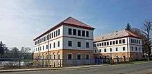
With Bohemia, Měcholupy became part of the Austrian Empire in 1804. A newly established brewery was documented in 1827 which was acquired by Anton Dreher in 1860. A larger Dreher brewery was erected in 1872; three years later, Měcholupy received the status of a market town. Since 1896, Michelob is a beer brand of Anheuser-Busch.
References
External links
| Wikimedia Commons has media related to Měcholupy (Louny District). |
- Municipal website (in Czech)