Petrohrad
| Petrohrad | |||
|---|---|---|---|
| Municipality | |||
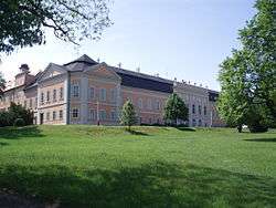 Castle in the village | |||
| |||
 Petrohrad | |||
| Coordinates: 50°7′37″N 13°26′28″E / 50.12694°N 13.44111°ECoordinates: 50°7′37″N 13°26′28″E / 50.12694°N 13.44111°E | |||
| Country |
| ||
| Region | Ústí nad Labem | ||
| District | Louny | ||
| Area | |||
| • Total | 18.52 km2 (7.15 sq mi) | ||
| Elevation | 365 m (1,198 ft) | ||
| Population (2006) | |||
| • Total | 688 | ||
| • Density | 37/km2 (96/sq mi) | ||
| Postal code | 439 83 to 439 85 | ||
| Website | http://www.petrohrad-obec.cz | ||

Petrohrad (German: Petersburg) is a village and municipality (obec) in Louny District in the Ústí nad Labem Region of the Czech Republic.
The municipality covers an area of 18.52 square kilometres (7.15 sq mi), and has a population of 688 (as at 3 July 2006).
Petrohrad lies approximately 36 kilometres (22 mi) south-west of Louny, 73 km (45 mi) south-west of Ústí nad Labem, and 71 km (44 mi) west of Prague.
References
This article is issued from
Wikipedia.
The text is licensed under Creative Commons - Attribution - Sharealike.
Additional terms may apply for the media files.