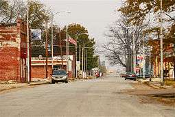
Luxora, Arkansas
| Luxora, Arkansas | |
|---|---|
| City | |
 | |
 Location of Luxora in Mississippi County, Arkansas. | |
| Coordinates: 35°45′25″N 89°55′47″W / 35.75694°N 89.92972°WCoordinates: 35°45′25″N 89°55′47″W / 35.75694°N 89.92972°W | |
| Country | United States |
| State | Arkansas |
| County | Mississippi |
| Area[1] | |
| • Total | 0.85 sq mi (2.21 km2) |
| • Land | 0.85 sq mi (2.21 km2) |
| • Water | 0.00 sq mi (0.00 km2) |
| Elevation | 246 ft (75 m) |
| Population (2010) | |
| • Total | 1,178 |
| • Estimate (2017)[2] | 1,060 |
| • Density | 1,244.13/sq mi (480.22/km2) |
| Time zone | UTC-6 (Central (CST)) |
| • Summer (DST) | UTC-5 (CDT) |
| ZIP code | 72358 |
| Area code(s) | 870 |
| FIPS code | 05-42170 |
| GNIS feature ID | 0058107 |
Luxora is a city[3] in Mississippi County, Arkansas, United States. The population was 1,178 at the 2010 census.
Geography
Luxora is located at 35°45′25″N 89°55′47″W / 35.75694°N 89.92972°W (35.756954, -89.929616).[4]
According to the United States Census Bureau, the town has a total area of 2.3 km² (0.9 mi²), all land.
Demographics
| Historical population | |||
|---|---|---|---|
| Census | Pop. | %± | |
| 1900 | 943 | — | |
| 1910 | 677 | −28.2% | |
| 1920 | 1,179 | 74.2% | |
| 1930 | 1,074 | −8.9% | |
| 1940 | 1,258 | 17.1% | |
| 1950 | 1,302 | 3.5% | |
| 1960 | 1,236 | −5.1% | |
| 1970 | 1,566 | 26.7% | |
| 1980 | 1,739 | 11.0% | |
| 1990 | 1,338 | −23.1% | |
| 2000 | 1,317 | −1.6% | |
| 2010 | 1,178 | −10.6% | |
| Est. 2017 | 1,060 | [2] | −10.0% |
| U.S. Decennial Census[5] | |||
As of the 2010 United States Census, there were 1,178 people residing in the town. The racial makeup of the town was 60.8% Black, 33.1% White, 0.5% Native American and 1.0% from two or more races. 4.6% were Hispanic or Latino of any race.
At the 2000 census,[6] there were 1,317 people, 477 households and 352 families residing in the town. The population density was 584.5/km² (1,514.5/mi²). There were 537 housing units at an average density of 238.3/km² (617.5/mi²). The racial makeup of the town was 40.93% White, 56.04% Black or African American, 0.08% Native American, 1.97% from other races, and 0.99% from two or more races. 2.73% of the population were Hispanic or Latino of any race.
There were 477 households of which 38.6% had children under the age of 18 living with them, 43.0% were married couples living together, 26.0% had a female householder with no husband present, and 26.0% were non-families. 23.9% of all households were made up of individuals and 11.1% had someone living alone who was 65 years of age or older. The average household size was 2.76 and the average family size was 3.29.
Age distribution was 34.8% under the age of 18, 7.6% from 18 to 24, 24.8% from 25 to 44, 21.1% from 45 to 64, and 11.7% who were 65 years of age or older. The median age was 31 years. For every 100 females, there were 87.1 males. For every 100 females age 18 and over, there were 78.2 males.
The median household income was $20,304, and the median family income was $23,906. Males had a median income of $22,375 versus $18,698 for females. The per capita income for the town was $9,060. About 30.7% of families and 32.4% of the population were below the poverty line, including 37.7% of those under age 18 and 30.3% of those age 65 or over.
Education
Public education for elementary and secondary students is provided by the Rivercrest School District (formerly the Southern Mississippi County School District), which includes the Southern Mississippi County Elementary School at Luxora (prekindergarten through grade 4). Students graduate from Rivercrest High School located near Wilson.
On July 1, 1986, the Luxora School District consolidated into the Southern Mississippi County School District.[7]
References
- ↑ "2017 U.S. Gazetteer Files". United States Census Bureau. Retrieved Aug 22, 2018.
- 1 2 "Population and Housing Unit Estimates". Retrieved March 24, 2018.
- ↑ Local.Arkansas.gov - Luxora, retrieved September 3, 2012
- ↑ "US Gazetteer files: 2010, 2000, and 1990". United States Census Bureau. 2011-02-12. Retrieved 2011-04-23.
- ↑ "Census of Population and Housing". Census.gov. Retrieved June 4, 2015.
- ↑ "American FactFinder". United States Census Bureau. Retrieved 2008-01-31.
- ↑ "ConsolidationAnnex_from_1983.xls." Arkansas Department of Education. Retrieved on July 31, 2017.
Municipalities and communities of Mississippi County, Arkansas, United States | ||
|---|---|---|
| Cities | 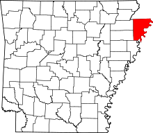 | |
| Towns | ||
| Unincorporated communities | ||
| Footnotes | ‡This populated place also has portions in an adjacent county or counties | |