Driver, Arkansas
| Driver, Arkansas | |
|---|---|
| Unincorporated community | |
 Driver, Arkansas  Driver, Arkansas | |
| Coordinates: 35°36′44″N 90°00′43″W / 35.61222°N 90.01194°WCoordinates: 35°36′44″N 90°00′43″W / 35.61222°N 90.01194°W | |
| Country | United States |
| State | Arkansas |
| County | Mississippi |
| Elevation | 236 ft (72 m) |
| Time zone | UTC-6 (Central (CST)) |
| • Summer (DST) | UTC-5 (CDT) |
| ZIP code | 72329 |
| Area code(s) | 870 |
| GNIS feature ID | 57678[1] |
Driver is an unincorporated community in Mississippi County, Arkansas, United States. Driver is located at the intersection of U.S. Route 61 and Arkansas Highway 119, 3.5 miles (5.6 km) north-northeast of Wilson.[2]
References
- ↑ U.S. Geological Survey Geographic Names Information System: Driver, Arkansas
- ↑ ZIP Code Lookup Archived September 14, 2012, at the Wayback Machine.
Municipalities and communities of Mississippi County, Arkansas, United States | ||
|---|---|---|
| Cities | 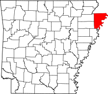 | |
| Towns | ||
| Unincorporated communities | ||
| Footnotes | ‡This populated place also has portions in an adjacent county or counties | |
This article is issued from
Wikipedia.
The text is licensed under Creative Commons - Attribution - Sharealike.
Additional terms may apply for the media files.