Calumet, Arkansas
| Calumet, Arkansas | |
|---|---|
| Unincorporated community | |
 Calumet, Arkansas  Calumet, Arkansas | |
| Coordinates: 35°58′54″N 89°59′10″W / 35.98167°N 89.98611°WCoordinates: 35°58′54″N 89°59′10″W / 35.98167°N 89.98611°W | |
| Country | United States |
| State | Arkansas |
| County | Mississippi |
| Elevation | 246 ft (75 m) |
| Time zone | UTC-6 (Central (CST)) |
| • Summer (DST) | UTC-5 (CDT) |
| Area code(s) | 870 |
| GNIS feature ID | 56948[1] |
Calumet is an unincorporated community in Mississippi County, Arkansas, United States. Calumet is located at the junction of Arkansas highways 151 and 181 on the northeast border of Gosnell.[2]
References
- ↑ "Calumet". Geographic Names Information System. United States Geological Survey.
- ↑ Mississippi County, Arkansas General Highway Map (PDF) (Map). Arkansas State Highway and Transportation Department. 2010. Retrieved June 24, 2012.
Municipalities and communities of Mississippi County, Arkansas, United States | ||
|---|---|---|
| Cities | 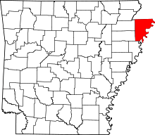 | |
| Towns | ||
| Unincorporated communities | ||
| Footnotes | ‡This populated place also has portions in an adjacent county or counties | |
This article is issued from
Wikipedia.
The text is licensed under Creative Commons - Attribution - Sharealike.
Additional terms may apply for the media files.