Floodway, Arkansas
| Floodway, Arkansas | |
|---|---|
| Unincorporated community | |
 Floodway, Arkansas  Floodway, Arkansas | |
| Coordinates: 35°46′43″N 90°10′41″W / 35.77861°N 90.17806°WCoordinates: 35°46′43″N 90°10′41″W / 35.77861°N 90.17806°W | |
| Country | United States |
| State | Arkansas |
| County | Mississippi |
| Elevation | 236 ft (72 m) |
| Time zone | UTC-6 (Central (CST)) |
| • Summer (DST) | UTC-5 (CDT) |
| Area code(s) | 870 |
| GNIS feature ID | 61865[1] |
Floodway is an unincorporated community in Mississippi County, Arkansas, United States. Floodway is located at the junction of Arkansas highways 77 and 158, 7 miles (11 km) south of Manila.[2]
Floodway has been noted for its unusual place name.[3]
References
- ↑ U.S. Geological Survey Geographic Names Information System: Floodway, Arkansas
- ↑ Mississippi County, Arkansas General Highway Map (PDF) (Map). Arkansas State Highway and Transportation Department. 2010. Retrieved October 13, 2011.
- ↑ Thompson, George E. (1 July 2009). You Live Where?: Interesting and Unusual Facts about where We Live. iUniverse. p. 7. ISBN 978-1-4401-3421-0.
Municipalities and communities of Mississippi County, Arkansas, United States | ||
|---|---|---|
| Cities | 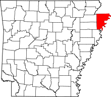 | |
| Towns | ||
| Unincorporated communities | ||
| Footnotes | ‡This populated place also has portions in an adjacent county or counties | |
This article is issued from
Wikipedia.
The text is licensed under Creative Commons - Attribution - Sharealike.
Additional terms may apply for the media files.