Lumphat District
| Lumphat លំផាត់ | |
|---|---|
| District | |
 Location of Lumphat in Ratanakiri | |
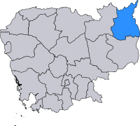 Location of Ratanakiri in Cambodia | |
| Country | Cambodia |
| Province | Ratanakiri |
| Communes | Chey Otdam, Ka Laeng, La Bang Muoy, La Bang Pir, Pa Tang, Seda |
| Population (1998) | |
| • Total | 10,301 |
| Time zone | UTC+7 (Cambodia time) |
| District code | 1605 |
Lumphat (Khmer: លំផាត់) is a district in Ratanakiri Province, north-east Cambodia. In 1998, it had a population of 10,301.[1]
Lomphat, the former capital of Ratanakiri, is located in the district on the Srepok River. The town is home to fewer than 800 people. The district gives its name to the Lomphat Wildlife Sanctuary, a preservation area for the many unique species indigenous to Northeast Cambodia.
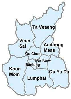
Administration
The district is subdivided into six communes (khum),[2] which are further subdivided into 26 villages (phum).
| Commune | Villages[1][3] | Population (1998)[1] |
|---|---|---|
| Chey Otdam | Ou Kan, Srae Chhuk, Sam Kha, Dei Lou, Thmei, Lumphat | 2,832 |
| Ka Laeng | Says, Ka Laeng, Ka Nang Ket | 1,026 |
| La Bang Muoy | Kam Phlenh, Ka Tueng, Ka Tieng, Ka Lang | 912 |
| La Bang Pir | Ka Tieng, Ka Chanh | 670 |
| Pa Tang (Ba Tang) | Ul, Pruok, Pa Tang, Chang Rea | 1,964 |
| Seda | Thmei, Pa Tat, Kaeng San, Sakmotr Leu, Poum, Nang Hai, Sakmotr Kraom | 2,897 |
References
- 1 2 3 "Final Population Totals, Rotanak Kiri Province, 1998" Archived 2008-10-29 at the Wayback Machine.. Cambodia National Institute of Statistics. Accessed June 6, 2008.
- ↑ National Institute of Statistics
- ↑ "Ratanak Kiri Province" Archived 2008-06-02 at the Wayback Machine.. Cambodia National Institute of Statistics. Accessed June 6, 2008.
Capital city: Banlung | |||||||||||||||||||
| Landmarks | 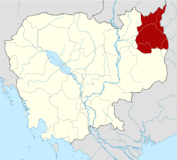 | ||||||||||||||||||
| Administrative divisions |
| ||||||||||||||||||
Coordinates: 13°25′N 107°0′E / 13.417°N 107.000°E
This article is issued from
Wikipedia.
The text is licensed under Creative Commons - Attribution - Sharealike.
Additional terms may apply for the media files.