Llangynidr
| Llangynidr | |
|---|---|
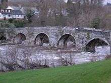 Llangynidr Bridge over the River Usk in winter | |
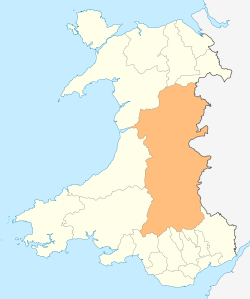
 Llangynidr Llangynidr shown within Powys | |
| Population | 1,036 (2011)[1] |
| OS grid reference | SO153191 |
| Principal area | |
| Ceremonial county | |
| Country | Wales |
| Sovereign state | United Kingdom |
| Post town | Crickhowell |
| Postcode district | NP8 |
| Dialling code | 01874 |
| Police | Dyfed-Powys |
| Fire | Mid and West Wales |
| Ambulance | Welsh |
| EU Parliament | Wales |
| UK Parliament | |
Llangynidr is a village, community and electoral ward in Powys, Wales, about 4 miles (6.4 km) west of Crickhowell and 9 miles (14.5 km) south-east of Brecon. The River Usk flows through the village as does the Monmouthshire and Brecon Canal. It is in the historic county of Brecknockshire.
The village
The village is located four miles west of Crickhowell and nine miles southeast of Brecon, beside the River Usk and the Monmouthshire and Brecon Canal. It is situated on the B4558 just to the south of where this road diverges from the A40 trunk road.[2] The stone bridge across the river dates from approximately 1700 and is a Grade I listed building.[3] The canal has five locks and an aqueduct in the vicinity of the village.[4]
The village is notionally divided into Upper and Lower Llangynidr. The remains of what may be a medieval reeve's house have been discovered in the course of archaeological excavations in the centre of the village.[5] The village has two public houses, a village shop and a primary school.[6][7]
History
Sir William Herbert, Knight of Raglan Castle, was granted the manors of Tretower Castle and Crickhowell just after the accession of Edward IV in 1442. At that time this village was part of the manor of Tretower.[8]
The land was then in the ownership of the Earls of Worcester until the nineteenth and early twentieth century when much of Llangynidr was part of the Glanusk Park estate.[8]
On the moors to the southeast of the village lies the Chartist Cave, the name of which derives from 1839 when Chartist rebels used the cave to stockpile weapons in advance of their march on Newport. There is a plaque at the entrance of the cave commemorating their actions.[9]
References
- ↑ "Ward/Community population 2011". Retrieved 12 November 2015.
- ↑ "Ordnance Survey map 141: Brecon". One inch series. Ordnance Survey. Missing or empty
|url=(help);|access-date=requires|url=(help) - ↑ "Llangynidr Bridge (partly in Llanfihangel Cwmdu with Bwlch and Cathedine community), Llangynidr". British Listed Buildings. Retrieved 28 April 2016.
- ↑ Nicholson (2006). Nicholson Guides Vol 4: Four Counties and the Welsh Canals. Harper Collins Publishers. ISBN 0-00-721112-0.
- ↑ Anthony, Michael. Persondy field, Llangynidr: excavations, September 2002. Hanes: newsletter of the Brecknock History Forum, No 11 (May 2003), 3-4.
- ↑ "Llangynidr". Brecon Beacons Holiday Cottages. Retrieved 28 April 2016.
- ↑ "Welcome to Llangynidr Primary School". Retrieved 28 April 2016.
- 1 2 "An Introduction to the History of Llangynidr" Dorethea Watkins 1986 Langynidr Local History Society
- ↑ "Chartist's Cave". Caves of South Wales. Retrieved 28 April 2016.
External links
| Wikimedia Commons has media related to Llangynidr. |
Further reading
- Shadows in a Landscape (Llangynidr Local History Society, 2000)
- Stories Behind the Stone Cross (Llangynidr Local History Society, 2014)