Talybont-on-Usk
Talybont-on-Usk
| |
|---|---|
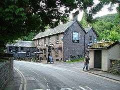 The White Hart Inn | |
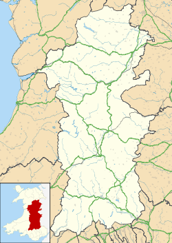 Talybont-on-Usk Talybont-on-Usk shown within Powys | |
| Population | 719 (2011)[1] |
| OS grid reference | SO111226 |
| Community |
|
| Principal area | |
| Ceremonial county | |
| Country | Wales |
| Sovereign state | United Kingdom |
| Post town | BRECON |
| Postcode district | LD3 |
| Dialling code | 01874 |
| Police | Dyfed-Powys |
| Fire | Mid and West Wales |
| Ambulance | Welsh |
| EU Parliament | Wales |
| UK Parliament | |
| Welsh Assembly | |
Talybont-on-Usk (Welsh: Tal-y-bont ar Wysg) is a village and community in Powys, Wales, in the historic county of Brecknockshire (Breconshire). It lies on both the River Caerfanell and the Monmouthshire and Brecon Canal. (In fact it is about a mile from the River Usk) It had a population in 2001 of 743,[2] reducing to 719 at the 2011 Census.
History
Allt yr Esgair is a steep-sided hill to the north east of Talybont, and has an Iron Age settlement on the summit. There are other Iron Age and Bronze Age sites in the vicinity and a Roman road flanks the slopes of Allt yr Esgair. A small castle was built at Pencelli during the Norman invasion and this was later replaced by the sixteenth century Pencelli House. The canal was built around 1800 to transport lime, coal and iron to Newport. There are some lime kilns to the east of the village and a tramroad was built to transport limestone from the crags above.[3]
The village
The village is located on the B4558 road about six miles southeast of Brecon and eight miles northwest of Crickhowell. It is a mile from the River Usk and on the Monmouthshire and Brecon Canal and is connected to the A40 trunk road on the other side of the Usk by a short section of unclassified road.[4] The village has a shop and several pubs.[5] The valley one mile south of the village is dammed to form the Talybont Reservoir. This has a 380 metres (1,250 ft) dam and there are forest trails in its vicinity.[6] Talybont-on-Usk is a popular place for walkers and offers the Henry Vaughan walk through the nearby countryside where the 18th century poet once lived.[7] Another walk can be followed along the line of the former Brinore Tramroad which runs south from the canalside wharf in the village around the western flanks of Y Wenallt and Tor y Foel before heading to Trefil via the head of the Dyffryn Crawnon valley.[8]
Governance
A Talybont-on Usk electoral ward exists, covering Talybont-on Usk and the neighbouring communities of Glyn Tarell and Llanfrynach. The population of this ward at the 2011 Census was 1,923.[9] It elects one councillor to Powys County Council.
Talybont-on-Usk Community Council represents the community at the local level. Up to nine community councillors are elected or co-opted to the council.[10]
Notable residents
- Fred Miller (born 1873; date of death unknown), Welsh international rugby player, born in Talybont-on-Usk.
- David Lewis, 1st Baron Brecon, PC (1905–1976), a Welsh businessman and Conservative politician[11]
- Roland Mathias (1915-2007), poet and short story writer.
References
- ↑ "Community population 2011". Retrieved 14 November 2015.
- ↑ Office for National Statistics : Census 2001 : Parish Headcounts : Powys Retrieved 2009-11-25
- ↑ "Talybont history". Talybont-on-Usk. Retrieved 28 April 2016.
- ↑ "Ordnance Survey map 141: Brecon" (Map). One inch series. Ordnance Survey.
- ↑ Dragicevich, Peter; O'Carroll, Etain; Smith, Helena (2013). Lonely Planet Wales. Lonely Planet Publications. p. 219. ISBN 978-1-74321-816-7.
- ↑ "A walk beside Talybont Reservoir and in Talybont Forest". Brecon Beacons National Park. Archived from the original on 26 November 2015. Retrieved 28 April 2016.
- ↑ Brecon Beacons National Park Retrieved 2015-06-15
- ↑ "Brinore Tramroad". Retrieved 28 April 2016.
- ↑ "Ward population 2011". Retrieved 14 November 2015.
- ↑ "Members of the Community Council". Talybont-on-Usk Community Council. Retrieved 13 October 2018.
- ↑ Kidd, Charles; Williamson, David, eds. (1990). Debrett's Peerage and Baronetage. New York: St. Martin's Press.
External links
| Wikimedia Commons has media related to Talybont-on-Usk. |
- www.geograph.co.uk : photos of Talybont-on-Usk and surrounding area
- Map sources for Talybont-on-Usk
- Talybont-on-Usk
- Friends of Talybont Reservoir