Listed buildings in Odense Municipality
This is a list of listed buildings in Odense Municipality, Denmark.
- Note:: This list is incomplete. A complete list of listed buildings in Odense Municipality can be found on Danish Wikipedia.
The list
| Listing name | Image | Location | Coordinates | Description |
|---|---|---|---|---|
| Albani Torv 11 (Ruinen på I. Vilh. Werners Plads) | Albani Torv 11, 5000 Odense C | 55°23′47.53″N 10°23′22.15″E / 55.3965361°N 10.3894861°E | The medieval part of building from c. 1500, It was originally located at Overgade 3 but has been moved[1] | |
| Bispens Lysthus | Filosofgangen 10, 5000 Odense C | 55°23′34.33″N 10°23′8.67″E / 55.3928694°N 10.3857417°E | [2] | |
| Blangstedgaard | Blangstedgårds Allé 92, 5220 Odense SØ | 55°22′52.64″N 10°26′44.08″E / 55.3812889°N 10.4455778°E | Agerumsladen . Barn from the 18th century[3] | |
| Fraugdegård | 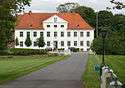 | Fraugdegårds Allé 7, 5220 Odense SØ | 55°16′9.19″N 9°53′29.39″E / 55.2692194°N 9.8914972°E | Main building from c. c. 1588[4] |
| Fruens Bøge Station | 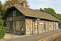 | Fruens Bøge Skov 4, 5250 Odense SV | 55°22′11.02″N 10°22′39.51″E / 55.3697278°N 10.3776417°E | Station building from 1876 by H.A.W. Haugsted[5] |
| Fruens Bøge Skov 4, 5250 Odense SV | 55°22′11.02″N 10°22′39.51″E / 55.3697278°N 10.3776417°E | Warehouse from 1876 by H.A.W. Haugsted[6] | ||
| Havnetoldkammeret | 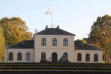 | Londongade 4, 5000 Odense C | 55°24′22.53″N 10°22′59.96″E / 55.4062583°N 10.3833222°E | Custom house from1834 by Jørgen Hansen Koch as well as the side wing and building on Strandgade from 1845[7] |
| Odense Latin School | Frue Kirkestræde 10, 5000 Odense C | 55°23′51.44″N 10°23′42.38″E / 55.3976222°N 10.3951056°E | School building from the 17th century on a foundation from the Middle Ages which was adapted in 1860 and restored in 1955 by Axel Jacobsen[8] | |
| Odense Palace | 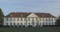 | Nørregade 36, 5000 Odense C | 55°23′54.5″N 10°23′15.53″E / 55.398472°N 10.3876472°E | Three-winged building complex[9] |
| Sankt Knuds Kloster | 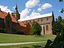 | Klosterbakken 2, 5000 Odense C | 55°23′41.51″N 10°23′18.97″E / 55.3948639°N 10.3886028°E | Monestery[10] |
| Thriges Kraftcentral |  | Haubergsvej 1, 5000 Odense C | 55°24′22.78″N 10°23′18.59″E / 55.4063278°N 10.3884972°E | Power station from 1915-16 by Niels Jacobsen[11] |
References
- ↑ https://www.kulturarv.dk/fbb/sagvis.pub?sag=2340224
- ↑ https://www.kulturarv.dk/fbb/sagvis.pub?sag=2340151
- ↑ https://www.kulturarv.dk/fbb/sagvis.pub?sag=2340206
- ↑ https://www.kulturarv.dk/fbb/sagvis.pub?sag=2340218
- ↑ https://www.kulturarv.dk/fbb/sagvis.pub?sag=2340101
- ↑ https://www.kulturarv.dk/fbb/sagvis.pub?sag=2340101
- ↑ https://www.kulturarv.dk/fbb/sagvis.pub?sag=10831629
- ↑ https://www.kulturarv.dk/fbb/sagvis.pub?sag=2340149
- ↑ https://www.kulturarv.dk/fbb/sagvis.pub?sag=2340247
- ↑ https://www.kulturarv.dk/fbb/sagvis.pub?sag=2340119
- ↑ https://www.kulturarv.dk/fbb/sagvis.pub?sag=26907178
External links
| Wikimedia Commons has media related to Listed buildings in Odense Kommune. |
This article is issued from
Wikipedia.
The text is licensed under Creative Commons - Attribution - Sharealike.
Additional terms may apply for the media files.