Listed buildings in Lolland Municipality
This is a list of listed buildings In Lolland Municipality, Denmark.
The list
4900 Nakskov
| Listing name | Image | Location | Coordinates | Sescription |
|---|---|---|---|---|
| Axeltorv 3: Nakskov Pharmacy | Axeltorv 3, 4900 Nakskov | 54°49′48.49″N 11°8′9.2″E / 54.8301361°N 11.135889°E | Former pharmacy from 1777[1] | |
| Axeltorv 3, 4900 Nakskov | 54°49′48.12″N 11°8′9.2″E / 54.8300333°N 11.135889°E | Side wing from the 17th century[2] | ||
| Kappel Windmill |  | Kappelvej 4C, 4900 Nakskov | 54°46′26.77″N 11°2′10.25″E / 54.7741028°N 11.0361806°E | Post mill from c. 1730[3] |
| Købelev Rectory | Præstegårdsvej 42, 4900 Nakskov | 54°53′55.93″N 11°7′22.24″E / 54.8988694°N 11.1228444°E | Rectory from 1769[4] | |
| Nordenkirke 17 | Nordenkirke 17, 4900 Nakskov | 54°49′52.9″N 11°8′6.29″E / 54.831361°N 11.1350806°E | Building from 1857[5] | |
| Nørregades Bomhus | Nordenkirke 17, 4900 Nakskov | 54°46′33.43″N 11°29′59.96″E / 54.7759528°N 11.4999889°E | Boom house from 1820-21[6] | |
4930 Maribo
| Listing name | Image | Location | Coordinates | Sescription |
|---|---|---|---|---|
| Bangshave | Meinckes Vej 1, 4930 Maribo | 54°46′14.33″N 11°29′29.11″E / 54.7706472°N 11.4914194°E | Pavilion (Gammel Skovnæs Dairy) from 1853[7] | |
| Christianssæde |  | Kristianssædevej 3, 4930 Maribo | 54°45′28.73″N 11°21′14.03″E / 54.7579806°N 11.3538972°E | Main building from 1690 which was probably adapted in c. 1740 and again in 1878-84 and rebuilt after a fire in 1986[8] |
| Kapellanstræde 6 | Kapellanstræde 6, 4930 Maribo | 54°46′22.94″N 11°30′6.49″E / 54.7730389°N 11.5018028°E | Townhouse from 1756[9] | |
| Kapellanstræde 8 | Kapellanstræde 8, 4930 Maribo | 54°46′22.72″N 11°30′6.56″E / 54.7729778°N 11.5018222°E | Townhouse from 1756[10] | |
| Kapellanstræde 10 | Kapellanstræde 10, 4930 Maribo | 54°46′22.48″N 11°30′6.63″E / 54.7729111°N 11.5018417°E | Townhouse from 1756[11] | |
| Kapellanstræde 12 | Kapellanstræde 12, 4930 Maribo | 54°46′22.21″N 11°30′6.68″E / 54.7728361°N 11.5018556°E | Townhouse from 1756[12] | |
| Vindeby Windmill |  | Marrebæksvej 22, 4913 Horslunde | 54°55′14.19″N 11°8′27.64″E / 54.9206083°N 11.1410111°E | Snick nill from c. 1800[13] |
4941 Bandholm
| Listing name | Image | Location | Coordinates | Sescription |
|---|---|---|---|---|
| Bandholm Jernbanestation | 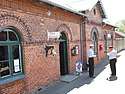 | Stationsvej 10, 4941 Bandholm | 54°50′8.65″N 11°28′55.5″E / 54.8357361°N 11.482083°E | Station building from 1869-70[14] |
| Birketvej 64-66 | Birketvej 64, 4941 Bandholm | 54°50′9.8″N 11°28′30.48″E / 54.836056°N 11.4751333°E | 16 bays long and six bays wide half-timbered building from the middle of the 18th century and the hedging along Birketvej and Smedestræde[15] | |
| Hvedemagasinet, Bandholm | Havnegade 23, 4941 Bandholm | 54°50′6.19″N 11°29′2.39″E / 54.8350528°N 11.4839972°E | Two-storey storage building from the middle of the 19th century[16] | |
4943 Torrig L
| Listing name | Image | Location | Coordinates | Sescription |
|---|---|---|---|---|
| Pederstrup |  | Pederstrupvej 124, 4943 Torrig L | 54°53′45.34″N 11°15′55.85″E / 54.8959278°N 11.2655139°E | Neoclassical manor house from 1813-22 by Christian Frederik Hansen[17] |
4944 Fejø
| Listing name | Image | Location | Coordinates | Sescription |
|---|---|---|---|---|
| Herredsvej 281 | Herredsvej 281, 4944 Fejø | 54°57′5.53″N 11°25′59.98″E / 54.9515361°N 11.4333278°E | Half-timbered building from c. 1780[18] | |
4960 Holeby
| Listing name | Image | Location | Coordinates | Sescription |
|---|---|---|---|---|
| Kjærstrup | Kærstrupvej 17, 4960 Holeby | 54°41′33.2″N 11°31′36.49″E / 54.692556°N 11.5268028°E | Main building from 1765 /older cellar) which was adapted in 1836 and tower from 1868[19] | |
4970 Rødby
| Listing name | Image | Location | Coordinates | Sescription |
|---|---|---|---|---|
| Højbygårds Skovløberhus | Højbygårdvej 22, 4970 Rødby | 54°41′28.07″N 11°27′3.7″E / 54.6911306°N 11.451028°E | Residential building from c. 1850[20] | |
| Højbygårds Skovløberhus | Højbygårdvej 22, 4970 Rødby | 54°41′28.07″N 11°27′3.7″E / 54.6911306°N 11.451028°E | Residential building from c. 1850[21] | |
| Købelev Rectory | Rødbyvej 22, 4970 Rødby | 54°40′17.14″N 11°27′35.47″E / 54.6714278°N 11.4598528°E | Main building from 1856 by L.A. Winstrup with later alterations from 1906 by H.C. Glahn, the two side wings from the 16th or early 17th century, moats and bridges[22] | |
| Willer House |  | Vestergade 1, 4970 Rødby | 54°41′43.6″N 11°23′14.9″E / 54.695444°N 11.387472°E | House from 1729[23] |
References
- ↑ https://www.kulturarv.dk/fbb/sagvis.pub?sag=9716300
- ↑ https://www.kulturarv.dk/fbb/sagvis.pub?sag=9716300
- ↑ https://www.kulturarv.dk/fbb/sagvis.pub?sag=10297050
- ↑ https://www.kulturarv.dk/fbb/sagvis.pub?sag=10252930
- ↑ https://www.kulturarv.dk/fbb/sagvis.pub?sag=9716292
- ↑ https://www.kulturarv.dk/fbb/sagvis.pub?sag=9560677
- ↑ https://www.kulturarv.dk/fbb/sagvis.pub?sag=9560681
- ↑ https://www.kulturarv.dk/fbb/sagvis.pub?sag=10340370
- ↑ https://www.kulturarv.dk/fbb/sagvis.pub?sag=9560671
- ↑ https://www.kulturarv.dk/fbb/sagvis.pub?sag=9560683
- ↑ https://www.kulturarv.dk/fbb/sagvis.pub?sag=9560658
- ↑ https://www.kulturarv.dk/fbb/sagvis.pub?sag=9560651
- ↑ https://www.kulturarv.dk/fbb/sagvis.pub?sag=10252924
- ↑ https://www.kulturarv.dk/fbb/sagvis.pub?sag=9560668
- ↑ https://www.kulturarv.dk/fbb/sagvis.pub?sag=9560655
- ↑ https://www.kulturarv.dk/fbb/sagvis.pub?sag=9560665
- ↑ https://www.kulturarv.dk/fbb/sagvis.pub?sag=9468635
- ↑ https://www.kulturarv.dk/fbb/sagvis.pub?sag=10252927
- ↑ https://www.kulturarv.dk/fbb/sagvis.pub?sag=9405991
- ↑ https://www.kulturarv.dk/fbb/sagvis.pub?sag=10340378
- ↑ https://www.kulturarv.dk/fbb/sagvis.pub?sag=10340378
- ↑ https://www.kulturarv.dk/fbb/sagvis.pub?sag=9405984
- ↑ https://www.kulturarv.dk/fbb/sagvis.pub?sag=10340355
External links
| Wikimedia Commons has media related to Listed buildings in Lolland Kommune. |
This article is issued from
Wikipedia.
The text is licensed under Creative Commons - Attribution - Sharealike.
Additional terms may apply for the media files.