Listed buildings in Gribskov Municipality
This list of listed buildings in Gribskov Municipality lists listed buildings in
List
3120 Dronningmølle
| Listing name | Image | Location | Coordinates | Description |
|---|---|---|---|---|
| Munkeruphus | 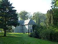 | Munkerup Strandvej 78, 3120 Dronningmølle | 56°6′34.21″N 12°21′55.75″E / 56.1095028°N 12.3654861°E | Country house from 1916 by Therkel H. Hjejle og Niels Rosenkjær[1] |
| Munkerup Strandvej 78, 3120 Dronningmølle | 56°6′34.21″N 12°21′55.75″E / 56.1095028°N 12.3654861°E | Outbuilding from 1917[2] | ||
| Rudolph Tegner Museum | 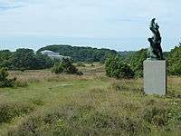 | Museumsvej 19, 3120 Dronningmølle | 56°5′11.15″N 12°24′2.06″E / 56.0864306°N 12.4005722°E | Museum building from1938 by Rudolph Tegner and Ernst Ishøy in association with Mogens Lassen [3] |
3200 Helsinge
| Listing name | Image | Location | Coordinates | Description |
|---|---|---|---|---|
| Kongensgave |  | Østergade 55, 3200 Helsinge | 56°1′27.48″N 12°12′26.88″E / 56.0243000°N 12.2074667°E | [4] |
| Pibe Windmill |  | Høbjergvej 34, 3200 Helsinge | 56°7′9.02″N 12°13′23.17″E / 56.1191722°N 12.2231028°E | Stub mill from 1789[5] |
3210 Vejby
| Listing name | Image | Location | Coordinates | Description |
|---|---|---|---|---|
| Rågegården | Rågeleje Strandvej 1A, 3210 Vejby | 56°6′21.91″N 12°10′42.64″E / 56.1060861°N 12.1785111°E | House from 1915 by Povl Baumann[6] | |
| Rågeleje Strandvej 1A, 3210 Vejby | 56°6′21.91″N 12°10′42.64″E / 56.1060861°N 12.1785111°E | Stables from 1915 by Povl Baumann[7] | ||
3220 Tisvildeleje
| Listing name | Image | Location | Coordinates | Description |
|---|---|---|---|---|
| Rigmor Stampes Vej 15 | Rigmor Stampes Vej 15, 3220 Tisvildeleje | 56°2′53.3″N 12°5′50.18″E / 56.048139°N 12.0972722°E | Guesthouse at Niels Bohr's holiday home from 1957 by Vilhelm Wohlert[8] | |
| Sandflugtsmonumentet |  | Alleen 0, 3220 Tisvildeleje | 56°3′9.41″N 12°5′57.85″E / 56.0526139°N 12.0994028°E | Monument from 1738 by Elias David Häusser and Didrick Gercken[9] |
| Silkebjerg 3 | Silkebjerg 3, 3220 Tisvildeleje | 56°2′5.11″N 12°5′55.66″E / 56.0347528°N 12.0987944°E | Thatched, wooden leisure home in Tibirke Bakker from 1932 and the studio wing from 1937[10] | |
| Strandvejen 20 | Strandvejen 20, 3220 Tisvildeleje | 56°3′51.22″N 12°4′52.38″E / 56.0642278°N 12.0812167°E | Holiday home from1956 by Arne Jakobsen[11] | |
| Villa Vendle | Ved Gærdet 1, 3220 Tisvildeleje | 1953 | Country House from 1912 by 1912 af Bent Helweg-Møller[12] | |
| Ved Gærdet 1, 3220 Tisvildeleje | 1953 | Country House from 1912 by 1912 af Bent Helweg-Møller[13] | ||
3230 Græsted
| Listing name | Image | Location | Coordinates | Description |
|---|---|---|---|---|
| Esrum Abbey |  | Klostergade 11A, 3230 Græsted | 56°2′50.8″N 12°22′38.4″E / 56.047444°N 12.377333°E | [14] |
| Esrum Watermill |  | Klostergade 12A, 3230 Græsted | 56°2′46.67″N 12°22′37.12″E / 56.0462972°N 12.3769778°E | Main building from c. 1880[15] |
 | Klostergade 12A, 3230 Græsted | 56°2′46.67″N 12°22′37.12″E / 56.0462972°N 12.3769778°E | Northern stables wing[16] | |
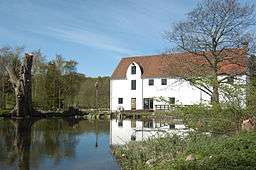 | Klostergade 12B, 3230 Græsted | 56°2′45.57″N 12°22′36.71″E / 56.0459917°N 12.3768639°E | Residential extension to the watermill building[17] | |
 | Klostergade 12C, 3230 Græsted | 56°2′46.94″N 12°22′38.14″E / 56.0463722°N 12.3772611°E | Watermill and ålekiste[18] | |
 | Klostergade 12D, 3230 Græsted | 56°2′46.15″N 12°22′37.67″E / 56.0461528°N 12.3771306°E | Southern stables wing[19] | |
3250 Gilleleje
| Listing name | Image | Location | Coordinates | Description |
|---|---|---|---|---|
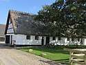
| Fiskerhuset | 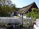 | Østergade 10, 3250 Gilleleje | 56°7′25.36″N 12°18′35.36″E / 56.1237111°N 12.3098222°E | Fisherman's House from the late 18th century which was adapted in 1868[20] |
| Østergade 10, 3250 Gilleleje | 56°7′25.36″N 12°18′35.36″E / 56.1237111°N 12.3098222°E | Outwing[21] | ||
| Nakkehoved Lighthouse | 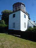 | Fyrvejen 27, 3250 Gilleleje | 56°7′8.75″N 12°20′58.63″E / 56.1190972°N 12.3496194°E | Lighthouse from 1772 by G. D. Anthon with later alterations[22] |
 | Fyrvejen 29A, 3250 Gilleleje | 56°7′8.45″N 12°20′57.11″E / 56.1190139°N 12.3491972°E | Attached residence from1772 by G. D. Anthon with later alterations[23] | |
| Nakkehoved Western Lighthouse | 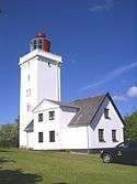 | Fyrvejen 25A, 3250 Gilleleje | 56°7′9.02″N 12°20′34.88″E / 56.1191722°N 12.3430222°E | Lighthouse from 1772 by Georg David Anthon which was altered and heightened in 1898[24] |
| Fyrvejen 25A, 3250 Gilleleje | 56°7′9.02″N 12°20′34.88″E / 56.1191722°N 12.3430222°E | Attached residence from 1772 by Georg David Anthon with later alterations[25] | |
See also
References
- ↑ https://www.kulturarv.dk/fbb/sagvis.pub?sag=5693615
- ↑ https://www.kulturarv.dk/fbb/sagvis.pub?sag=5693615
- ↑ https://www.kulturarv.dk/fbb/sagvis.pub?sag=5693632
- ↑ https://www.kulturarv.dk/fbb/sagvis.pub?sag=5840727
- ↑ https://www.kulturarv.dk/fbb/sagvis.pub?sag=5840733
- ↑ https://www.kulturarv.dk/fbb/sagvis.pub?sag=5693629
- ↑ https://www.kulturarv.dk/fbb/sagvis.pub?sag=5693629
- ↑ https://www.kulturarv.dk/fbb/sagvis.pub?sag=5840735
- ↑ https://www.kulturarv.dk/fbb/sagvis.pub?sag=5840724
- ↑ https://www.kulturarv.dk/fbb/sagvis.pub?sag=5840737
- ↑ https://www.kulturarv.dk/fbb/sagvis.pub?sag=5840730
- ↑ https://www.kulturarv.dk/fbb/sagvis.pub?sag=120297195
- ↑ https://www.kulturarv.dk/fbb/sagvis.pub?sag=120297195
- ↑ https://www.kulturarv.dk/fbb/sagvis.pub?sag=5693623
- ↑ https://www.kulturarv.dk/fbb/sagvis.pub?sag=5693627
- ↑ https://www.kulturarv.dk/fbb/sagvis.pub?sag=5693627
- ↑ https://www.kulturarv.dk/fbb/sagvis.pub?sag=5693627270-5797-2
- ↑ https://www.kulturarv.dk/fbb/sagvis.pub?sag=5693627
- ↑ [https://www.kulturarv.dk/fbb/sagvis.pub?sag=5693627
- ↑ https://www.kulturarv.dk/fbb/sagvis.pub?sag=5693620
- ↑ https://www.kulturarv.dk/fbb/sagvis.pub?sag=5693620
- ↑ https://www.kulturarv.dk/fbb/sagvis.pub?sag=5693635
- ↑ https://www.kulturarv.dk/fbb/sagvis.pub?sag=5693635
- ↑ https://www.kulturarv.dk/fbb/sagvis.pub?sag=5693635
- ↑ https://www.kulturarv.dk/fbb/sagvis.pub?sag=5693635
External links
| Wikimedia Commons has media related to Listed buildings in Gribskov Kommune. |
This article is issued from
Wikipedia.
The text is licensed under Creative Commons - Attribution - Sharealike.
Additional terms may apply for the media files.