| Listing name |
Image |
Location |
Coordinates |
Contributing resource |
Ref |
|---|
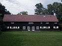
| Brede 33-77 |  | Brede 33, 2800 Kongens Lyngby | 55°47′39.18″N 12°29′53.6″E / 55.7942167°N 12.498222°E / 55.7942167; 12.498222 | Former industrial complex | Ref |
 | Brede 52, 2800 Kongens Lyngby | 55°47′37.15″N 12°29′53.73″E / 55.7936528°N 12.4982583°E / 55.7936528; 12.4982583 | Former industrial complex | Ref |
| Brede 60, 2800 Kongens Lyngby | 55°47′35.81″N 12°29′53.85″E / 55.7932806°N 12.4982917°E / 55.7932806; 12.4982917 | Former industrial complex | Ref |
| Brede 62, 2800 Kongens Lyngby | 55°47′34.68″N 12°29′53.48″E / 55.7929667°N 12.4981889°E / 55.7929667; 12.4981889 | Former industrial complex | Ref |
| Brede 64, 2800 Kongens Lyngby | 55°47′33.77″N 12°29′53.8″E / 55.7927139°N 12.498278°E / 55.7927139; 12.498278 | Former industrial complex | Ref |
 | Brede 70, 2800 Kongens Lyngby | 55°47′37.79″N 12°29′54.59″E / 55.7938306°N 12.4984972°E / 55.7938306; 12.4984972 | Former industrial complex | Ref |
 | Brede 75, 2800 Kongens Lyngby | 55°47′37.82″N 12°29′56.34″E / 55.7938389°N 12.4989833°E / 55.7938389; 12.4989833 | Former industrial complex | Ref |
| Brede Allé 66-67 og 69 |  | Brede 66, 2800 Kongens Lyngby | 55°47′26.15″N 12°29′57.46″E / 55.7905972°N 12.4992944°E / 55.7905972; 12.4992944 | House from 1895 | Ref |
 | Brede 69, 2800 Kongens Lyngby | 55°47′24.31″N 12°29′56.72″E / 55.7900861°N 12.4990889°E / 55.7900861; 12.4990889 | House from 1894, adapted for use as a school by Niels Peter Ulstrup Hansen in 1920 | Ref |
| Brede Børnehave | 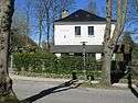 | Brede 81, 2800 Kongens Lyngby | 55°47′39.95″N 12°29′51″E / 55.7944306°N 12.49750°E / 55.7944306; 12.49750 | Day care from 1905 designed by Vilhelm Suhr | Ref |
| Brede Textile Manufactury | 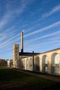 | Brede Hovedbygning 1, 2800 Kongens Lyngby | | 18th century industrial complex | Ref |
| Brede Water Tower | | Mølleåparken 40, 2800 Kongens Lyngby | 55°47′38.87″N 12°30′6.05″E / 55.7941306°N 12.5016806°E / 55.7941306; 12.5016806 | Water tower from 1907 | Ref |
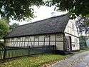
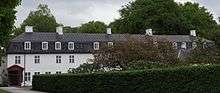
| Bøgely | | Raadvad 2 and 2, 2800 Kongens Lyngby | 1843 | The south and west wings of a three-winged house from 1843 | Ref |
| Raadvad 2 and 2A, 2800 Kongens Lyngby | 1843 | The south north wing of a three-winged house from 1843 | Ref |
| Raadvad 2 and 2A, 2800 Kongens Lyngby | 1843 | Detached building located to the east of the three-winged complex | Ref |
| Christianelyst |  | Nybrovej 393, 2800 Kongens Lyngby | c. 1800 | Three-winged house from c. 1800 | Ref |
 | Nybrovej 393, 2800 Kongens Lyngby | c. 1800 | Three-winged house from c. 1800 | Ref |
 | Nybrovej 393, 2800 Kongens Lyngby | c. 1800 | Three-winged house from c. 1800 | Ref |
| Eremitagen |  | Dyrehaven 4, 2800 Kongens Lyngby | 1734 | Royal hunting lodge designed by Lauritz de Thurah | Ref |
| Frieboeshvile |  | Country house from 1755 | . 1755 | | Ref |
| Fuglevad Watermill |  | Møllevej 4, 2800 Kongens Lyngby | 1888 | Two-winged watermill from 187 | Ref |
| Fuglevad Windmill | 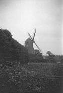 | Kongevejen 102, 2800 Kongens Lyngby | 1814 | Windmill from 1814 | Ref |
| Gramlille | 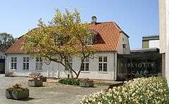 | Lyngby Hovedgade 28, 2800 Kongens Lyngby | 1800 34 | House from c. 1800 | Ref |
| Louisekilde | .jpg) | Nybrovej 423, 2800 Kongens Lyngby | 1850 | Memorial from 1791 to Christiana Louise Warnstedt in Spurveskjul Forest | Ref |
| Lyngby Nordre Mølle | 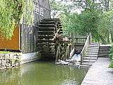 | Lyngby Hovedgade 24A, 2800 Kongens Lyngby | 1850 | Watermill and attached storage building from c. 1850 | Ref |
| Lyngby Rectory | 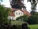 | Lyngby Kirkestræde 12, 2800 Kongens Lyngby | 1843 | House from 1846 with extension from 1914 | Ref |
 | Lyngby Kirkestræde 12, 2800 Kongens Lyngby | 1843 | Stable and gate wing | Ref |
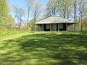
| Lystoftegård | | Lystoftevej 17, 2800 Kongens Lyngby | 1808 | Two storey main building with Mansard roof dating from 1816, but altered by Hans Henrik Engqvist in 1947 | Ref |
| Lystoftevej 80 |  | Lystoftevej 80, 2800 Kongens Lyngby | 1808 | Former workers' housing from 1913 | Ref |
| Marienborg | 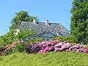 | Nybrovej 410, 2800 Kongens Lyngby | 1808 | Country house from the second half of the 18th century | Ref |
| Møllevej 5 | .jpg) | Møllevej 5, 2800 Kongens Lyngby | 1843 | House from 1873 | Ref |
| Møllevej 5, 2800 Kongens Lyngby | 1843 | Outhouse | Ref |
| Møllevej 10A-B | .jpg) | Møllevej 10A, 2800 Kongens Lyngby | 1808 | Former nursery home from children from 1863 | Ref |
| Moyel House | 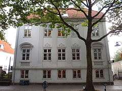 | Lyngby Hovedgade 37, 2800 Kongens Lyngby | 18+6 | Tree-winged house from 1806 | Ref |
 | Lyngby Hovedgade 37, 2800 Kongens Lyngby | 18+6 | Detached building from 1806 | Ref |
| Raadvad Hostel | | Raadvad 1, 2800 Kongens Lyngby | 1808 | Former school building from 1918-19 by Harald Lønborg-Jensen | Ref |
| Sophienholm | .jpg) | Nybrovej 401, 2800 Kongens Lyngby | 1808 | Neoclassical country house from 1808 designed by Joseph-Jacques Ramée | Ref |
| Sorgenfri Palace |  | Kongevejen 2, 2800 Kongens Lyngby | 1843 | Main building originally from 1756 by Lauritz de Thurah on foundation and cellars from 1705-06 by François Dieussart but later adapted in 1791-94 by Peter Meyn | Ref |
| Kongevejen 2, 2800 Kongens Lyngby | 1843 | Kavalerbygningen: Building originally from 1743-44 by Lauritz de Thurah but adapted in 1790 by Peter Meyn | Ref |
| Kongevejen 2, 2800 Kongens Lyngby | 1843 | The south north wing of a three-winged house from 1843 | Ref |
 | Kongevejen 2, 2800 Kongens Lyngby | | The Norwegian House: Pavilion from 1809 by Nicolai Abildgaard | Ref |
 | Kongevejen 2A, 2800 Kongens Lyngby | 1843 | Damebygningen: Building by Lauritz de Thurah | Ref |
| Kongevejen 4A, 2800 Kongens Lyngby | 1843 | "The Long Wing": Former gardener's house from 1840-48 by Jørgen Hansen Koch | Ref |
| Kongevejen 6, 2800 Kongens Lyngby | 1843 | The Swiss House: Half-timbered building from c. 1800 by Nicolai Abildgaard | Ref |
| Schallsvej 6, 2800 Kongens Lyngby | 1843 | Schallske musikhus at Mølleåen from c. 1800 | Ref |
| Støvlet Kathrine's House |  | Gammel Lundtoftevej 31, 2800 Kongens Lyngby | 1843 | House from 1808 | Ref |
| Tårbæk Strandvej 82 |  | Taarbæk Strandvej 82, 2930 Klampenborg | 1808 | Two-storey wooden building by Michael Gottlieb Bindesbøll | Ref |
| Ørholm | 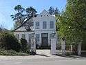 | Ørholmvej 61, 2800 Kongens Lyngby | 55°47′59.27″N 12°30′17.75″E / 55.7997972°N 12.5049306°E / 55.7997972; 12.5049306 | Main building from the 18th century | Ref |
|
.jpg)