List of road routes in the Northern Territory
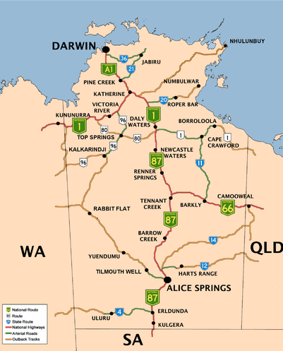
Road routes in the Northern Territory assist drivers navigating roads throughout the territory, by identifying important through-routes. The Northern Territory's National Highways are the main routes connecting Darwin to the adjacent states of Queensland, South Australia, and Western Australia. National Routes spur off the National Highways, and are other routes of national importance, while the remaining significant routes are designated as State Routes.[1][2]
According to the New South Wales Roads and Maritime Services, the Northern Territory has begun converting their numbered routes to alphanumeric routes, with a "progressive replacement" scheme that sees alphanumeric route markers introduced only when signs are replaced.[3]
National Highways and Routes
There are three national highways and three national routes in the Northern Territory.[1][2]
- This transport-related list is incomplete; you can help by expanding it.
| Route | Planned alphanumeric route[4] | Component roads | From | Via | To | Length | Notes |
|---|---|---|---|---|---|---|---|
National Highway 1 |
A1 |
WA–NT border (near Keep River National Park) | Katherine | Daly Waters | Continues east from Daly Waters as National Route 1 | ||
| Katherine | Adelaide River | Darwin | Partially signed as alphanumeric route A1; spur section connecting to Darwin | ||||
National Highway 66 |
B66 |
Tennant Creek | Qld–NT border (near Ranken) | ||||
National Highway 87 |
A87 |
Daly Waters | Alice Springs | SA–NT border (near Kulgera) | |||
National Route 1 |
B1 |
Daly Waters | Borroloola | Qld–NT border (near Wollogorang Airport) | Continues north from Daly Waters as National Highway 1 | ||
National Route 80 |
C80 |
Victoria Highway (29.4 km (18 mi) south-east of Timber Creek | Top Springs | Birdum | 393 km (244 mi) | ||
National Route 96 |
B96 |
Willeroo, NT | Top Springs | Duncan Road, Nicholson, WA | 581 km (361 mi) |
State Routes
State routes are numbered based on their position in the territory, generally increasing in number from south to north.[1]
- This transport-related list is incomplete; you can help by expanding it.
| Route | Component roads | Planned Alphanumeric Replacement[5] | From | Via | To | Length | Notes |
|---|---|---|---|---|---|---|---|
State Route 2 |
|
Larapinta Drive, Hugh | West MacDonnell National Park | Larapinta Drive, Namatjira | |||
State Route 3 |
|
Lasseter Highway | Petermann | Watarrka National Park | |||
State Route 4 |
Erldunda | Uluru | |||||
|
Uluru | WA–NT border (near Kaltukatjara) | |||||
State Route 5 |
Burt Plain | Yuendumu | WA–NT border (near Tanami) | ||||
State Route 6 |
Watarrka National Park | Hermannsburg | Alice Springs | ||||
State Route 8 |
|
Ross | Ross River | Arltunga Historical Reserve | |||
State Route 11 |
Tablelands | Creswell | Cape Crawford | ||||
State Route 12 |
Burt Plain | Atitjere | Qld–NT border (near Tobermorey) | 496 km (308 mi) | |||
State Route 14 |
Plenty Highway, Anmatjere | Ampilatwatja | Qld–NT border (near Lake Nash) | ||||
State Route 16 |
|
Lake Woods | Creswell | Calvert | |||
State Route 20 |
Mataranka | Roper Bar | |||||
State Route 21 |
Pine Creek | Kakadu National Park | Jabiru | ||||
State Route 23 |
|||||||
State Route 24 |
|
Venn | Barunga | Bulman | |||
State Route 28 |
|
Robin Falls | Daly River | Wadeye | 256 km (159 mi) | ||
State Route 30 |
|
Coomalie Creek | Rakula | Blackmore | 145 km (90 mi) | ||
State Route 34 |
Noonamah | Cox Peninsula | Partially signed as alphanumeric route B34 | ||||
State Route 36 |
McMinns Lagoon | Jabiru | Kakadu National Park | 227 km (141 mi) |
See also
References
- 1 2 3 "250k Topographic Map" (Map). NT Atlas and Spatial Data Directory. Northern Territory Government. 2004. Retrieved 16 May 2014.
- 1 2 Department of Transport (April 1998). "Map of all NT Roads" (PDF). Northern Territory Government. Archived from the original (PDF) on 5 May 2013. Retrieved 13 January 2014.
- ↑ Roads and Maritime Services. "Questions and answers: A better way to navigate NSW roads" (PDF). New South Wales Government. Archived (PDF) from the original on 16 May 2014. Retrieved 16 May 2014.
- ↑
- ↑