Buntine Highway
| Buntine Highway Western Australia–Northern Territory | |
|---|---|
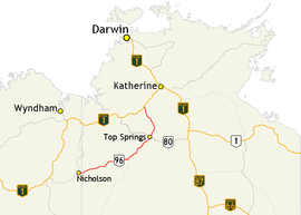 | |
| Map of north-western Australia with Buntine Highway highlighted in red | |
| General information | |
| Type | Rural road |
| Length | 581 km (361 mi) |
| Route number(s) |
|
| Former route number |
|
| Major junctions | |
| West end | Duncan Road, Nicholson, Western Australia |
|
| |
| East end |
|
| Location(s) | |
| Major settlements | Kalkaringi, Wave Hill, Top Springs |
The Buntine Highway is a 581-kilometre highway in the Northern Territory and Western Australia. It runs from the Victoria Highway via Top Springs and Kalkarindji and then to Nicholson, Western Australia.[1] The section from the Victoria Highway to Kalkaringi is a single-lane sealed road with a few dual-lane sections; the remaining section is unsealed.[2] Funding for maintenance is provided by the Northern Territory government.[3]
Major intersections
The only major intersection on this road is with the Buchanan Highway (National Route 80) at Top Springs.
See also
![]()
References
- ↑ Department of Transport (April 1998). "Map of all NT Roads" (PDF). Northern Territory Government. Archived from the original (PDF) on 5 May 2013. Retrieved 13 January 2014.
- ↑ Hema, Maps (2007). Australia Road and 4WD Atlas (Map). Eight Mile Plains Queensland: Hema Maps. p. 98. ISBN 978-1-86500-456-3.
- ↑ "Funding for NT roads". 24 April 2010. Archived from the original on 6 March 2014. Retrieved 6 March 2014.
Road infrastructure in Northern Territory | ||
|---|---|---|
| National highways | ||
| Highways | ||
| Major urban roads | ||
| Outback tracks and numbered state routes | ||
Road infrastructure in Western Australia | ||
|---|---|---|
| Freeways | ||
| Metropolitan highways | ||
| Highways and major roads |
| |
| Outback tracks | ||
| Lists |
| |
This article is issued from
Wikipedia.
The text is licensed under Creative Commons - Attribution - Sharealike.
Additional terms may apply for the media files.