Buchanan Highway
| Buchanan Highway Northern Territory | |
|---|---|
 | |
| Map of north-western Australia with Buchanan Highway highlighted in red | |
| General information | |
| Type | Track |
| Length | 393 km (244 mi) |
| Route number(s) |
|
| Major junctions | |
| West end |
|
|
| |
| East end |
|
| Location(s) | |
| via | Gregory National Park, Victoria River Downs, Top Springs |
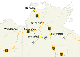
The Buchanan Highway, Northern Territory, Australia runs west from Birdum on the Stuart Highway crossing the Buntine Highway at Top Springs and eventually connecting with the Victoria Highway near Timber Creek.[1] It is unsealed for its entire length, at 393 kilometres.[2] Funding for maintenance is provided by the Northern Territory government.[3]
Major intersections
The only major intersection on this road is with the Buntine Highway (National Route 96) at Top Springs.
See also
![]()
References
- ↑ Department of Transport (April 1998). "Map of all NT Roads" (PDF). Northern Territory Government. Archived from the original (PDF) on 5 May 2013. Retrieved 13 January 2014.
- ↑ Hema, Maps (2007). Australia Road and 4WD Atlas (Map). Eight Mile Plains Queensland: Hema Maps. pp. 96–98. ISBN 978-1-86500-456-3.
- ↑ "Funding for NT roads". 24 April 2010. Archived from the original on 6 March 2014. Retrieved 6 March 2014.
- The Readers Digest Great World Atlas, 1975
- Times Atlas of the World, Concise Edition, (Australia and New Zealand Edition), 8th Edition 2002. ISBN 0-00-766185-1
Road infrastructure in Northern Territory | ||
|---|---|---|
| National highways | ||
| Highways | ||
| Major urban roads | ||
| Outback tracks and numbered state routes | ||
This article is issued from
Wikipedia.
The text is licensed under Creative Commons - Attribution - Sharealike.
Additional terms may apply for the media files.