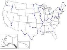
List of river borders of U.S. states
Because of its unique history, many of the boundaries of the political divisions of the United States were artificially constructed (rather than being permitted to evolve and drawn using natural features of the landscape). Therefore, many U.S. states have straight lines as boundaries, especially in the West. However, there are a number of states, particularly in the Midwest, North and South with at least partial river borders.
The rule of the thread of the channel and its exceptions
Typically the boundary is the "thread of the channel", under a rule that the United States inherited from England, where it applies to boundaries between counties. There are at least four exceptions, where the boundary is one bank of the river rather than the thread of the channel:
- The boundary between New Hampshire and Vermont is the west bank of the Connecticut River. This was established as the eastern boundary of New York by a grant of King Charles II in 1664. It was disregarded by Governor Benning Wentworth of New Hampshire, who treated the New Hampshire Grants west of the river as a de facto part of New Hampshire during the years 1649–1764, but King George III put an end to that in 1764. In August 1781 the Continental Congress decided it would recognize the then largely unrecognized state of Vermont, which had been organized in defiance of New York, on condition that Vermont would agree to certain boundaries. In 1782, the legislature of Vermont agreed, but nonetheless Vermont was not admitted to the Union until 1791. In 1933, citing the 1782 legislation, the United States Supreme Court denied the petition from the state of Vermont to make the boundary the thread of the channel.
- The boundary between Kentucky and the three states to its north – Ohio, Indiana, and Illinois – is the north bank of the Ohio river. In 1763, Britain defeated France in the Seven Years' War, whose North American theater was called the French and Indian War. At that time Canada, which had been a French colony, became a British colony, and Parliament made the north bank of the Ohio the southern boundary of Canada. The river was thus included in the district of Kentucky, which was then a part of Virginia until it became a separate state in 1792.
- The boundary between Delaware and New Jersey north of 39° 30' north latitude is the east bank of the Delaware River.
- The boundary between Delaware and New Jersey, south of a certain point, is the west bank of the Delaware River rather than the thread of the channel.
- The boundary between Maryland and Virginia is the south bank of the Potomac River. This also applies both to the border between Maryland and West Virginia (from Harper's Ferry to the source of the Potomac near the Fairfax Stone) since the latter was at one point part of Virginia, and to the border between Virginia and Washington, D.C. since the capital was established from a section of Maryland property.
List of river borders
- Arthur Kill: New Jersey, New York (tidal strait)
- Big Sandy River: Kentucky, West Virginia
- Big Sioux River: South Dakota, Iowa
- Blackwater River: Virginia, North Carolina
- Bois de Sioux River: South Dakota, Minnesota, North Dakota
- Brule River: Michigan, Wisconsin
- Byram River: Connecticut, New York
- Catawba River: North Carolina, South Carolina
- Chattahoochee River: Alabama, Georgia
- Chattooga River: Georgia, South Carolina
- Colorado River: Arizona, Nevada, California, Baja California
- Columbia River: Washington, Oregon
- Connecticut River: New Hampshire, Vermont
- Delaware River: New York, Pennsylvania, New Jersey, Delaware
- Des Moines River: Iowa, Missouri
- Detroit River: Michigan, Ontario
- Great Miami River (mouth only): Ohio, Indiana
- Halls Stream: New Hampshire, Quebec
- Hudson River (lower part only): New Jersey, New York
- Kill Van Kull: New Jersey, New York (tidal strait)
- Menominee River: Michigan, Wisconsin
- Mississippi River: Minnesota, Wisconsin, Iowa, Illinois, Missouri, Kentucky, Tennessee, Arkansas, Mississippi, and Louisiana
- Missouri River: South Dakota, Nebraska, Iowa, Missouri, Kansas
- Montreal River: Michigan (Upper Peninsula), Wisconsin
- Niagara River: New York, Ontario
- Ohio River: Illinois, Indiana, Ohio, Kentucky, West Virginia
- Palmer River: Rhode Island, Massachusetts
- Pawcatuck River: Connecticut, Rhode Island
- Pearl River: Mississippi, Louisiana
- Perdido River: Florida, Alabama
- Pigeon River: Minnesota, Ontario
- Pine River: Minnesota, Ontario
- Piscataqua River: Maine, New Hampshire
- Pocomoke River: Maryland, Virginia
- Poteau River: Arkansas, Oklahoma
- Potomac River: Maryland, Virginia, D.C., West Virginia
- Poultney River: Vermont, New York
- Rainy River: Minnesota, Ontario
- Red River of the North: North Dakota, Minnesota
- Red River of the South: Texas, Oklahoma, Arkansas
- Rio Grande: New Mexico, Texas, Chihuahua, Coahuila, Nuevo León, Tamaulipas
- Runnins River: Rhode Island, Massachusetts
- Sabine River: Texas, Louisiana
- St. Clair River: Michigan, Ontario
- St. Croix River (Maine-New Brunswick): Maine, New Brunswick
- St. Croix River (Wisconsin-Minnesota): Minnesota, Wisconsin
- St. Francis River (Missouri-Arkansas): Arkansas, Missouri
- St. Francis River (Quebec-Maine): Maine, Quebec
- St. John River: Maine, New Brunswick
- St. Lawrence River: New York, Ontario
- St. Louis River: Minnesota, Wisconsin
- St. Marys River (Florida-Georgia): Florida, Georgia
- St. Marys River (Michigan-Ontario): Michigan, Ontario
- Salmon Falls River: New Hampshire, Maine
- Savannah River: South Carolina, Georgia
- Snake River: Idaho, Washington, Oregon
- Tennessee River: Kentucky, Tennessee, Mississippi, Alabama
- Tug Fork River: Kentucky, West Virginia, Virginia
- Tugaloo River: Georgia, South Carolina
- Wabash River: Illinois, Indiana
The course of the Charles River was used to indirectly define the border between Massachusetts and Rhode Island. The Merrimack River defines part of the border between Massachusetts and New Hampshire, which runs parallel to the river, three miles north of it (see Northern boundary of Massachusetts.)