Kings County, Prince Edward Island
| Kings County | |
|---|---|
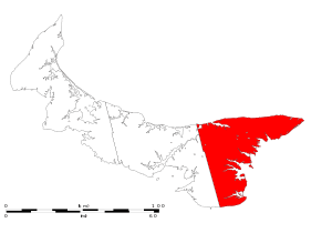 Location of Kings County in Prince Edward Island. | |
| Incorporated Towns & Municipalities | Georgetown (town), Montague (town), Souris (town) |
| Parishes | St. Patrick's Parish, East Parish, St. George's Parish, St. Andrew's Parish |
| Townships and royalties | |
| Area | |
| • Total | 1,684.35 km2 (650.33 sq mi) |
| Population (2011) | |
| • Total | 17,990 |
| • Density | 11/km2 (28/sq mi) |
| Average_Earnings | $36,407 |
Kings County (2011 population 17,990) is located in eastern Prince Edward Island, Canada.
It is the province's smallest, most rural and least-populated county. Kings County is also least dependent upon the agriculture industry compared with the other two counties, while being more heavily dependent on the fishery and forest industry. Comparatively large parts of the county are still forested and it hosts the province's largest sawmill. The only heavy industry, aside from forestry and industrial farming, is a small shipyard, although secondary manufacturing has been established in recent years.
The county was named by Capt. Samuel Holland in 1765 for King George III (1738-1820). As such, Kings County's shire town is Georgetown. The largest town is Montague.
In 2008, Kings County was the region with the second highest self-reported obesity rate in Canada.[1]
Communities
| Historical populations | ||
|---|---|---|
| Year | Pop. | ±% |
| 1991 | 19,328 | — |
| 1996 | 19,561 | +1.2% |
| 2001 | 19,180 | −1.9% |
| 2006 | 18,608 | −3.0% |
| 2011 | 17,990 | −3.3% |
| [2][3][4][5] | ||
- Towns
- Municipalities
- Unincorporated
- Indian reserves
- Morell 2
See also
References
- ↑ http://www.cihi.ca/CIHI-ext-portal/internet/en/document/factors+influencing+health/release_20june11_fig2
- ↑ "Census Profile - Kings, CTY, Prince Edward Island (Census division)". Canada 2011 Census. Statistics Canada. 2011. Retrieved 24 June 2014.
- ↑ "Census Profile - Kings County, Prince Edward Island (Health region)". Canada 2006 Census. Statistics Canada. 2006. Retrieved 24 June 2014.
- ↑ "Community profile - Kings County, Prince Edward Island (County)". Canada 2001 Census. Statistics Canada. 2001. Retrieved 24 June 2014.
- ↑ "Electronic Area Profiles - Kings County Prince Edward Island". Canada 1996 Census. Statistics Canada. 1996. Retrieved 24 June 2014.
External links
| Subdivisions | |
|---|---|
| Cities | |
| Towns | |
| Rural municipalities |
|
| Unincorporated communities | |
| Counties | |
| |