Prince County, Prince Edward Island
| Prince County Comté de Prince (French) | |
|---|---|
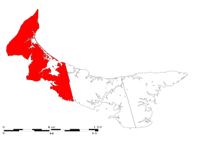 Location of Prince County in Prince Edward Island. | |
| Incorporated Towns & Municipalities | Summerside (city), Alberton (town), Borden-Carleton (town), Kensington (town), O'Leary (town) |
| Parishes | North Parish, Egmont Parish, Halifax Parish, Richmond Parish, St. David's Parish |
| Townships and royalties | |
| Area | |
| • Total | 1,979.87 km2 (764.43 sq mi) |
| Population (2011) | |
| • Total | 44,348 |
| • Density | 22/km2 (58/sq mi) |
| Average_Earnings | $38,916 |
Prince County is located in western Prince Edward Island, Canada. The county's defining geographic feature is Malpeque Bay, a sub-basin of the Gulf of St. Lawrence, which creates the narrowest portion of Prince Edward Island's landmass, an isthmus upon which the city of Summerside is located.
The geographic division created by Malpeque Bay is informally augmented by a socio-economic division between the more urban East Prince and rural West Prince, although the line of division generally varies. Much of Prince Edward Island's industrial base is concentrated in the eastern part of the county, with three large frozen French fry manufacturing plants, a potato chip manufacturing plant, and an aerospace industry located at a former air force base. Industrial farming for root crops such as potatoes accounts for the majority of rural economic activity, followed by fishing for shellfish such as lobster and crab.
The county was named by Capt. Samuel Holland in 1765 for George, Prince of Wales, who would later become King George IV (1762–1830). As such, Prince County's shire town was designated as Princetown, however the inferior harbour for Prince Royalty saw the settlement pattern change to give this honour to Summerside.
The name "Prince County" is notable for being unique for titling land subdivisions in the Commonwealth of Nations.
Transportation
Major Highways
Municipalities
| Historical populations | ||
|---|---|---|
| Year | Pop. | ±% |
| 1991 | 43,241 | — |
| 1996 | 44,566 | +3.1% |
| 2001 | 44,495 | −0.2% |
| 2006 | 44,499 | +0.0% |
| 2011 | 44,348 | −0.3% |
| [1][2][3][4] | ||
- Cities
- Towns
- Communities
- Indian reserves
References
- ↑ "Census Profile - Prince, CTY, Prince Edward Island (Census division)". Canada 2011 Census. Statistics Canada. 2011. Retrieved 24 June 2014.
- ↑ "Census Profile - Prince County, Prince Edward Island (Census Division)". Canada 2006 Census. Statistics Canada. 2006. Retrieved 24 June 2014.
- ↑ "Community profile - Prince County, Prince Edward Island (County)". Canada 2001 Census. Statistics Canada. 2001. Retrieved 24 June 2014.
- ↑ "Electronic Area Profiles - Prince County Prince Edward Island". Canada 1996 Census. Statistics Canada. 1996. Retrieved 24 June 2014.
Coordinates: 46°45′N 64°5′W / 46.750°N 64.083°W
| Subdivisions | |
|---|---|
| Cities | |
| Towns | |
| Rural municipalities |
|
| Unincorporated communities | |
| Counties | |
| |