| Name |
Address |
Coordinates |
IDF |
IDP |
IDM |
 |
Image |
|---|
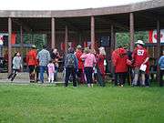
| Sahoyúé-§ehdacho National Historic Site |
Grizzly Bear Mountain and Scented Grass Hills, Great Bear Lake, Deline, NT |
65°39′04″N 121°42′07″W / 65.6512°N 121.702°W / 65.6512; -121.702 (Sahoyúé-§ehdacho National Historic Site) |
13033 |
|
|
Q15274363 |
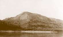
More images |
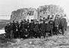
| Déline Fishery / Franklin's Fort |
, Deline, NT |
65°12′28″N 123°25′52″W / 65.2079°N 123.431°W / 65.2079; -123.431 (Déline Fishery / Franklin's Fort National Historic Site) |
14385 |
|
|
Q22974599 |
More images |
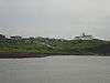
| Church of Our Lady of Good Hope |
, Fort Good Hope, NT |
66°15′08″N 128°38′42″W / 66.2521°N 128.645°W / 66.2521; -128.645 (Church of Our Lady of Good Hope) |
1207 |
|
|
Q3580199 |
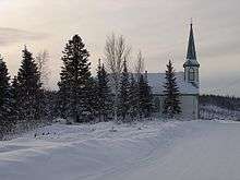
More images |
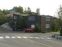
| Fort McPherson National Historic Site |
, Fort McPherson, NT |
67°26′20″N 134°52′52″W / 67.4389°N 134.881°W / 67.4389; -134.881 (Fort McPherson National Historic Site) |
1141 |
|
|
Q23940636 |
More images |
| Aviation Weather Station, Quarters / Storage Building 2 |
, Fort Reliance, NT |
62°42′45″N 109°09′58″W / 62.7126°N 109.166°W / 62.7126; -109.166 (Aviation Weather Station, Quarters / Storage Building 2) |
9907 |
|
|
|
 |
| Aviation Weather Station, Residence/ Radio Station Building |
, Fort Reliance, NT |
62°42′43″N 109°10′01″W / 62.712°N 109.167°W / 62.712; -109.167 (Aviation Weather Station, Residence/ Radio Station Building) |
9909 |
|
|
|
|
| Aviation Weather Station, Quarters / Storage Building 1 |
, Fort Reliance, NT |
62°43′18″N 109°08′24″W / 62.7216°N 109.14°W / 62.7216; -109.14 (Aviation Weather Station, Quarters / Storage Building 1) |
9919 |
|
|
|
|
| Aviation Weather Station, Quarters / Storage Building 3 |
, Fort Reliance, NT |
62°42′47″N 109°10′01″W / 62.7131°N 109.167°W / 62.7131; -109.167 (Aviation Weather Station, Quarters / Storage Building 3) |
11004 |
|
|
|
|
| Ice House |
, Fort Reliance, NT |
62°42′46″N 109°09′58″W / 62.7129°N 109.166°W / 62.7129; -109.166 (Ice House) |
11165 |
|
|
|
|
| Fort Reliance |
, Fort Reliance, NT |
62°28′15″N 108°33′43″W / 62.4708°N 108.562°W / 62.4708; -108.562 (Fort Reliance National Historic Site) |
15724 |
19348 |
|
Q5471902 |
|
| Fort Resolution |
, Fort Resolution, NT |
61°10′15″N 113°40′16″W / 61.1708°N 113.671°W / 61.1708; -113.671 (Fort Resolution National Historic Site) |
15669 |
|
|
Q23940685 |
|
| Ehdaa |
, Fort Simpson, NT |
61°51′22″N 121°20′24″W / 61.8561°N 121.34°W / 61.8561; -121.34 (Ehdaa) |
7758 |
|
|
Q22974408 |
More images |
| Faille Cabin |
, Fort Simpson, NT |
61°51′55″N 121°21′32″W / 61.8653°N 121.359°W / 61.8653; -121.359 (Faille Cabin) |
|
10198 |
|
|
|
| Old Barn |
, Fort Simpson, NT |
61°52′00″N 121°21′54″W / 61.8667°N 121.365°W / 61.8667; -121.365 (Old Barn) |
|
10329 |
|
|
|
| Hudson's Bay Company Shed |
, Fort Simpson, NT |
61°51′38″N 121°21′04″W / 61.8606°N 121.351°W / 61.8606; -121.351 (Hudson's Bay Company Shed) |
|
10434 |
|
|
|
| Lafferty House |
, Fort Simpson, NT |
61°52′08″N 121°22′12″W / 61.8689°N 121.37°W / 61.8689; -121.37 (Lafferty House) |
|
10435 |
|
|
|
| McPherson House |
, Fort Simpson, NT |
61°51′34″N 121°20′38″W / 61.8594°N 121.344°W / 61.8594; -121.344 (McPherson House) |
|
10436 |
|
|
|
| Fort Smith Mission |
Corner of Mercredi and Breynat Street, Fort Smith, NT |
60°00′14″N 111°52′48″W / 60.0039°N 111.88°W / 60.0039; -111.88 (Fort Smith Mission) |
|
1241 |
|
|
|
| Wardens Patrol Cabin |
Wood Buffalo National Park, Fort Smith, NT |
60°16′00″N 114°10′01″W / 60.2667°N 114.167°W / 60.2667; -114.167 (Wardens Patrol Cabin) |
4337 |
|
|
|
|
| Hay River Mission Sites |
, Hay River Reserve, NT |
60°48′55″N 115°47′49″W / 60.8153°N 115.797°W / 60.8153; -115.797 (Hay River Mission Sites) |
12080 |
|
|
Q22975451 |

More images |
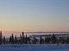
| Kittigazuit Archaeological Sites |
Mackenzie Delta, Inuvik, NT |
69°20′30″N 133°41′24″W / 69.3417°N 133.69°W / 69.3417; -133.69 (Kittigazuit Archaeological Sites) |
15001 |
|
|
Q22975203 |
|
| Parry's Rock Wintering Site |
Melville Island, Resolute, Nunavut, NT |
74°46′00″N 110°37′59″W / 74.7667°N 110.633°W / 74.7667; -110.633 (Parry's Rock Wintering Site) |
11660 |
|
|
Q3437594 |
More images |
| Nagwichoonjik |
, Tsiigehtchic, NT |
67°26′32″N 133°44′20″W / 67.4423°N 133.739°W / 67.4423; -133.739 (Nagwichoonjik) |
9161 |
|
|
Q22974983 |
More images |
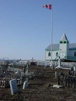
| Old Anglican Church of Tulita |
, Tulita, NT |
64°54′30″N 125°43′05″W / 64.9083°N 125.718°W / 64.9083; -125.718 (Old Anglican Church of Tulita) |
|
1243 |
|
|
|
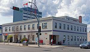
| Bank of Toronto |
7 Otto Drive, Yellowknife, NT |
62°28′12″N 114°20′38″W / 62.47°N 114.344°W / 62.47; -114.344 (Old Bank of Toronto Building) |
|
|
1239 |
Q19876356 |
.JPG)
More images |
| Hudsons Bay Warehouse |
3501 Wiley Road, Yellowknife, NT |
62°28′01″N 114°20′53″W / 62.467°N 114.348°W / 62.467; -114.348 (Hudson Bay Warehouse) |
|
|
1242 |
Q19874424 |
More images |
| Weaver & Devore Trading |
3535 Wiley Road, Yellowknife, NT |
62°27′53″N 114°21′00″W / 62.4648°N 114.35°W / 62.4648; -114.35 (Bullock's Fish and Chips) |
|
|
1244 |
Q7978348 |
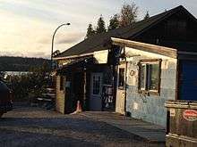
More images |
| Wildcat Cafe |
3509 Wiley Road, Yellowknife, NT |
62°28′00″N 114°20′56″W / 62.4666°N 114.349°W / 62.4666; -114.349 (Wildcat Cafe) |
|
|
1246 |
Q7774930 |
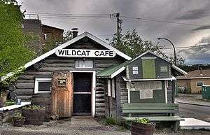
More images |
| Canadian Pacific Air Float Base |
3502 Wiley Road, Yellowknife, NT |
62°28′02″N 114°20′53″W / 62.4671°N 114.348°W / 62.4671; -114.348 (Canadian Pacific Float Base) |
|
|
1278 |
Q19876768 |
More images |
| Fireweed Studio |
5210 49th Avenue, Yellowknife, NT |
62°27′14″N 114°22′37″W / 62.4539°N 114.377°W / 62.4539; -114.377 (Fireweed Studio) |
|
|
1279 |
Q20006828 |
.JPG)
More images |
| Yellowknife Post Office |
4902 50th (Franklin) Avenue, Yellowknife, NT |
62°27′17″N 114°22′16″W / 62.4546°N 114.371°W / 62.4546; -114.371 (Yellowknife Post Office) |
|
|
10234 |
Q20006975 |
More images |
| School House |
5402 50th Avenue, Yellowknife, NT |
62°27′07″N 114°22′36″W / 62.4519°N 114.3767°W / 62.4519; -114.3767 (School House) |
|
|
1255 |
Q20006837 |
.JPG)
More images |
| Back Bay Cemetery |
, Yellowknife, NT |
62°28′11″N 114°21′54″W / 62.4697°N 114.365°W / 62.4697; -114.365 (Back Bay Cemetery) |
|
|
1280 |
Q19876343 |
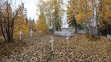
More images |
| Whalers' Graves |
Balaena Bay, Parry Peninsula, NT |
70°02′35″N 124°55′53″W / 70.0431°N 124.9314°W / 70.0431; -124.9314 (Whalers' Graves) |
|
1245 |
|
|
|
| Pokiak Territorial Historic Site |
Across Peel Channel from Aklavik, Pokiak, NT |
68°12′37″N 134°59′10″W / 68.21033°N 134.986°W / 68.21033; -134.986 (Pokiak Territorial Historic Site) |
|
17861 |
|
|
|
| Teetshik Goghaa (Old Arctic Red) Territorial Historic Site |
East bank of Mackenzie River 11km downstream from Tsiigehtchic, Tsiigehtchic, NT |
67°31′45″N 133°51′14″W / 67.5293°N 133.8540°W / 67.5293; -133.8540 (Teetshik Goghaa (Old Arctic Red) Territorial Historic Site) |
|
19345 |
|
|
|
| Nataiinlaii (Eight Miles) Territorial Historic Site |
Eight miles up the Peel River from Fort McPherson, Fort McPherson, NT |
67°20′01″N 134°51′59″W / 67.3335°N 134.8663°W / 67.3335; -134.8663 (Nataiinlaii (Eight Miles) Territorial Historic Site) |
|
19708 |
|
|
|
| Nagwichoo tshik (Mouth of the Peel) |
50km downstream from Fort McPherson on the south shore at the mouth of the Peel River, Fort McPherson, NT |
67°41′11″N 134°34′04″W / 67.6865°N 134.5678°W / 67.6865; -134.5678 (Nagwichoo tshik (Mouth of the Peel)) |
|
19709 |
|
|
|
| Old Fort Providence |
Wool Bay, Great Slave Lake, NT |
62°17′06″N 114°06′03″W / 62.2849°N 114.1007°W / 62.2849; -114.1007 (Old Fort Providence) |
|
19713 |
|
|
|