| Name |
Address |
Coordinates |
IDF |
IDP |
IDM |
 |
Image |
|---|
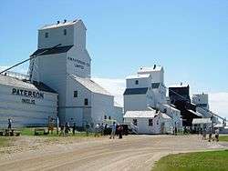
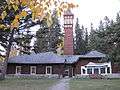
| Inglis Grain Elevators National Historic Site of Canada |
, Inglis, MB |
50°56′39″N 101°14′56″W / 50.9441°N 101.249°W / 50.9441; -101.249 (Inglis Grain Elevators National Historic Site of Canada) |
7875 |
|
|
|
More images |
| Ukrainian Greek Orthodox Church of the Ascension |
, Silver Creek, MB |
50°44′06″N 101°01′01″W / 50.7349°N 101.017°W / 50.7349; -101.017 (Ukrainian Greek Orthodox Church of the Ascension) |
|
|
9026 |
|
 |
| Lakedale Holy Ghost Ukrainian Catholic Church |
, Silver Creek, MB |
50°47′01″N 100°58′26″W / 50.7835°N 100.974°W / 50.7835; -100.974 (Lakedale Holy Ghost Ukrainian Catholic Church) |
|
|
14523 |
|
|
| Ukrainian People's Home of Ivan Franko |
Wright Avenue, Silver Creek, MB |
50°44′03″N 101°01′05″W / 50.7343°N 101.018°W / 50.7343; -101.018 (Ukrainian People's Home of Ivan Franko) |
|
|
2910 |
|
|
| Angusville Municipal Building |
235 Main Street, Silver Creek, MB |
50°44′03″N 101°01′12″W / 50.7343°N 101.02°W / 50.7343; -101.02 (Angusville Municipal Building) |
|
|
8235 |
|
|
| North American Lumber Co. Building |
162 - 2nd Street, Binscarth, MB |
50°37′33″N 101°17′13″W / 50.6259°N 101.287°W / 50.6259; -101.287 (North American Lumber Co. Building) |
|
|
3218 |
|
|
| Bank of Montreal Building |
5 Railway Avenue North, Ethelbert, MB |
51°32′N 100°24′W / 51.53°N 100.4°W / 51.53; -100.4 (Bank of Montreal Building) |
|
|
4174 |
|
|
| Ruskin School |
, Ethelbert, MB |
51°30′49″N 100°26′20″W / 51.5136°N 100.439°W / 51.5136; -100.439 (Ruskin School) |
|
|
8230 |
|
|
| Makaroff Hall |
, Shell River, MB |
51°21′03″N 101°30′29″W / 51.3509°N 101.508°W / 51.3509; -101.508 (Makaroff Hall) |
|
|
8455 |
|
|
| Ukrainian Greek Orthodox Church of St. John the Baptist |
, Ethelbert, MB |
51°39′16″N 100°27′36″W / 51.6545°N 100.46°W / 51.6545; -100.46 (Ukrainian Greek Orthodox Church of St. John the Baptist) |
|
|
8864 |
|
|
| Garland United Church |
, Ethelbert, MB |
51°39′09″N 100°27′36″W / 51.6525°N 100.46°W / 51.6525; -100.46 (Garland United Church) |
|
|
8865 |
|
|
| Toutes Aides Roman Catholic Church |
, Lawrence, MB |
51°29′13″N 99°32′00″W / 51.487°N 99.5333°W / 51.487; -99.5333 (Toutes Aides Roman Catholic Church) |
|
|
6262 |
|
|
| Ruthenian Greek Catholic Church of the Blessed Virgin Mary |
, Lawrence, MB |
51°27′17″N 99°31′38″W / 51.4547°N 99.5271°W / 51.4547; -99.5271 (Ruthenian Greek Catholic Church of the Blessed Virgin Mary) |
|
|
6264 |
|
|
| St. Margaret's Anglican Church |
112 Willow Avenue, Mountain (North), MB |
52°40′56″N 101°06′36″W / 52.6822°N 101.11°W / 52.6822; -101.11 (St. Margaret's Anglican Church) |
|
|
9025 |
|
|
| Griswold United Church |
Patterson Street, Sifton, MB |
49°43′34″N 100°31′12″W / 49.7261°N 100.52°W / 49.7261; -100.52 (Griswold United Church) |
|
4306 |
|
|
|
| Tummel United Church |
, Shell River, MB |
51°08′24″N 101°23′53″W / 51.1401°N 101.398°W / 51.1401; -101.398 (Tummel United Church) |
|
|
9441 |
|
|
| Horod School |
NE 22-19-21W, Park (South), MB |
50°39′07″N 100°18′00″W / 50.652°N 100.3°W / 50.652; -100.3 (Horod School) |
|
|
3749 |
|
|
| Sts. Peter and Paul Roman Catholic Church |
SE 7-19-21 WPM, Park (South), MB |
50°37′04″N 100°22′12″W / 50.6178°N 100.37°W / 50.6178; -100.37 (Sts. Peter and Paul Roman Catholic Church) |
|
|
4828 |
|
|
| Assumption of the Blessed Virgin Mary Ukrainian Catholic Church |
, Park (South), MB |
50°42′41″N 100°26′20″W / 50.7114°N 100.439°W / 50.7114; -100.439 (Assumption of the Blessed Virgin Mary Ukrainian Catholic Church) |
|
|
6256 |
|
|
| Ruthenian Greek Catholic Church of the Ascension |
, Park (South), MB |
50°38′19″N 100°10′16″W / 50.6387°N 100.171°W / 50.6387; -100.171 (Ruthenian Greek Catholic Church of the Ascension) |
|
|
6291 |
|
|
| Sts. Peter and Paul Ukrainian Orthodox Church |
, Park (South), MB |
50°40′57″N 100°29′06″W / 50.6826°N 100.485°W / 50.6826; -100.485 (Sts. Peter and Paul Ukrainian Orthodox Church) |
|
|
16347 |
|
|
| Sts. Peter and Paul Ukrainian United Church |
, Shellmouth-Boulton, MB |
51°00′27″N 101°12′50″W / 51.0075°N 101.214°W / 51.0075; -101.214 (Sts. Peter and Paul Ukrainian United Church) |
|
|
6533 |
|
|
| St. Elijah Romanian Orthodox Church |
SW 24-23-24 W, Shellmouth-Boulton, MB |
50°59′36″N 101°16′08″W / 50.9932°N 101.269°W / 50.9932; -101.269 (St. Elijah Romanian Orthodox Church) |
|
3907 |
|
|
|
| Inglis Grain Elevator Row |
Railway Avenue, Shellmouth-Boulton, MB |
50°56′39″N 101°14′49″W / 50.9442°N 101.247°W / 50.9442; -101.247 (Inglis Grain Elevator Row) |
|
4166 |
|
|
|
| Shellmouth United Church |
, Shellmouth-Boulton, MB |
50°56′00″N 101°28′41″W / 50.9334°N 101.478°W / 50.9334; -101.478 (Shellmouth United Church) |
|
|
5371 |
|
|
| Paulencu House |
, Shellmouth-Boulton, MB |
50°59′36″N 101°16′12″W / 50.9932°N 101.27°W / 50.9932; -101.27 (Paulencu House) |
|
6435 |
|
|
|
| Our Lady of Seven Sorrows Roman Catholic Church |
, Mountain (South), MB |
52°00′15″N 100°09′04″W / 52.0041°N 100.151°W / 52.0041; -100.151 (Our Lady of Seven Sorrows Roman Catholic Church) |
|
6266 |
|
|
|
| St. Michael's Ukrainian Catholic Church |
NW 20-26-20 WPM, Dauphin, MB |
51°16′12″N 100°14′56″W / 51.2701°N 100.249°W / 51.2701; -100.249 (St. Michael's Ukrainian Catholic Church) |
|
4107 |
|
|
|
| Elaschuk House |
, Roblin, MB |
51°13′45″N 101°15′07″W / 51.2292°N 101.252°W / 51.2292; -101.252 (Elaschuk House) |
|
4172 |
|
|
|
| Former Canadian Northern Railway Station |
126 First Avenue, Roblin, MB |
51°13′47″N 101°21′11″W / 51.2297°N 101.353°W / 51.2297; -101.353 (Former Canadian Northern Railway Station) |
6547 |
|
|
|
|
| South Bay School |
, Winnipegosis, MB |
51°40′59″N 100°03′04″W / 51.6831°N 100.051°W / 51.6831; -100.051 (South Bay School) |
|
|
6170 |
|
|
| Holy Resurrection Russian Orthodox Church |
Ogryzlo Street, Dauphin, MB |
51°21′37″N 100°08′20″W / 51.3602°N 100.139°W / 51.3602; -100.139 (Holy Resurrection Russian Orthodox Church) |
|
|
6259 |
|
|
| Tamarisk United Church |
, Grandview, MB |
50°11′46″N 100°38′53″W / 50.1961°N 100.648°W / 50.1961; -100.648 (Tamarisk United Church) |
|
5097 |
|
|
|
| Tamarisk School |
, Grandview, MB |
51°05′46″N 100°40′12″W / 51.0962°N 100.67°W / 51.0962; -100.67 (Tamarisk School) |
|
15281 |
6159 |
|
|
| Rhodes Community Hall |
, Dauphin, MB |
51°28′31″N 100°31′59″W / 51.4753°N 100.533°W / 51.4753; -100.533 (Rhodes Community Hall) |
|
|
8456 |
|
|
| Cromarty School |
, Roblin, MB |
51°13′40″N 101°28′08″W / 51.2278°N 101.469°W / 51.2278; -101.469 (Cromarty School) |
|
|
8457 |
|
|
| Ukrainian Greek Orthodox Church of Sts. Peter and Paul |
, Dauphin, MB |
51°00′48″N 100°12′11″W / 51.0133°N 100.203°W / 51.0133; -100.203 (Ukrainian Greek Orthodox Church of Sts. Peter and Paul) |
|
|
9422 |
|
|
| T.A. Burrows Mill Site |
, Grandview, MB |
51°10′47″N 100°42′47″W / 51.1797°N 100.713°W / 51.1797; -100.713 (T.A. Burrows Mill Site) |
|
|
11501 |
|
|
| Historic Ukrainian Catholic Church of the Resurrection |
1106 First Street SW, Dauphin, MB |
51°08′27″N 100°03′40″W / 51.1408°N 100.061°W / 51.1408; -100.061 (Historic Ukrainian Catholic Church of the Resurrection) |
|
3917 |
|
|
|
| Dauphin Canadian National Railway Station |
103 1st Avenue, Dauphin, MB |
51°09′00″N 100°03′04″W / 51.1499°N 100.051°W / 51.1499; -100.051 (Dauphin Canadian National Railway Station) |
|
3921 |
|
|
|
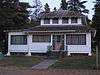
| Dauphin Town Hall |
104 1st Avenue NW, Dauphin, MB |
51°09′03″N 100°03′04″W / 51.1508°N 100.051°W / 51.1508; -100.051 (Dauphin Town Hall) |
|
3974 |
|
|
|
| Former Canadian Northern Railway Station |
101 1st Avenue NW, Dauphin, MB |
51°09′00″N 100°03′04″W / 51.15°N 100.051°W / 51.15; -100.051 (Former Canadian Northern Railway Station) |
6496 |
|
|
|

More images |
| Ukrainian Catholic Church of the Resurrection National Historic Site of Canada |
1106 First Street SW, Dauphin, MB |
51°08′31″N 100°03′43″W / 51.1419°N 100.062°W / 51.1419; -100.062 (Ukrainian Catholic Church of the Resurrection National Historic Site of Canada) |
12283 |
|
|
|
|
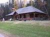
| Negrych Homestead |
SE 14-27-22 W, Gilbert Plains, MB |
51°18′24″N 100°27′07″W / 51.3066°N 100.452°W / 51.3066; -100.452 (Negrych Homestead) |
|
3912 |
|
|
|
| Gilbert Plains Beef Ring Building |
, Gilbert Plains, MB |
51°05′36″N 100°27′47″W / 51.0932°N 100.463°W / 51.0932; -100.463 (Gilbert Plains Beef Ring Building) |
|
|
8388 |
|
|
| Law Office Building |
510 Main Street, Swan River, MB |
52°06′20″N 101°16′12″W / 52.1056°N 101.27°W / 52.1056; -101.27 (Law Office Building) |
|
|
8395 |
|
|
| Satterthwaite House |
, McCreary, MB |
50°42′34″N 99°29′10″W / 50.7094°N 99.4862°W / 50.7094; -99.4862 (Satterthwaite House) |
|
|
5082 |
|
|
| Canal School |
Railway Street, McCreary, MB |
50°46′27″N 99°29′33″W / 50.7741°N 99.4925°W / 50.7741; -99.4925 (Canal School) |
|
|
5798 |
|
|
| Former Canadian Northern Railway Station |
Railway St. (between 1st and 2nd Ave.), McCreary, MB |
50°46′24″N 99°29′25″W / 50.7734°N 99.4902°W / 50.7734; -99.4902 (Former Canadian Northern Railway Station) |
6630 |
|
|
|
|
| Torsky Cabin |
, Rossburn, MB |
50°44′42″N 100°48′25″W / 50.7449°N 100.807°W / 50.7449; -100.807 (Torsky Cabin) |
|
|
6158 |
|
|
| Armstrong Farm Site |
, Rossburn, MB |
50°35′57″N 100°47′20″W / 50.5993°N 100.789°W / 50.5993; -100.789 (Armstrong Farm Site) |
|
|
6257 |
|
|
| Ukrainian Pioneer Mass Grave Site |
, Rossburn, MB |
50°38′28″N 100°35′38″W / 50.6412°N 100.594°W / 50.6412; -100.594 (Ukrainian Pioneer Mass Grave Site) |
|
|
6258 |
|
|
| Sts. Peter and Paul Ukrainian Catholic Church |
, Rossburn, MB |
50°41′57″N 100°40′34″W / 50.6992°N 100.676°W / 50.6992; -100.676 (Sts. Peter and Paul Ukrainian Catholic Church) |
|
|
6263 |
|
|
| Our Lady of the Assumption Roman Catholic Church |
, Rossburn, MB |
50°38′20″N 100°33′14″W / 50.639°N 100.554°W / 50.639; -100.554 (Our Lady of the Assumption Roman Catholic Church) |
|
|
6290 |
|
|
| Ukrainian Greek Orthodox Church of the Assumption of St. Mary |
, Rossburn, MB |
50°47′08″N 100°51′25″W / 50.7855°N 100.857°W / 50.7855; -100.857 (Ukrainian Greek Orthodox Church of the Assumption of St. Mary) |
|
|
6491 |
|
|
| Marconi School |
NW 23-20-23 WPM, Rossburn, MB |
50°44′24″N 100°34′34″W / 50.74°N 100.576°W / 50.74; -100.576 (Marconi School) |
|
|
3750 |
|
|
| St. Michael's Ukrainian Catholic Church |
, Rossburn, MB |
50°40′10″N 100°33′18″W / 50.6694°N 100.555°W / 50.6694; -100.555 (St. Michael's Ukrainian Catholic Church) |
|
|
6673 |
|
|
| Glen Elmo School |
, Rossburn, MB |
50°50′39″N 100°50′02″W / 50.8443°N 100.834°W / 50.8443; -100.834 (Glen Elmo School) |
|
|
6916 |
|
|
| Smellie Bros. and Co. Store |
300 Main Street, Russell, MB |
50°14′49″N 99°50′36″W / 50.2469°N 99.8433°W / 50.2469; -99.8433 (Smellie Bros. and Co. Store) |
|
|
2715 |
|
|
| Harley House |
515 2nd Street North, Swan River, MB |
52°06′20″N 101°15′54″W / 52.1056°N 101.265°W / 52.1056; -101.265 (Harley House) |
|
|
16348 |
|
|
| Superintendent's Residence and Works Garage |
Riding Mountain National Park, Wasagaming, MB |
50°40′33″N 99°54′51″W / 50.6757°N 99.9141°W / 50.6757; -99.9141 (Superintendent's Residence and Works Garage) |
3457 |
|
|
|
More images |
| Staff Residence Building B-15 |
150 Ta-wa-pit Drive, Riding Mountain National Park, Wasagaming, MB |
50°41′10″N 99°58′05″W / 50.686°N 99.968°W / 50.686; -99.968 (Staff Residence Building B-15) |
3459 |
|
|
|
More images |
| Warden's Station Residence No. 1, Building B-18 |
Riding Mountain National Park, Wasagaming, MB |
50°53′00″N 100°15′00″W / 50.8833°N 100.25°W / 50.8833; -100.25 (Warden's Station Residence No. 1, Building B-18) |
4271 |
|
|
|
|
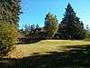
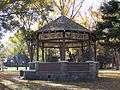
| Bandstand (B9) |
Riding Mountain National Park, Wasagaming, MB |
50°53′00″N 100°15′00″W / 50.8833°N 100.25°W / 50.8833; -100.25 (Bandstand (B9)) |
4278 |
|
|
|
More images |
| Superintendent's Residence |
, Wasagaming, MB |
50°41′10″N 99°58′05″W / 50.686°N 99.968°W / 50.686; -99.968 (Superintendent's Residence) |
3456 |
|
|
|
|
| Accountant's Residence |
154 Columbine Street, Wasagaming, MB |
50°53′00″N 100°15′00″W / 50.8833°N 100.25°W / 50.8833; -100.25 (Accountant's Residence) |
4276 |
|
|
|
More images |
| Casa Loma, Building (A2) |
154 Wasagaming Drive, Wasagaming, MB |
50°53′00″N 100°15′00″W / 50.8833°N 100.25°W / 50.8833; -100.25 (Casa Loma, Building (A2)) |
4280 |
|
|
|
More images |
| Jamboree Hall, Building B-10 |
, Wasagaming, MB |
50°53′00″N 100°15′00″W / 50.8833°N 100.25°W / 50.8833; -100.25 (Jamboree Hall, Building B-10) |
4282 |
|
|
|
|
| Tennis Clubhouse (B-6) |
Riding Mountain National Park, Wasagaming, MB |
50°53′00″N 100°15′00″W / 50.8833°N 100.25°W / 50.8833; -100.25 (Tennis Clubhouse (B-6)) |
4284 |
|
|
|
More images |
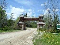
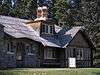
| Riding Mountain Park East Gate Registration Complex National Historic Site of Canada |
Norgate Road, Riding Mountain National Park, Wasagaming, MB |
50°41′00″N 99°33′19″W / 50.6833°N 99.5554°W / 50.6833; -99.5554 (Riding Mountain Park East Gate Registration Complex National Historic Site of Canada) |
10550 |
|
|
|
 |
| East Gate Entrance Building |
Highway 10, Riding Mountain National Park, Wasagaming, MB |
50°41′00″N 99°33′19″W / 50.6833°N 99.5554°W / 50.6833; -99.5554 (East Gate Entrance Building) |
9479 |
|
|
|
|
| Fire Hall (B-3) |
126 Tawapit Drive, Riding Mountain National Park, Wasagaming, MB |
50°53′00″N 100°15′00″W / 50.8833°N 100.25°W / 50.8833; -100.25 (Fire Hall (B-3)) |
9480 |
|
|
|
More images |
| Doctor’s Residence and Clinic (C5) |
140 Ta-wa-pit Drive, Wasagaming, MB |
50°53′00″N 100°15′00″W / 50.8833°N 100.25°W / 50.8833; -100.25 (Doctor’s Residence and Clinic (C5)) |
9483 |
|
|
|
More images |
| Golf Clubhouse (B7) |
Riding Mountain National Park, Wasagaming, MB |
50°53′00″N 100°15′00″W / 50.8833°N 100.25°W / 50.8833; -100.25 (Golf Clubhouse (B7)) |
9783 |
|
|
|
|
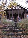
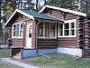
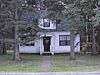
| Grey Owl's Cabin (B21) |
, Wasagaming, MB |
50°41′10″N 99°58′05″W / 50.686°N 99.968°W / 50.686; -99.968 (Grey Owl's Cabin (B21)) |
9915 |
|
|
|
|
| Royal Canadian Air Force Cottage (B16) |
, Wasagaming, MB |
50°53′00″N 100°15′00″W / 50.8833°N 100.25°W / 50.8833; -100.25 (Royal Canadian Air Force Cottage (B16)) |
9917 |
|
|
|
|
| Whirlpool Wardens' Residence |
Riding Mountain Park East Gate Registration Complex National Historic Site of Canada, Wasagaming, MB |
50°41′00″N 99°33′22″W / 50.6832°N 99.5562°W / 50.6832; -99.5562 (Whirlpool Wardens' Residence) |
9918 |
|
|
|
|
| Gate Keeper's Residence (B20) |
Riding Mountain National Park, Wasagaming, MB |
50°41′00″N 99°33′22″W / 50.6832°N 99.5562°W / 50.6832; -99.5562 (Gate Keeper's Residence (B20)) |
11181 |
|
|
|
|
| Interpretive Centre B1 |
Riding Mountain National Park, Wasagaming, MB |
50°53′00″N 100°15′00″W / 50.8833°N 100.25°W / 50.8833; -100.25 (Interpretive Centre B1) |
14829 |
|
|
|
 |
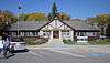
| Park Administration Building |
Riding Mountain National Park, Wasagaming, MB |
50°59′06″N 100°03′47″W / 50.9851°N 100.063°W / 50.9851; -100.063 (Park Administration Building) |
2888 |
|
|
|
More images |