Civil parishes in West Yorkshire
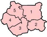
A civil parish is a subnational entity, forming the lowest unit of local government in England. There are 97 civil parishes in the ceremonial county of West Yorkshire, most of the county being unparished. At the 2001 census, there were 557,369 people living in the 97 parishes, accounting for 26.8 per cent of the county's population.
History
Parishes arose from Church of England divisions, and were originally purely ecclesiastical divisions. Over time they acquired civil administration powers.[1]
The Highways Act 1555 made parishes responsible for the upkeep of roads. Every adult inhabitant of the parish was obliged to work four days a year on the roads, providing their own tools, carts and horses; the work was overseen by an unpaid local appointee, the Surveyor of Highways.[2]
The poor were looked after by the monasteries, until their dissolution. In 1572, magistrates were given power to 'survey the poor' and impose taxes for their relief. This system was made more formal by the Poor Law Act 1601, which made parishes responsible for administering the Poor Law; overseers were appointed to charge a rate to support the poor of the parish.[3] The 19th century saw an increase in the responsibility of parishes, although the Poor Law powers were transferred to Poor Law Unions.[4] The Public Health Act 1872 grouped parishes into Rural Sanitary Districts, based on the Poor Law Unions; these subsequently formed the basis for Rural Districts.[5]
Parishes were run by vestries, meeting annually to appoint officials, and were generally identical to ecclesiastical parishes,[6] although some townships in large parishes administered the Poor Law themselves; under the Divided Parishes and Poor Law Amendment Act 1882, all extra-parochial areas and townships that levied a separate rate became independent civil parishes.[7]
Civil parishes in their modern sense date from the Local Government Act 1894, which abolished vestries; established elected parish councils in all rural parishes with more than 300 electors; grouped rural parishes into Rural Districts; and aligned parish boundaries with county and borough boundaries.[7] Urban civil parishes continued to exist, and were generally coterminous with the Urban District, Municipal Borough or County Borough in which they were situated; many large towns contained a number of parishes, and these were usually merged into one. Parish councils were not formed in urban areas, and the only function of the parish was to elect guardians to Poor Law Unions; with the abolition of the Poor Law system in 1930 the parishes had only a nominal existence.[8]
The Local Government Act 1972 retained civil parishes in rural areas, and many former Urban Districts and Municipal Boroughs that were being abolished, were replaced by new successor parishes; urban areas that were considered too large to be single parishes became unparished areas.[9]

The current position
Recent governments have encouraged the formation of town and parish councils in unparished areas, and the Local Government and Rating Act 1997 gave local residents the right to demand the creation of a new civil parish.[10]
A parish council can become a town council unilaterally, simply by resolution;[9] and a civil parish can also gain city status, but only if that is granted by the Crown.[9] The chairman of a town or city council is called a mayor.[9] The Local Government and Public Involvement in Health Act 2007 introduced alternative names: a parish council can now choose to be called a community; village; or neighbourhood council.[11]
List of civil parishes and unparished areas
Oct2008.jpg)


Jul2005.jpg)


_Aug_2006.jpg)
Nov2005.jpg)


See also
References
- ↑ Angus Winchester, 2000, Discovering Parish Boundaries. Shire Publications. Princes Risborough, 96 pages ISBN 978-0-7478-0470-3
- ↑ RAC Foundation : What Went Wrong? British Highway Development Before Motorways Retrieved 22 August 2009
- ↑ The Victorian Web : The Poor Law : Introduction Retrieved 22 August 2009
- ↑ Staffordshire University : Poor Law Unions and Registration Districts Archived 14 September 2012 at Archive.is Retrieved 22 August 2009
- ↑ A Vision of Britain Through Time : Status Details for Rural Sanitary District Retrieved 22 August 2009
- ↑ Robert Tittler, The Reformation and the Towns in England, 1998, Oxford University Press, 395 pages, ISBN 978-0-19-820718-4
- 1 2 Modern British Surnames : Selected Events in the History of Civil Registration and Boundary Changes 1801-1996 Archived 1 August 2010 at the Wayback Machine. Retrieved 22 August 2009
- ↑ Alex MacMorran and T R Colquhoun Dill, The Local Government Act 1894 and the Subsequent Statutes Affecting Parish Councils, 1907, Butterworth and Co, London, 626 pages
- 1 2 3 4 Office of Public Sector Information : Local Government Act 1972 Archived 5 December 2012 at Archive.is Retrieved 22 August 2009
- ↑ Office of Public Sector Information : Local Government and Rating Act 1997 Archived 5 August 2012 at Archive.is Retrieved 22 August 2009
- ↑ Office of Public Sector Information : Local Government and Public Involvement in Health Act 2007 Archived 5 August 2012 at Archive.is Retrieved 22 August 2009
- 1 2 A Vision of Britain Through Time : Skipton Rural District Archived 1 October 2007 at the Wayback Machine. Retrieved 1 September 2009
- 1 2 3 4 5 6 7 8 Office for National Statistics : Census 2001 : Parish Headcounts : Bradford Retrieved 1 September 2009
- ↑ A Vision of Britain Through Time : Baildon Urban District Retrieved 1 September 2009
- ↑ Office for National Statistics : Census 2001 : Table KS01 : Usual Resident Population Baildon; and Bingley (part) wards. Retrieved 26 August 2009
- 1 2 3 Office of Public Sector Information : The Bradford (Parish Electoral Arrangements) Order 2007 Retrieved 1 September 2009
- 1 2 3 4 A Vision of Britain Through Time : Bingley Urban District Retrieved 1 September 2009
- ↑ Office for National Statistics : Census 2001 : Table KS01 : Usual Resident Population Bingley (part); and Rombalds (part) wards. Retrieved 26 August 2009
- 1 2 3 4 A Vision of Britain Through Time : Bradford County Borough Retrieved 1 September 2009
- ↑ Office for National Statistics : Census 2001 : Table KS01 : Usual Resident Population Bolton (part); Bowling (part); Bradford Moor; Clayton (part); Eccleshill; Great Horton (part); Heaton (part); Idle; Little Horton (part); Odsal (part); Queensbury (part); Thornton; Toller; Tong; Undercliffe; University; Wibsey; and Wyke wards. Retrieved 26 August 2009
- 1 2 3 A Vision of Britain Through Time : Ilkley Urban District Retrieved 1 September 2009
- 1 2 Office for National Statistics : Census 2001 : Table KS01 : Usual Resident Population Rombalds (part) ward. Retrieved 26 August 2009
- 1 2 Office of Public Sector Information : The Bradford (Parish Electoral Arrangements) Order 2006 Retrieved 1 September 2009
- ↑ Office for National Statistics : Census 2001 : Table KS01 : Usual Resident Population Clayton (part); and Great Horton (part) wards. Retrieved 26 August 2009
- 1 2 3 4 Office of Public Sector Information : The Bradford (Parishes) Order 2004 Archived 19 May 2011 at the Wayback Machine. Retrieved 1 September 2009
- ↑ A Vision of Britain Through Time : Denholme Urban District Retrieved 1 September 2009
- ↑ Office for National Statistics : Census 2001 : Table KS01 : Usual Resident Population Bingley (part) ward. Retrieved 26 August 2009
- 1 2 3 A Vision of Britain Through Time : Keighley Municipal Borough Retrieved 1 September 2009
- ↑ Office for National Statistics : Census 2001 : Table KS01 : Usual Resident Population Ilkley; and Rombalds (part) wards. Retrieved 26 August 2009
- 1 2 a Vision of Britain Through Time : Queensbury and Shelf Urban District Archived 1 October 2007 at the Wayback Machine. Retrieved 2 September 2009
- ↑ Office for National Statistics : Census 2001 : Table KS01 : Usual Resident Population Queensbury (part) ward. Retrieved 26 August 2009
- ↑ Office for National Statistics : Census 2001 : Table KS01 : Usual Resident Population Heaton (part) ward. Retrieved 26 August 2009
- ↑ A Vision of Britain Through Time : Shipley Urban District Retrieved 2 September 2009
- ↑ Office for National Statistics : Census 2001 : Table KS01 : Usual Resident Population Shipley East (part); and Shipley West wards. Retrieved 26 August 2009
- ↑ A Vision of Britain Through Time : Silsden Urban District Retrieved 1 September 2009
- ↑ Office for National Statistics : Census 2001 : Table KS01 : Usual Resident Population Bowling (part); Little Horton (part); and Odsal (part) wards. Retrieved 26 August 2009
- ↑ Bradford City Council : The Bradford (Reorganisation of Community Governance) Order 2009 Retrieved 2 September 2009
- ↑ Office for National Statistics : Census 2001 : Table KS01 : Usual Resident Population Bingley Rural (part) ward. Retrieved 26 August 2009
- ↑ Office for National Statistics : Census 2001 : Table KS01 : Usual Resident Population Bolton (part); and Shipley East (part) wards. Retrieved 26 August 2009
- 1 2 3 4 A Vision of Britain Through Time : Hepton Rural District Retrieved 2 September 2009
- 1 2 3 4 5 6 7 Office for National Statistics : Census 2001 : Parish Headcounts : Calderdale Retrieved 2 September 2009
- ↑ A Vision of Britain Through Time : Brighouse Municipal Borough Retrieved 2 September 2009
- ↑ Office for National Statistics : Census 2001 : Table KS01 : Usual Resident Population Brighouse; Elland (part); Hipperholme and Lightcliffe; Rastrick; and Town (part) wards. Retrieved 26 August 2009
- ↑ A Vision of Britain Through Time : Elland Urban District Retrieved 2 September 2009
- ↑ Office for National Statistics : Census 2001 : Table KS01 : Usual Resident Population Elland (part); and Greetland and Stainland wards. Retrieved 26 August 2009
- ↑ A Vision of Britain Through Time : Halifax County Borough Retrieved 2 September 2009
- ↑ Office for National Statistics : Census 2001 : Table KS01 : Usual Resident Population Illingworth; Mixenden; Northowram and Shelf (part); Ovenden; Skircoat; St John's; Town (part); and Warley wards. Retrieved 26 August 2009
- ↑ A Vision of Britain Through Time : Hebden Royd Urban District Archived 14 May 2011 at the Wayback Machine. Retrieved 2 September 2009
- ↑ A Vision of Britain Through Time : Ripponden Urban District Retrieved 2 September 2009
- ↑ Office for National Statistics : Census 2001 : Table KS01 : Usual Resident Population Northowram and Shelf (part) ward. Retrieved 26 August 2009
- ↑ A Vision of Britain Through Time : Sowerby Bridge Urban District Retrieved 2 September 2009
- ↑ Office for National Statistics : Census 2001 : Table KS01 : Usual Resident Population Luddendenfoot (part); Ryburn (part); and Sowerby Bridge wards. Retrieved 2 September 2009
- ↑ A Vision of Britain Through Time : Todmorden Municipal Borough Retrieved 2 September 2009
- ↑ A Vision of Britain Through Time : Batley Municipal Borough Retrieved 3 September 2009
- ↑ Office for National Statistics : Census 2001 : Table KS01 : Usual Resident Population Batley East; Batley West (part); and Birstal and Birkenshaw (part) wards. Retrieved 26 August 2009
- ↑ A Vision of Britain Through Time : Colne Valley Urban District Archived 14 May 2011 at the Wayback Machine. Retrieved 3 September 2009
- ↑ Office for National Statistics : Census 2001 : Table KS01 : Usual Resident Population Colne Valley West; and Golcar (part) wards. Retrieved 26 August 2009
- ↑ A Vision of Britain Through Time : Denby Dale Urban District Retrieved 3 September 2009
- 1 2 3 4 5 Office for National Statistics : Census 2001 : Parish Headcounts : Kirklees Retrieved 3 September 2009
- ↑ A Vision of Britain Through Time : Dewsbury County Borough Retrieved 3 September 2009
- ↑ Office for National Statistics : Census 2001 : Table KS01 : Usual Resident Population Batley West (part); Dewsbury East; Dewsbury West (part); and Thornhill wards. Retrieved 26 August 2009
- ↑ A Vision of Britain Through Time : Heckmondwike Urban District Retrieved 3 September 2009
- ↑ Office for National Statistics : Census 2001 : Table KS01 : Usual Resident Population Heckmondwike (part) ward. Retrieved 26 August 2009
- ↑ A Vision of Britain Through Time : Holmfirth Urban District Archived 30 September 2007 at the Wayback Machine. Retrieved 3 September 2009
- ↑ A Vision of Britain Through Time : Huddersfield County Borough Archived 5 December 2007 at the Wayback Machine. Retrieved 3 September 2009
- ↑ Office for National Statistics : Census 2001 : Table KS01 : Usual Resident Population Almondbury; Birkby; Crosland Moor; Dalton (part); Deighton; Golcar (part); Lindley; Newsome; and Paddock wards. Retrieved 26 August 2009
- ↑ A Vision of Britain Through Time : Kirkburton Urban District Retrieved 3 September 2009
- ↑ A Vision of Britain Through Time : Meltham Urban District Retrieved 3 September 2009
- ↑ A Vision of Britain Through Time : Mirfield Urban District Retrieved 3 September 2009
- ↑ A Vision of Britain Through Time : Spenborough Municipal Borough Retrieved 3 September 2009
- ↑ Office for National Statistics : Census 2001 : Table KS01 : Usual Resident Population Birstal and Birkinshaw (part); Cleckheaton; Heckmondwike (part); and Spen wards. Retrieved 26 August 2009
- 1 2 3 4 5 6 7 8 9 10 11 A Vision of Britain Through Time : Tadcaster Rural District Archived 1 October 2007 at the Wayback Machine. Retrieved 8 September 2009
- 1 2 3 4 5 6 7 8 9 10 11 12 13 14 15 16 17 18 19 20 21 22 23 24 25 26 27 28 29 30 31 32 33 Office for National Statistics : Census 2001 : Parish Headcounts : Leeds Archived 19 March 2015 at the Wayback Machine. Retrieved 8 September 2009
- ↑ A Vision of Britain Through Time : Aireborough Urban District Archived 1 October 2007 at the Wayback Machine. Retrieved 8 September 2009
- ↑ Office for National Statistics : Census 2001 : Table KS01 : Usual Resident Population Aireborough; Horsforth (part); and Otley and Wharfedale (part) wards. Retrieved 26 August 2009
- 1 2 3 A Vision of Britain Through Time : Garforth Urban District Retrieved 8 September 2009
- 1 2 3 A Vision of Britain Through Time : Leeds County Borough Archived 13 February 2012 at the Wayback Machine. Retrieved 8 September 2009
- ↑ Office for National Statistics : Census 2001 : Table KS01 : Usual Resident Population North (part) ward. Retrieved 26 August 2009
- ↑ Department of Communities and Local Government : Bulletin of Changes to Local Authority Electoral Arrangements, Areas and Names in England : The Leeds (Parish) Order 2008 Archived 14 March 2012 at the Wayback Machine. Retrieved 8 September 2009
- 1 2 3 4 A Vision of Britain Through Time : Morley Municipal Borough Retrieved 8 September 2009
- ↑ Office for National Statistics : Census 2001 : Table KS01 : Usual Resident Population Morley South (part) ward. Retrieved 26 August 2009
- 1 2 3 4 A Vision of Britain Through Time : Wharfedale Rural District Archived 1 October 2007 at the Wayback Machine. Retrieved 8 September 2009
- 1 2 3 4 5 6 7 8 9 10 11 12 13 A Vision of Britain Through Time : Wetherby Rural District Archived 1 October 2007 at the Wayback Machine. Retrieved 9 September 2009
- 1 2 3 Office of the Deputy Prime Minister : Bulletin of Changes to Local Authority Areas and Names in England : The Leeds (Parishes) Order 2004 Archived 19 May 2011 at the Wayback Machine. Retrieved 9 September 2009
- ↑ Office for National Statistics : Census 2001 : Table KS01 : Usual Resident Population Morley North (part) ward. Retrieved 26 August 2009
- ↑ Office for National Statistics : Census 2001 : Table KS01 : Usual Resident Population Garforth and Swillington (part) ward. Retrieved 26 August 2009
- ↑ Office for National Statistics : Census 2001 : Table KS01 : Usual Resident Population Morley North (part) ward. Retrieved 26 August 2009
- ↑ A Vision of Britain Through Time : Horsforth Urban District Retrieved 9 September 2009
- ↑ Office for National Statistics : Census 2001 : Table KS01 : Usual Resident Population Barwick and Kippax (part) ward. Retrieved 26 August 2009
- ↑ Office for National Statistics : Census 2001 : Table KS01 : Usual Resident Population Armley; Beeston; Bramley; Burmantofts; Chapel Allerton; City and Holbeck; Cookridge; Halton (part); Harehills; Headingley; Hunslet; Kirkstall; Middleton (part); Moortown; North (part); Otley and Wharfedale (part); Richmond Hill; Roundhay (part); Seacroft; University; Weetwood; Whinmoor (part); and Wortley wards. Retrieved 26 August 2009
- ↑ A Vision of Britain Through Time : Otley Urban District Retrieved 10 September 2009
- ↑ "Pudsey MB/UD". www.visionofbritain.org.uk. Retrieved 5 May 2017.
- ↑ Office for National Statistics : Census 2001 : Table KS01 : Usual Resident Population Pudsey North; and Pudsey South wards. Retrieved 26 August 2009
- ↑ A Vision of Britain Through Time : Aireborough Urban District Archived 1 October 2007 at the Wayback Machine. Retrieved 8 September 2009
- ↑ Office for National Statistics : Census 2001 : Table KS01 : Usual Resident Population Aireborough; Horsforth (part); and Otley and Wharfedale (part) wards. Retrieved 26 August 2009
- ↑ "Bulletin of change to local authority arrangements, areas and names in England" (PDF). Local Government Boundary Commission for England. Archived from the original (PDF) on 12 January 2018. Retrieved 17 March 2018.
- ↑ A Vision of Britain Through Time : Rothwell Urban District Archived 6 May 2008 at the Wayback Machine. Retrieved 8 September 2009
- ↑ Office for National Statistics : Census 2001 : Table KS01 : Usual Resident Population Garforth and Swillington (part); Middleton (part); and Rothwell wards. Retrieved 26 August 2009
- 1 2 3 4 5 6 7 8 9 10 11 12 13 A Vision of Britain Through Time : Hemsworth Rural District Archived 1 October 2007 at the Wayback Machine. Retrieved 10 September 2009
- 1 2 3 4 5 6 7 8 9 10 11 12 13 14 15 16 17 18 19 20 21 22 23 24 25 26 27 28 29 30 Office for National Statistics : Census 2001 : Parish Headcounts : Wakefield Archived 13 June 2011 at the Wayback Machine. Retrieved 10 September 2009
- ↑ A Vision of Britain Through Time : Castleford Municipal Borough Retrieved 10 September 2009
- ↑ Office for National Statistics : Census 2001 : Table KS01 : Usual Resident Population Castleford Ferry Fryston; Castleford Glasshoughton; and Castleford Whitwood (part) wards. Retrieved 26 August 2009
- 1 2 3 4 5 6 7 8 9 10 11 12 A Vision of Britain Through Time : Wakefield Rural District Retrieved 10 September 2009
- 1 2 A Vision of Britain Through Time : Osgoldcross Rural District Retrieved 10 September 2009
- ↑ A Vision of Britain Through Time : Featherstone Urban District Retrieved 11 September 2009
- ↑ A Vision of Britain Through Time : Hemsworth Urban District Retrieved 11 September 2009
- ↑ A Vision of Britain Through Time : Horbury Urban District Retrieved 10 September 2009
- ↑ Office for National Statistics : Census 2001 : Table KS01 : Usual Resident Population Horbury (part) ward. Retrieved 26 August 2009
- ↑ A Vision of Britain Through Time : Knottingley Urban District Retrieved 10 September 2009
- ↑ Office for National Statistics : Census 2001 : Table KS01 : Usual Resident Population Knottingley ward. Retrieved 26 August 2009
- ↑ A Vision of Britain Through Time : Normanton Urban District Retrieved 11 September 2009
- ↑ A Vision of Britain Through Time : Ossett Municipal Borough Retrieved 10 September 2009
- ↑ Office for National Statistics : Census 2001 : Table KS01 : Usual Resident Population Horbury (part); and Ossett wards. Retrieved 26 August 2009
- ↑ A Vision of Britain Through Time : Pontefract Municipal Borough Retrieved 10 September 2009
- ↑ Office for National Statistics : Census 2001 : Table KS01 : Usual Resident Population Pontefract North; and Pontefract South (part) wards. Retrieved 26 August 2009
- ↑ A Vision of Britain Through Time : Stanley Urban District Archived 1 October 2007 at the Wayback Machine. Retrieved 10 September 2009
- ↑ Office for National Statistics : Census 2001 : Table KS01 : Usual Resident Population Stanley and Altofts (part); and Stanley and Wrenthorpe wards. Retrieved 26 August 2009
- ↑ A Vision of Britain Through Time : Wakefield County Borough Archived 16 May 2012 at the Wayback Machine. Retrieved 10 September 2009
- ↑ Office for National Statistics : Census 2001 : Table KS01 : Usual Resident Population Wakefield Central; Wakefield East; Wakefield North; and Wakefield South (part) wards. Retrieved 26 August 2009
External links
- Office for National Statistics : Geographical Area Listings
- City of Bradford Metropolitan District Council : Parish and Town Councils
- Calderdale Council : A Guide to Council Services : Parish and Town Councils
- Kirklees Council : Parish and Town Councils : Contact Your Local Council
- Leeds City Council : List of Town and Parish Council Clerks
- Wakefield Council : Town and Parish Contacts and Inspection Details