Map of Niger
This is a list of cities and towns in Niger. All larger cities are also Communes of Niger. While often translated as "town", Nigerien communes are simply the third level administrative subdivision of the nation. These can be classified Urban or Rural communes, and while often the administrative unit of a town or city, all areas of the country fall within a commune. Smaller towns and neighborhoods are designated Quarters (Urban) or Villages (Rural).
Largest cities and urban centers
.jpg)
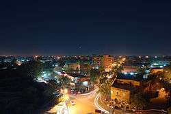
Zinder, the 2nd largest city of Niger.
Cities with population over 10,000 according to 2014 census.
| City |
Census division |
Population
2001[1] |
Position[2] |
| Abalak | Tahoua | 12,764 | 15°27′08″N 6°16′42″E / 15.4522222°N 6.2783333°E / 15.4522222; 6.2783333 |
| Agadez | Agadez | 78,289 | 16°58′26″N 7°59′27″E / 16.9738889°N 7.9908333°E / 16.9738889; 7.9908333 |
| Aguié | Maradi | 11,475 | 13°30′29″N 7°46′38″E / 13.5080556°N 7.7772222°E / 13.5080556; 7.7772222 |
| Arlit | Agadez | 69,435 | 18°43′57″N 7°22′05″E / 18.7325°N 7.3680556°E / 18.7325; 7.3680556 |
| Birni Ngaouré | Dosso | 10,775 | 13°05′16″N 2°55′01″E / 13.0877778°N 2.9169444°E / 13.0877778; 2.9169444 |
| Birni Nkonni | Tahoua | 44,663 | 13°48′N 5°15′E / 13.8°N 5.25°E / 13.8; 5.25 |
| Dakoro | Maradi | 18,875 | 13°49′00″N 6°25′00″E / 13.8166667°N 6.4166667°E / 13.8166667; 6.4166667 |
| Diffa | Diffa | 23,409 | 13°18′56″N 12°36′32″E / 13.3155556°N 12.6088889°E / 13.3155556; 12.6088889 |
| Dogondoutchi | Dosso | 29,244 | 13°38′46″N 4°01′44″E / 13.6461111°N 4.0288889°E / 13.6461111; 4.0288889 |
| Dosso | Dosso | 43,561 | 13°02′40″N 3°11′41″E / 13.0444444°N 3.1947222°E / 13.0444444; 3.1947222 |
| Filingué | Tillabéri | 11,661 | 14°21′00″N 3°19′00″E / 14.35°N 3.3166667°E / 14.35; 3.3166667 |
| Gaya | Dosso | 28,385 | 11°53′16″N 3°26′48″E / 11.8877778°N 3.4466667°E / 11.8877778; 3.4466667 |
| Gouré | Zinder | 13,422 | 13°59′13″N 10°16′12″E / 13.9869444°N 10.27°E / 13.9869444; 10.27 |
| Guidan Roumji | Maradi | 10,744 | 13°51′00″N 6°58′00″E / 13.85°N 6.9666667°E / 13.85; 6.9666667 |
| Illéla | Tahoua | 15,805 | 14°27′42″N 5°14′51″E / 14.4616667°N 5.2475°E / 14.4616667; 5.2475 |
| Kollo | Tillabéri | 10,533 | 13°18′31″N 2°19′51″E / 13.3086111°N 2.3308333°E / 13.3086111; 2.3308333 |
| Madaoua | Tahoua | 22,175 | 14°06′00″N 6°26′00″E / 14.1°N 6.4333333°E / 14.1; 6.4333333 |
| Magaria | Zinder | 17,776 | 14°34′00″N 8°44′00″E / 14.5666667°N 8.7333333°E / 14.5666667; 8.7333333 |
| Maïné-Soroa | Diffa | 10,176 | 13°13′04″N 12°01′36″E / 13.2177778°N 12.0266667°E / 13.2177778; 12.0266667 |
| Maradi | Maradi | 148,017 | 13°29′30″N 7°05′47″E / 13.4916667°N 7.0963889°E / 13.4916667; 7.0963889 |
| Matameye | Zinder | 17,930 | 13°25′26″N 8°28′40″E / 13.4238889°N 8.4777778°E / 13.4238889; 8.4777778 |
| Mirria | Zinder | 19,161 | 13°42′51″N 9°09′02″E / 13.7141667°N 9.1505556°E / 13.7141667; 9.1505556 |
| Nguigmi | Diffa | 15,922 | 14°15′10″N 13°06′39″E / 14.2527778°N 13.1108333°E / 14.2527778; 13.1108333 |
| Niamey | Niamey Capital District | 707,951 | 13°31′00″N 2°07′00″E / 13.5166667°N 2.1166667°E / 13.5166667; 2.1166667 |
| Say | Tillabéri | 10,502 | 13°06′29″N 2°21′35″E / 13.1080556°N 2.3597222°E / 13.1080556; 2.3597222 |
| Tahoua | Tahoua | 73,002 | 14°53′25″N 5°16′04″E / 14.8902778°N 5.2677778°E / 14.8902778; 5.2677778 |
| Tânout | Zinder | 15,779 | 14°58′13″N 8°53′30″E / 14.9702778°N 8.8916667°E / 14.9702778; 8.8916667 |
| Tchirozérine | Agadez | 10,032 | 17°15′37″N 7°45′03″E / 17.2602778°N 7.7508333°E / 17.2602778; 7.7508333 |
| Téra | Tillabéri | 19,508 | 14°00′38″N 0°45′11″E / 14.0105556°N 0.7530556°E / 14.0105556; 0.7530556 |
| Tessaoua | Maradi | 31,667 | 13°45′12″N 7°59′11″E / 13.7533333°N 7.9863889°E / 13.7533333; 7.9863889 |
| Tillabéri | Tillabéri | 16,683 | 14°12′22″N 1°27′12″E / 14.206146°N 1.453457°E / 14.206146; 1.453457 |
| Zinder | Zinder | 170,575 | 13°48′00″N 8°59′00″E / 13.8°N 8.9833333°E / 13.8; 8.9833333 |
External links
 Media related to Cities in Niger at Wikimedia Commons
|
|---|
| Sovereign states | |
|---|
States with limited
recognition | |
|---|
Dependencies and
other territories | |
|---|