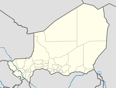
Agadez
| Agadez اغادیز | |
|---|---|
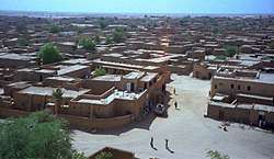 View of Agadez, from a minaret | |
 Agadez | |
| Coordinates: 16°58′0″N 7°59′0″E / 16.96667°N 7.98333°ECoordinates: 16°58′0″N 7°59′0″E / 16.96667°N 7.98333°E | |
| Country |
|
| Region | Agadez Region |
| Department | Tchirozerine Department |
| Commune | Agadez |
| Sultanate | 1449 CE |
| Government | |
| • Mayor | Rhissa Feltou |
| Elevation | 520 m (1,710 ft) |
| Population (2012 census) | |
| • Total | 118,244 |
| UNESCO World Heritage site | |
| Official name | Historic Centre of Agadez |
| Criteria | Cultural: ii, iii |
| Reference | 1268 |
| Inscription | 2013 (37th Session) |
| Area | 77.6 ha |
| Buffer zone | 98.1 ha |
Agadez, formerly spelled Agadès,[1] is the largest city in central Niger, with a population of 118,244 (2012 census). It lies in the Sahara and is the capital of Aïr, one of the traditional Tuareg–Berber federations. The city is also the capital of the Agadez Region. As of 2011, the urban commune had a total population of 124,324 people.[2]
History
The city was founded before the fourteenth century and gradually became the most important Tuareg city, supplanting Assodé, by growing around trans-Saharan trade. The city still sees the arrival of caravans, bringing salt from Bilma.
In 1449, Agadez became a sultanate, while around 1500 it was conquered by the Songhai Empire. At this point, the city had a population of around 30,000 people and was a key passage for the medieval caravans trading between the West African cities of Kano (and as a result Hausa language is the traditional lingua franca between different ethnic groups in the city, especially in the area of trade, religion and administration) and Timbuktu and the North African oases of Ghat, Ghadames, and Tripoli, on the Mediterranean shore. Decline set in after the Moroccan invasion, and the population sank to less than 10,000.
Some contend that Agadez was the farthermost point of the Ottoman Empire in the African continent until the 19th century before being occupied by the French colonial empire, though this claim has not been verified by historians.[3] The city was ruled by the French from 1900, though this claim has not been verified by historians. A rebellion by Kaocen Ag Mohammed occurred in 1916, but was defeated by French forces. Later, Agadez became an important location in the Tuareg Rebellion of the 1990s in central and northern Niger.
Culture and tourism
Today, Agadez flourishes as a market town and as a centre for the transportation of the uranium mined in the surrounding area. Notable buildings in the city include the Agadez Grand Mosque, originally dating from 1515 but rebuilt in the same style in 1844, the Kaocen Palace (now a hotel) and the Agadez Sultan's Palace. The city is also known for its camel market and its silver and leatherwork.
Some popular local musicians have found recognition in the west, like Tuareg guitar player Bombino and his band Group Bombino, Group Inerane and others. Mdou Moctar's film, Akounak Teggdalit Taha Tazoughai, is set and filmed on location in Agadez.[4]
Airport and U.S. drone airbase
Agadez Airport was named after Mano Dayak, the Tuareg leader who is native to the region.
The United States is building the Nigerien Air Base 201, a dedicated drone airbase in Agadez from which to more easily monitor terrorist activities in West and North Africa, in addition to extremists coming from the Sahel.[5][6] It was revealed in 2016 that the military base in Niger cost the U.S. Military US$100 million.[7]
2007 violence
As a result of the Second Tuareg Rebellion, sporadic violence and the displacement of numerous people affected the Agadez area from late 2007 into 2009. All of northern Niger was placed on the United States State Department list of areas which are unsafe for travel by United States citizens, covering late 2007 to the end of 2008. Tourist flights were also suspended to Agadez from European airlines for the 2007–2008 tourist season (September – March). The burgeoning tourist industry, which prior to 2007 had surpassed that of the Niamey and the rest of the nation, was essentially ended. The entire region was placed under a Niger government State of Exception (limiting travel, gatherings, political activities, etc.) in October 2007, renewed through early 2009. Roads to and from Agadez were reported to have been mined, and the Niger government closed the area to international journalists and aid organisations. An unknown number (reported as several thousands) of internally displaced people converged on the city as a result of the unrest.
Climate
| Climate data for Agadez, Niger | |||||||||||||
|---|---|---|---|---|---|---|---|---|---|---|---|---|---|
| Month | Jan | Feb | Mar | Apr | May | Jun | Jul | Aug | Sep | Oct | Nov | Dec | Year |
| Record high °C (°F) | 37 (99) |
40 (104) |
41 (106) |
47 (117) |
50 (122) |
46 (115) |
48 (118) |
43 (109) |
41 (106) |
40 (104) |
42 (108) |
40 (104) |
50 (122) |
| Average high °C (°F) | 27.9 (82.2) |
31.1 (88) |
35.0 (95) |
39.2 (102.6) |
41.3 (106.3) |
41.3 (106.3) |
39.1 (102.4) |
37.9 (100.2) |
38.9 (102) |
37.1 (98.8) |
32.4 (90.3) |
29.0 (84.2) |
35.8 (96.4) |
| Daily mean °C (°F) | 19.8 (67.6) |
22.5 (72.5) |
26.7 (80.1) |
31.2 (88.2) |
33.7 (92.7) |
33.8 (92.8) |
32.1 (89.8) |
31.0 (87.8) |
31.7 (89.1) |
29.4 (84.9) |
24.3 (75.7) |
21.0 (69.8) |
28.1 (82.6) |
| Average low °C (°F) | 11.7 (53.1) |
13.9 (57) |
18.3 (64.9) |
23.1 (73.6) |
26.0 (78.8) |
26.4 (79.5) |
25.1 (77.2) |
24.2 (75.6) |
24.5 (76.1) |
21.7 (71.1) |
16.2 (61.2) |
12.8 (55) |
20.3 (68.5) |
| Record low °C (°F) | −1 (30) |
7 (45) |
6 (43) |
13 (55) |
20 (68) |
19 (66) |
18 (64) |
17 (63) |
18 (64) |
12 (54) |
5 (41) |
−1 (30) |
−1 (30) |
| Average precipitation mm (inches) | 0.0 (0) |
0.0 (0) |
0.1 (0.004) |
2.0 (0.079) |
5.5 (0.217) |
10.4 (0.409) |
35.2 (1.386) |
49.7 (1.957) |
8.2 (0.323) |
0.3 (0.012) |
0.0 (0) |
0.0 (0) |
111.4 (4.386) |
| Mean monthly sunshine hours | 297.6 | 280.0 | 294.5 | 288.0 | 297.6 | 270.0 | 288.3 | 285.2 | 285.0 | 306.9 | 303.0 | 294.5 | 3,490.6 |
| Source #1: NOAA[8] | |||||||||||||
| Source #2: Weatherbase[9] | |||||||||||||
Neighborhoods
- Nasarawa, near the Agadez Mosque[10]
Notes
- ↑ "

- ↑ "Annuaires_Statistiques" (PDF). Institut National de la Statistique du Niger. Retrieved 2 May 2013.
- ↑ "Ottoman dynasty still alive in Africa - World Bulletin". worldbulletin.net. Retrieved 6 April 2018.
- ↑ "www.conceptoradio.net/2013/11/13/sahel-sounds-algunos-artistas-africanos-nunca-han-visto-un-vinilo/". conceptoradio. Retrieved 30 December 2013.
- ↑ "3 special forces troops are killed and 2 wounded in ambush in Niger". MSN.com.
- ↑ "Pentagon set to open second drone base in niger as it expands operations in Africa". The Washington Post.
- ↑ "U.S. MILITARY IS BUILDING A $100 MILLION DRONE BASE IN AFRICA". The Intercept. 29 September 2016.
- ↑ "Agadez AERO Climate Normals 1961–1990". National Oceanic and Atmospheric Administration. Retrieved 19 February 2015.
- ↑ "Agadez, Niger Weather Averages Summary". CantyMedia. Retrieved 20 April 2016.
- ↑ Taub, Ben (April 10, 2017). "The Desperate Journey of a Trafficked Girl". The New Yorker. Archived from the original on April 3, 2017.
Most Nigerian brothels in Agadez are in the Nasarawa slum, a sewage-filled neighborhood a short walk from the grand mosque, the tallest mud-brick structure in the world.
References
- Aboubacar Adamou. "Agadez et sa région. Contribution à l'étude du Sahel et du Sahara nigériens", Études nigériennes, n°44, (1979), 358 p.
- Julien Brachet. Migrations transsahariennes. Vers un désert cosmopolite et morcelé (Niger). Paris: Le Croquant, (2009), 324 p. ISBN 978-2-914968-65-2.
- Louis Werner. Agadez, Sultanate of the Sahara. Saudi Aaramco World, January/February 2003. Volume 54, Number 1.
- Samuel Decalo. Historical Dictionary of Niger. Scarecrow Press, London and New Jersey (1979). ISBN 0-8108-1229-0
- Jolijn Geels. Niger. Bradt London and Globe Pequot New York (2006). ISBN 1-84162-152-8.
- Berber Sultanate of Aïr worldstatesmen.org: Chronology of the Berber Sultanate of Aïr, based in Agadez.
External links
| Wikimedia Commons has media related to Agadez. |

- (in English) Audio interview with Agadez resident about life in Agadez. Great place
- http://www.agadez.org Site covering Northern Niger. Photo Gallery by Michel Batlle "portraits de femmes touarègues"
- interactive Map of the Agadez region.
- http://www.agadez-niger.com/ Site covering Agadez and Touareg culture.
- Agadez, the touareg capital of the nigerien region of Air
| Authority control |
|---|