Agadez Region
| Agadez Region | |
|---|---|
| Region | |
 | |
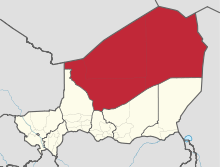 Location within Niger | |
| Coordinates: 17°0′N 8°0′E / 17.000°N 8.000°ECoordinates: 17°0′N 8°0′E / 17.000°N 8.000°E | |
| Country |
|
| Capital | Agadez |
| Government | |
| • Governor | Sadou Soloké |
| Area | |
| • Total | 667,799 km2 (257,839 sq mi) |
| Population (2012 census[1]) | |
| • Total | 487,620 |
| • Density | 0.73/km2 (1.9/sq mi) |
| Time zone | UTC+1 (West Africa Time) |

Agadez is an administrative Region in Niger. At 667,799 square kilometres (257,839 sq mi), Agadez is the largest subdivision of an African state. The capital of the department is Agadez.
Description and people
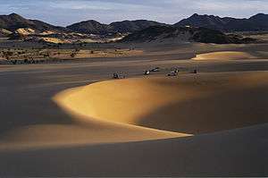
The Agadez Region represents 52% of the total area of Niger, the largest of its seven regions. Despite its size, Agadez is sparsely populated. Its 487,620 inhabitants account for only 2.8% of the total population of Niger with a population density of 0.73 inhabitants per square kilometre (1.9/sq mi). The region includes the vast Ténéré portion of the Sahara Desert, dune seas like the Erg of Bilma, and the mountains of the Aïr. Much of its population comprises nomadic or semi-nomadic peoples including the Tuareg, Toubou, Wadoobe Fula. There are populations of settled Kanuri (in the east), Hausa, and Songhay in the towns and oases.
Economy
Traversed for centuries by the Trans Saharan trade, the oasis towns of the Aïr and the eastern Kaouar Cliffs are known for their gardens, salt manufacture, and date cultivation. In the late 1990s, tourism became a large industry here, and the uranium town of Arlit provides some 20% of the foreign exchange for the country. Tuareg insurgencies against the Niger government in the 1990s and mid 2000s and drought in the 1970s, 80s, and 2002 have led to humanitarian crises and damaged the region's economy. Uranium mining is a prominent economic sector in the region with uranium pits and mines operated by foreign companies providing substantial revenue for the country. The French discovered Niger's first uranium deposits in the Tim Mersoi Basin of the Agadez Region in 1958 and since then French companies such as Areva have maintained a large footprint in the region, employing a large quantity of locals.[2][3]
Subdivisions
Agadez is divided into three Departments and one Commune.
| Commune | Size | Population | ||
|---|---|---|---|---|
| Agadez | ....... | 78 289 inhabitants | ||
| Department | Size | Population | Chief Town | Cantons |
| Arlit | 216 774 km2 | 98 170 inhabitants | Arlit | |
| Bilma | 296 279 km2 | 17 080 inhabitants | Bilma | Bilma, Djado, Fachi, Kawar |
| Tchirozérine | 154 746 km2 | 118 068 inhabitants | Tchirozérine |
Borders
Agadez has the following foreign borders, including Niger's only borders with Libya and Algeria:
- Kidal Region, Mali - west
- Tamanghasset Wilayah, Algeria - northwest
- Ghat, Libya - north
- Murzuq, Libya - northeast
- Bourkou-Ennedi-Tibesti Region, Chad - east
Domestically, it borders the following departments:
- Diffa Region - southeast
- Zinder Region - south, east of Maradi
- Maradi Region - south, west of Maradi
- Tahoua Region - southwest
See also
References
- ↑ Niger at Geohive Archived 2015-04-20 at the Wayback Machine.
- ↑ Michael Klare (13 March 2012). The Race for What's Left: The Global Scramble for the World's Last Resources. Henry Holt and Company. pp. 192–. ISBN 978-1-4299-7330-4.
- ↑ International Business Publications, USA (3 March 2008). Niger Mining Laws and Regulations Handbook. Int'l Business Publications. pp. 67–. ISBN 978-1-4330-7798-2.
External links
