List of World Heritage sites in Argentina


The United Nations Educational, Scientific and Cultural Organization (UNESCO) World Heritage sites are places of importance to cultural or natural heritage as described in the UNESCO World Heritage Convention, established in 1972.[1] Argentina accepted the UNESCO World Heritage Convention on 23 August 1978, making its historical sites eligible for inclusion on the list.[2]
Argentina had its first site included on the list at the 5th session of World Heritage Committee, held in Sydney, Australia, in October 1981. At that session, "Los Glaciares National Park" was inscribed on the list.[3] As of 2018, 2 elements have been inscribed on the Intangible cultural heritage[4] and 11 sites have been inscribed on the World Heritage List: 6 cultural sites and 5 natural sites. A further 9 sites have been proposed for inscription and are on the tentative list.[2]
World Heritage sites
- Name: as listed by the World Heritage Committee
- Location: Province where the site is located. If the site is a trans-border site the other countries will be listed in a note.
- Coordinates: geographic coordinates of the site's location
- Date of inscription: Year and session the site was added to the World Heritage list
- Criteria: The criteria it was listed under: criteria (i) through (vi) are cultural, while (vii) through (x) are natural
- Description: brief description of the site as listed by the World Heritage Committee
- ID: Reference number given by UNESCO
- ‡ Trans-border site
| Name | Image | Location | Coordinates | Date of Inscription | Criteria | Description | ID | Ref |
|---|---|---|---|---|---|---|---|---|
| Los Glaciares National Park | 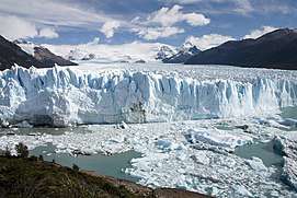 |
49°59′S 73°08′W / 49.99°S 73.14°W | 1981 (5th session) |
Natural (vii) (viii) |
"The Los Glaciares National Park is an area of exceptional natural beauty, with rugged, towering mountains and numerous glacial lakes, including Lake Argentino, which is 160 km (99 mi) long. At its farthest end, three glaciers meet to dump their effluvia into the milky grey glacial water, launching massive igloo icebergs into the lake with thunderous splashes". | 145 | [5] | |
| Jesuit Missions of the Guaranis: San Ignacio Mini, Santa Ana, Nuestra Señora de Loreto and Santa Maria Mayor‡ | 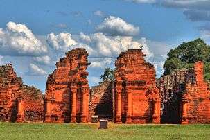 |
27°15′18″S 55°31′52″W / 27.255°S 55.531°W 27°23′28″S 55°34′52″W / 27.391°S 55.581°W 27°19′59″S 55°31′01″W / 27.333°S 55.517°W 27°53′20″S 55°20′42″W / 27.889°S 55.345°W |
1984[lower-alpha 2] (8th session) |
Cultural (iv) |
"The ruins [...] of San Ignacio Miní, Santa Ana, Nuestra Señora de Loreto and Santa María la Mayor in Argentina, lie at the heart of a tropical forest. They are the impressive remains of five Jesuit missions, built in the land of the Guaranis during the 17th and 18th centuries. Each is characterized by a specific layout and a different state of conservation". | 291-002 291-003 291-004 291-005 |
[8] | |
| Iguazú National Park | 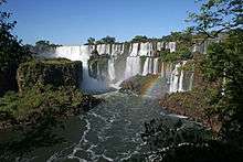 |
25°38′S 54°20′W / 25.64°S 54.34°W | 1984 (8th session) |
Natural (vii) (x) |
"The semicircular waterfall at the heart of this site is some 80 m (260 ft) high and 2,700 m (8,900 ft) in diameter and is situated on a basaltic line spanning the border between Argentina and Brazil. Made up of many cascades producing vast sprays of water, it is one of the most spectacular waterfalls in the world. The surrounding subtropical rainforest has over 2,000 species of vascular plants and is home to the typical wildlife of the region: tapirs, giant anteaters, howler monkeys, ocelots, jaguars and caimans". | 303 | [9] | |
| Cueva de las Manos, Río Pinturas | 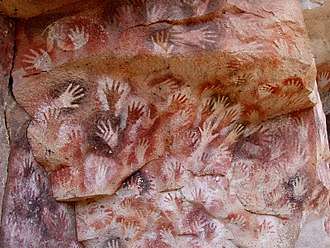 |
47°09′S 70°39′W / 47.15°S 70.65°W | 1999 (23rd session) |
Cultural (iii) |
"The Cueva de las Manos, Río Pinturas, contains an exceptional assemblage of cave art, executed between 13,000 and 9,500 years ago. It takes its name (Cave of the Hands) from the stencilled outlines of human hands in the cave, but there are also many depictions of animals, such as guanacos (Lama guanicoe), still commonly found in the region, as well as hunting scenes. The people responsible for the paintings may have been the ancestors of the historic hunter-gatherer communities of Patagonia found by European settlers in the 19th century". | 936 | [10] | |
| Península Valdés | 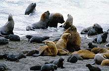 |
42°29′S 63°55′W / 42.48°S 63.91°W | 1999 (23rd session) |
Natural (x) |
"Península Valdés in Patagonia is a site of global significance for the conservation of marine mammals. It is home to an important breeding population of the endangered southern right whale as well as important breeding populations of southern elephant seals and southern sea lions. The orcas in this area have developed a unique hunting strategy to adapt to local coastal conditions". | 937 | [11] | |
| Ischigualasto / Talampaya Natural Parks | 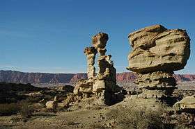 |
29°59′S 67°59′W / 29.98°S 67.98°W | 2000 (24th session) |
Natural (viii) |
"These two contiguous parks, extending over 275,300 ha (2,753 km2; 680,000 acres) in the desert region on the western border of the Sierras Pampeanas of central Argentina, contain the most complete continental fossil record known from the Triassic Period (245–208 million years ago). Six geological formations in the parks contain fossils of a wide range of ancestors of mammals, dinosaurs and plants revealing the evolution of vertebrates and the nature of palaeo-environments in the Triassic Period". | 966 | [12] | |
| Jesuit Block and Estancias of Córdoba | 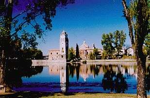 |
31°25′06″S 64°11′14″W / 31.4183°S 64.1872°W 31°39′28″S 64°26′06″W / 31.6577°S 64.4350°W 30°58′13″S 64°05′51″W / 30.9702°S 64.0974°W 30°52′11″S 64°14′02″W / 30.8698°S 64.2338°W 30°59′17″S 64°06′22″W / 30.9881°S 64.1060°W 31°05′52″S 64°51′19″W / 31.0978°S 64.8554°W |
2000 (24th session) |
Cultural (ii) (iv) |
"The Jesuit Block in Córdoba, heart of the former Jesuit Province of Paraguay, contains the core buildings of the Jesuit system: the university, the church and residence of the Society of Jesus, and the college. Along with the five estancias, or farming estates, they contain religious and secular buildings, which illustrate the unique religious, social, and economic experiment carried out in the world for a period of over 150 years in the 17th and 18th centuries". | 995-001 995-002 995-003 995-004 995-005 995-006 |
[13] | |
| Quebrada de Humahuaca | 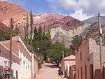 |
23°35′S 65°25′W / 23.59°S 65.41°W | 2003 (27th session) |
Cultural (ii) (iv) (v) |
"Quebrada de Humahuaca follows the line of a major cultural route, the Camino Inca, along the spectacular valley of the Rio Grande, from its source in the cold high desert plateau of the High Andean lands to its confluence with the Rio Leone some 150 km (93 mi) to the south. The valley shows substantial evidence of its use as a major trade route over the past 10,000 years. It features visible traces of prehistoric hunter-gatherer communities, of the Inca Empire (15th to 16th centuries) and of the fight for independence in the 19th and 20th centuries". | 1116 | [14] | |
| Qhapaq Ñan, Andean Road System‡ | _(2).jpg) |
23°22′0″S 64°58′0″W / 23.36667°S 64.96667°W 24°27′10″S 65°57′40″W / 24.45278°S 65.96111°W 24°35′35″S 66°02′07″W / 24.59306°S 66.03528°W 24°49′59″S 66°9′0″W / 24.83306°S 66.15000°W 24°42′59″S 68°31′30″W / 24.71639°S 68.52500°W 27°10′48″S 66°0′27″W / 27.18000°S 66.00750°W 27°42′30″S 66°0′0″W / 27.70833°S 66.00000°W 28°52′30″S 67°56′30″W / 28.87500°S 67.94167°W 30°3′0″S 69°10′30″W / 30.05000°S 69.17500°W 29°5′30″S 69°20′30″W / 29.09167°S 69.34167°W 32°6′0″S 69°21′59″W / 32.10000°S 69.36639°W 32°36′20″S 69°28′10″W / 32.60556°S 69.46944°W 32°49′35″S 69°54′40″W / 32.82639°S 69.91111°W |
2014 (38th session) |
Cultural (ii) (iii) (iv) (vi) |
"This site is an extensive Inca communication, trade and defence network of roads covering 30,000 km (19,000 mi). Constructed by the Incas over several centuries and partly based on pre-Inca infrastructure, this extraordinary network through one of the world’s most extreme geographical terrains linked the snow-capped peaks of the Andes—at an altitude of more than 6,000 m (20,000 ft)—to the coast, running through hot rainforests, fertile valleys and absolute deserts. It reached its maximum expansion in the 15th century, when it spread across the length and breadth of the Andes. The Qhapac Ñan, Andean Road System includes 273 component sites spread over more than 6,000 km (3,700 mi) that were selected to highlight the social, political, architectural and engineering achievements of the network, along with its associated infrastructure for trade, accommodation and storage, as well as sites of religious significance". | 1459-001 1459-002 1459-003 1459-004 1459-005 1459-006 1459-007 1459-008 1459-009 1459-010 1459-011 1459-012 1459-013 |
[15] | |
| The Architectural Work of Le Corbusier, an Outstanding Contribution to the Modern Movement‡ | 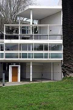 |
34°54′41″S 57°56′30″W / 34.911394°S 57.941739°W | 2016 (40th session) |
Cultural (i) (ii) (vi) |
"Chosen from the work of Le Corbusier, the 17 sites comprising this transnational serial property are spread over seven countries and are a testimonial to the invention of a new architectural language that made a break with the past. They were built over a period of a half-century, in the course of what Le Corbusier described as “patient research”. The Complexe du Capitole in Chandigarh (India), the National Museum of Western Art, Tokyo (Japan), the House of Dr Curutchet in La Plata (Argentina) and the Unité d'habitation in Marseille (France) reflect the solutions that the Modern Movement sought to apply during the 20th century to the challenges of inventing new architectural techniques to respond to the needs of society. These masterpieces of creative genius also attest to the internationalization of architectural practice across the planet". | 1321-011 | [16] | |
| Los Alerces National Park | .jpg) |
42°52′S 71°52′W / 42.87°S 71.87°W | 2017 (41st session) |
Natural (vii) (x) |
"The Los Alerces National park is located in the Andes of northern Patagonia and has a western boundary, which coincides with the Chilean border. Successive glaciations have moulded the landscape in the region creating spectacular features such as moraines, glacial cirques and clear-water lakes. The vegetation is dominated by dense temperate forests, which give way to alpine meadows higher up under the rocky Andean peaks. The property is vital for the protection of some of the last portions of continuous Patagonian Forest in an almost pristine state and is the habitat for a number of endemic and threatened species of flora and fauna". | 1526 | [17] |
Tentative list
In addition to the sites inscribed on the World Heritage list, member states can maintain a list of tentative sites that they may consider for nomination. Nominations for the World Heritage list are only accepted if the site was previously listed on the tentative list.[18] As of 2017, Argentina recorded 6 sites on its tentative list.[19]
- Name: as listed by the World Heritage Committee
- Location: Province where is located and geographic coordinates of the site
- Date of submission: Date the site was submitted to the Tentative List
- Criteria: The criteria it was listed under: criteria (i) through (vi) are cultural, while (vii) through (x) are natural
- Description: brief description of the site
- ID: Reference number given by UNESCO
| Name | Image | Location | Date of Submission | Criteria | Description | ID | Ref |
|---|---|---|---|---|---|---|---|
| Valle Calchaquí | 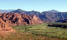 |
26°27′S 65°59′W / 26.45°S 65.98°W |
15 November 2001 | Cultural (ii) (iii) (iv) (v) (vi) |
"The Valle Calchaquí forms a 250 km (160 mi) narrow north-south strip along the Calchaquí river, between the structural units of La Puna and the Oriental Mountain Range. A bunch of secondary valleys and gorges, both longitudinal and transversal, build up the tributary system of the Calchaquí river. Las Conchas gorge is, in turn, a deep fluvial valley of 75 km (47 mi) long, that spreads from Alemania town to the joint of Calchaquí and Santa María. rivers." | 1582 | [20] |
| Sierra de las Quijadas National Park | 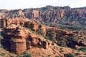 |
32°33′S 67°07′W / 32.55°S 67.12°W |
24 February 2005 | Natural (vii) (viii) (ix) |
"The Sierra de las Quijadas National Park undoubtedly constitutes a "sanctuary" of the flora and fauna of the province of San Luis and of the west-central part of Argentina, since its environment constitutes a transition strip or "ecotone" between the biogeographical provinces of Chaco and Monte. The sedimentary outcrops in Sierra de las Quijadas are part of a chain of geological units the detailed study of which has enabled to complement part of the geohistorical and paleobiological information of the Upper Mesozoic in Argentina, which extends over 120 million years (the entire Jurassic and Cretaceous Periods)." | 2021 | [21] |
| La Payunia, Campos Volcánicos Llancanelo y Payún Matrú | 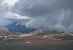 |
36°00′S 69°11′W / 36°S 69.19°W |
18 April 2011 | Natural (vii) (viii) |
"The proposed site includes two protected areas: the Provincial Reserves Llancanelo Lake and Payunia. The first has 90,000 ha (900 km2; 220,000 acres). of protected reserve, of which 65,000 ha (650 km2; 160,000 acres), have been declared a Ramsar site in 1996. It is one of the few areas in the country with a participatory management plan, developed jointly with the residents, and is unique in the world with volumetric limits. The Payunia Reserve covers 192,000 ha (1,920 km2; 470,000 acres) and is reserve since 1982, in the future will be expanded to 450,000 ha (4,500 km2; 1,100,000 acres) using available public land and other private lands with owners arrangement. In this part the volcanic territory reaches its peak focusing in its greater variety of volcanic landforms and creating a stunning landscape." | 5615 | [22] |
| Geological, Paleontological and Archaeological Provincial Reserve Pehuén Co–Monte Hermoso | 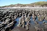 |
38°59′53″S 61°28′48″W / 38.998°S 61.480°W |
17 January 2014 | Mixed (iii) (v) (vi) (viii) (ix) |
"In this place, it is preserved, in a section carved by the marine ingression of the Holocene, a geological, paleontological and archeological record of exceptional characteristics. In an extension of about 25 km (16 mi), different sedimentary formations, whose age decreases from West to East, give us detailed information about the history of life and changes in the landscape over the last 5 million years. [...] For this reason, along some kilometers of beaches, which are enlightened with the rising and the setting of the sun of the Atlantic during summer, rocks evoke very different landscapes formed over time and have been inhabited by species living before and after the Great American Biotic Interchange (GABI)." | 5851 | [23] |
| Moisés Ville | 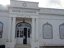 |
30°43′S 61°28′W / 30.71°S 61.47°W |
29 June 2015 | Cultural (ii) (iii) (vi) |
"In 1889, Moisés Ville, located in the province of Santa Fe, Argentina, was the first rural Jewish settlement to be established in the country. The first population was a group of families coming from the Podolia region, now in Ukraine.
Over the first half of the 20th Century, Moisés Ville became the most important Jewish village in Argentina and a centre of Jewish culture recognised at the international level; famous for its synagogues, theatre, Hebrew schools and academy, libraries and newspapers and magazines, in both Yiddish and Spanish. From the 1950s on, many descendants of the original settlers began leaving Moisés Ville, to seek higher education possibilities. Currently, the Jewish population in the village is some 10% of the total, but the testimonies to Jewish culture are present and alive, in both tangible and intangible components." |
6066 | [24] |
| ESMA Site Museum - Former Clandestine Centre of Detention, Torture, and Extermination | 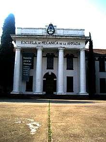 |
34°32′17″S 58°27′47″W / 34.538°S 58.463°W |
25 April 2017 | Cultural (iii) (vi) |
"The current ESMA Site Museum building, with a surface area of 5,390 m2 (58,000 sq ft) and located on the 16 ha (40 acres) property where the Navy School of Mechanics used to be, was inaugurated in 1946 as the Officers' Mess. The bedrooms of the highest-ranking officers in the Argentine Navy were in this building—an isolated pavilion rounded by gardens composed by a main building with three subordinated perpendicular blocks, with basements and a large attic.
Between 1976 and 1983, during the last military dictatorship, ESMA premises was a fundamental part of the repressive scheme whose epicentre was in this building, where the Clandestine Centre of Detention, Torture, and Extermination (CCDTyE) operated. Here, the Navy kidnapped, tortured and disappeared more than 5,000 men and women. The serious human rights violations, the systematic plan to steal children born in captivity, and the extermination of prisoners who were thrown alive into the sea during the so-called "flights of death" make this building a symbol of the genocide that took place in our country. It is incontrovertible proof of the State terrorism that inflicted extreme criminal violence on society at large." |
6248 | [25] |
| City of Tigre and its rowing clubs | 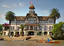 |
34°24′54″S 58°34′44″W / 34.415°S 58.579°W |
8 June 2017 | Cultural (ii) (iii) |
"The urban area of the city of Tigre next to the Tigre, Luján and Reconquista rivers constitutes an exceptional testimony to an urban settlement characterised by the presence of rivers and streams and with a tourism and sports vocation. [...] The establishment of rowing clubs between the end of the 19th Century and the beginning of the 20th by foreign communities that at that time arrived in Argentina made that Tigre reflected the cosmopolitan spirit of the country at that time.
The architectural components that testify to the development of the city of Tigre as a tourism centre and, especially, as a place for the practice of rowing, encompass the clubs themselves, vacations villas built between the end of 19th Century and the beginning of the 20th, and also buildings related to the services and tourism facilities. As an ensemble, this group of buildings constitutes an exceptional testimony to the architectural eclecticism prevailing in the period, including expressions that span from Italian academicism to the Modern Movement of the 20th Century. This eclecticism is noticeable not only in residential architecture but also in the rowing clubs, where, besides English styles typical of this kind of installations in other regions of the world, there are expressions related to Italian, French, Spanish and modern trends, which contribute to the exceptionality of the architectural ensemble and of the resulting urban landscape." |
6288 | [26] |
| Cueva de las Manos and associated sites of the Pinturas river basin | |
47°09′S 70°39′W / 47.15°S 70.65°W |
31 January 2018 | Cultural (iii) |
"Cueva de las Manos shows the main display of hunting scenes styles between 9400 and 6400 years BP, among the rock art of Pinturas river basin which has a vast time extension, between 9400 and 2000 years BP, as a genuine expression of the hunter-gatherers that started to populate Patagonia since 12000 years BP. The Charcamata style, for its part, appears after 5400 BP, it dominates the regional scene and represents the greater iconographic display, over Cueva de las Manos that shows few examples of this style.
This replication of the motifs on different sites such as El Puma 1, Cerro de los Indios, Cueva Grande del Arroyo Feo and Cueva de las Manos itself, shows the importance of Alero Charcamata as a node for the interpretation of rock art and for the territorial demarcation by these hunters in their seasonal nomadism, acquiring an exceptional value for the understanding of the regional rock art evolution, non the less because of the excellent preservation of their paintings." |
6297 | [27] |
| Buenos Aires – La Plata: Two capitals of the Culture of Modernity, Eclecticism and Immigration |  |
34°46′S 58°16′W / 34.76°S 58.26°W |
31 January 2018 | Cultural (ii) (iv) |
"The proposed heritage compilation is the highest expression of the prevailing eclecticism in the late nineteenth century and early twentieth century in most of the cities of the world. The eclecticism that took place in this area in the fields of architecture, engineering, urbanism, landscaping or decorative arts involved countless stylistic, technological, cultural and artistic combinations, led by the political, social and economic liberality, defined by the state legal system and the multicultural input of immigration." | 6296 | [28] |
Intangible Cultural Heritage
| Name | Image | Location | Date of Inscription | Description | Shared with | Ref |
|---|---|---|---|---|---|---|
| Tango‡ | 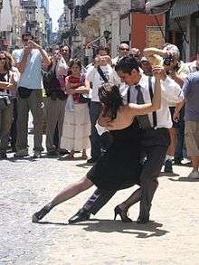 |
Rio de la Plata Basin | 2009 | "The Argentine and Uruguayan tradition of the Tango, now familiar around the world, was developed by the urban lower classes in Buenos Aires and Montevideo in the Rio de la Plata basin. Among this mix of European immigrants to the region, descendents of African slaves and the natives of the region known as criollos, a wide range of customs, beliefs and rituals were merged and transformed into a distinctive cultural identity. As one of the most recognizable embodiments of that identity, the music, dance and poetry of tango both embodies and encourages diversity and cultural dialogue. It is practised in the traditional dance halls of Buenos Aires and Montevideo, spreading the spirit of its community across the globe even as it adapts to new environments and changing times. That community today includes musicians, professional and amateur dancers, choreographers, composers, songwriters, teachers of the art and the national living treasures who embody the culture of tango. Tango is also incorporated into celebrations of national heritage in Argentina and Uruguay, reflecting the widespread embrace of this popular urban music." | [29] | |
| Filete porteño in Buenos Aires, a traditional painting technique | 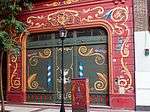 |
34°32′17″S 58°27′47″W / 34.538°S 58.463°W |
2015 | "Filete porteño from Buenos Aires is a traditional painting technique used for ornamental design that combines brilliant colours with specific lettering styles. It can be seen as a form of decoration on urban buses and trucks and is also used for store signage and increasingly, home decoration. Images used relate back to the city’s heritage incorporating social and religious elements, acting as a form of collective memory. Popular designs include icons representing saints, admired politicians, music and sports idols. Sayings and proverbs are sometimes also incorporated in the designs. The technique begins with a drawing, which is then transferred to a support. Synthetic paint, coloured varnish and special longhaired brushes are then used to complete the work. Filete craftsmen transmit this technique to anyone who wants to learn it. Formal education is not required to develop the skills needed, which represents an opportunity for some young people in the community who are at risk of social exclusion. In the last few decades, a new generation of craftswomen have participated in Filete workshops and the practice in general, producing a new aesthetic for the artform." | N/A | [30] |
See also
Notes
- ↑ Shared with Brazil.
- ↑ In 1984 the Brazilian Ruins of São Miguel das Missões, which had already been inscribed in 1983, was extended to include the Missions of San Ignacio Mini, Santa Ana, Nuestra Señora de Loreto and Santa Maria Mayor, making it a single trans-border site.[6][7]
- ↑ Shared with Bolivia, Chile, Colombia, Ecuador and Peru.
- ↑ Shared with Belgium, France, Germany, India, Japan and Switzerland.
References
- ↑ "The World Heritage Convention". Paris: UNESCO. Retrieved 24 September 2017.
- 1 2 "Argentina". Paris: UNESCO. Retrieved 24 September 2017.
- ↑ "WH Committee: 5th Session, Sydney 1981". Sydney: UNESCO. 26–30 October 1981. Retrieved 24 September 2017.
- ↑ "Browse the Lists of Intangible Cultural Heritage". Paris: UNESCO. Retrieved 24 September 2017.
- ↑ "Los Glaciares National Park". Paris: UNESCO. Retrieved 24 September 2017.
- ↑ "WH Committee: Report of 7th Session, Florence 1983". Florence: UNESCO. 5–9 December 1983. Retrieved 30 September 2017.
- ↑ "WH Committee: Report of the 8th Session, Buenos Aires 1984". Buenos Aires: UNESCO. 29 October – 2 November 1984. Retrieved 30 September 2017.
- ↑ "Jesuit Missions of the Guaranis: San Ignacio Mini, Santa Ana, Nuestra Señora de Loreto and Santa Maria Mayor (Argentina), Ruins of Sao Miguel das Missoes (Brazil)". Paris: UNESCO. Retrieved 24 September 2017.
- ↑ "Iguazu National Park". Paris: UNESCO. Retrieved 24 September 2017.
- ↑ "Cueva de las Manos, Río Pinturas". Paris: UNESCO. Retrieved 24 September 2017.
- ↑ "Península Valdés". Paris: UNESCO. Retrieved 24 September 2017.
- ↑ "Ischigualasto / Talampaya Natural Parks". Paris: UNESCO. Retrieved 24 September 2017.
- ↑ "Jesuit Block and Estancias of Córdoba". Paris: UNESCO. Retrieved 24 September 2017.
- ↑ "Quebrada de Humahuaca". Paris: UNESCO. Retrieved 24 September 2017.
- ↑ "Qhapaq Ñan, Andean Road System". Paris: UNESCO. Retrieved 24 September 2017.
- ↑ "The Architectural Work of Le Corbusier, an Outstanding Contribution to the Modern Movement". Paris: UNESCO. Retrieved 24 September 2017.
- ↑ "Los Alerces National Park". Paris: UNESCO. Retrieved 24 September 2017.
- ↑ "UNESCO World Heritage Centre - Tentative Lists". Paris: UNESCO. Retrieved 24 September 2017.
- ↑ "UNESCO World Heritage Centre - Tentative Lists: Argentina". Paris: UNESCO. Retrieved 24 September 2017.
- ↑ "Valle Calchaquí". Paris: UNESCO. Retrieved 24 September 2017.
- ↑ "Sierra de las Quijadas National Park". Paris: UNESCO. Retrieved 24 September 2017.
- ↑ "La Payunia, Campos Volcánicos Llancanelo y Payún Matrú". Paris: UNESCO. Retrieved 24 September 2017.
- ↑ "Geological, Paleontological and Archaeological Provincial Reserve Pehuén Co – Monte Hermoso". Paris: UNESCO. Retrieved 24 September 2017.
- ↑ "Moisés Ville". Paris: UNESCO. Retrieved 24 September 2017.
- ↑ "ESMA Site Museum - Former Clandestine Centre of Detention, Torture, and Extermination". Paris: UNESCO. Retrieved 24 September 2017.
- ↑ "City of Tigre and its rowing clubs". Paris: UNESCO. Retrieved 4 September 2018.
- ↑ "Cueva de las Manos and associated sites of the Pinturas river basin". Paris: UNESCO. Retrieved 4 September 2018.
- ↑ "Buenos Aires – La Plata: Two capitals of the Culture of Modernity, Eclecticism and Immigration". Paris: UNESCO. Retrieved 4 September 2018.
- ↑ "Tango". Paris: UNESCO. Retrieved 24 September 2017.
- ↑ "Filete porteño in Buenos Aires, a traditional painting technique". Paris: UNESCO. Retrieved 24 September 2017.
External links
| Wikimedia Commons has media related to World Heritage Sites in Argentina. |
- Argentina at UNESCO World Heritage Convention
| North America | ||
|---|---|---|
| Central America | ||
| The Caribbean |
| |
| South America | ||