Inca road system
| Inca road system | |
|---|---|
 Extent of the Inca road system | |
| Route information | |
| Length | 40,000 km (20,000 mi) |
| Time period | Pre-Columbian South America |
| UNESCO World Heritage site | |
| Official name | Qhapaq Ñan, Andean Road System |
| Criteria | Cultural: ii, iii, iv, vi |
| Reference | 1459 |
| Inscription | 2014 (38th Session) |
| Area | 11,406.95 ha |
| Buffer zone | 663,069.68 ha |
The Inca road system was the most extensive and advanced transportation system in pre-Columbian South America. It was about 39,900 kilometres (24,800 mi) long.[1]:242 The construction of the roads required a large expenditure of time and effort.[2]:634 The network was based on two north-south roads with numerous branches.[3] The best known portion of the road system is the Inca Trail to Machu Picchu. Part of the road network was built by cultures that precede the Inca Empire, notably the Wari culture. During the Spanish colonial era, parts of the road system were given the status of Camino Real. In 2014 the road system became a UNESCO World Heritage Site.[4]
The true extent of the road network is not completely known, since the Spaniards, post conquest, dug up the road completely in some areas, or allowed it to deteriorate and fall into ruin under iron-clad horses' hooves, or the metal wheels of ox-carts.[5] Only about 25 percent of this network is still visible. Different organizations such as UNESCO and IUCN have been working to protect the network in collaboration with the governments and communities of the six countries through which the Great Inca Road passes.
Main routes
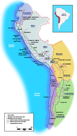
The eastern route ran high in the puna grasslands and mountain valleys from Quito, Ecuador to Mendoza, Argentina. The western route followed the coastal plain not including in coastal deserts where it hugged the foothills.[6] More than twenty routes ran over the western mountains, while others traversed the eastern cordillera in the mountains and lowlands. Some of these roads reach heights of over 5,000 metres (16,000 ft) above sea level.[1]:242 The trails connected the regions of the Inca empire from the northern provincial capital in Quito, Ecuador past the modern city of Santiago, Chile in the south. The Inca road system linked together about 40,000 kilometres (25,000 mi) of roadway[1]:242 and provided access to over 3,000,000 square kilometres (1,200,000 sq mi) of territory.
Situated between 500 to 800 metres (1,600 to 2,600 ft) above sea level, this monumental road, which could reach 20 metres (66 ft) in width, connected populated areas, administrative centres, agricultural and mining zones as well as ceremonial centres and sacred spaces.
Although the Inca roads varied greatly in scale, construction, and appearance, for the most part they varied between about 1 to 4 metres (3.3 to 13.1 ft) in width.[1]:245
Much of the system was the result of the Incas claiming exclusive right over numerous traditional routes, some of which had been constructed centuries earlier mostly by the Wari Empire. Many new sections were built or upgraded substantially: through Chile's Atacama desert, and along the western margin of Lake Titicaca, serve as two examples.[1]:242[7]:97 The Incas developed techniques to overcome the difficult territory of the Andes. On steep slopes they built stone steps resembling giant flights of stairs. In desert areas near the coast they built low walls to keep the sand from drifting over the road.[8]:301
The Qhapaq Ñan (English: Great Inca Road, or Main Andean Road, and meaning "the beautiful road"[5]) constituted the principal north-south highway of the Inca Empire traveling 6,000 kilometres (3,700 mi) along the spine of the Andes.
The Qhapaq Ñan unified this immense and heterogeneous empire through a well-organized political system of power. It allowed the Inca to control his Empire and to send troops as needed from the capital, Cusco.[9]
The most important Inca road was the Camino Real (Royal Road), as it is known in Spanish, with a length of 5,200 kilometres (3,200 mi). It began in Quito, Ecuador, passed through Cusco, and ended in what is now Tucumán, Argentina. The Camino Real traversed the mountain ranges of the Andes, with peak altitudes of more than 5,000 m (16,000 ft). El Camino de la Costa, the coastal trail, with a length of 4,000 kilometres (2,500 mi), ran parallel to the sea and was linked with the Camino Real by many smaller routes.
Purposes of the road
The Inca used the road system for a variety of purposes. Not only did the road simply provide transportation for people who were traveling through the empire, the road also provided many military and religious purposes for the Inca. Ordinary people were not allowed to travel along the roads for private purposes without official permission.[10]
Transportation
Much long-distance transportation was done on foot similar in Mesoamerica. The Inca had two main uses of transportation on the roads. They used the chasqui (runners) for relaying messages throughout the empire and llamas and alpacas for transporting goods.
The chasqui were known as the runners of the empire. They were estimated to run as much as 240 kilometers per day.[7]:243 Chasquis were in charge of delivering everything from news to lightweight goods such as fish.[11]:15 Tampu (also tambu, tampo), or way stations, were used as resting places for the chasquis as they made their journeys. Tampu were housing structures on the side of the road that provided water, supplies and shelter for the chasquis who passed by. They also had supplies for the military that were headed into battle.[11]:128
Llamas and alpacas were also used frequently. Llamas and alpacas are lightweight animals. They cannot carry much, but they are incredibly nimble. When transporting large amounts of goods across the empire it was more efficient for the Incas to use herds of llamas or alpacas and have two or three herdsmen.[7]:242 The herdsmen would herd the animals up the steep mountain roads without having to risk peoples' lives and while still being able to carry larger amounts of resources.[12]
Trade
Roads, trails, and bridges were essential to the political cohesion of the Inca state and to the redistribution of goods within it.[2]:632 All resources in the empire were the property of the ruling elite, the Inca.[13] The redistribution of these goods was known as vertical archipelago. This system was the basis for trade throughout the Inca empire.[7]:118 Different sections of the empire had different resources. The roads were used to send out the resources to other parts of the empire that were in need of them. This is one of the reasons the Inca empire was so powerful. They not only had a multitude of resources, but a set system to make sure all parts of the empire were able to obtain all the resources.[7]:120
Military
These roads provided easy, reliable and quick routes for the Empire's civilian and military communications, personnel movement, and logistical support. The prime users were imperial soldiers, porters and llama caravans, along with the nobility and individuals on official duty. Permission was required before others could walk along the roads, and tolls were charged at some bridges.[1]:242–43
Qollcas were used by the military and were situated along the roads. Qollcas were long term storage houses for foods in the event of conflicts or shortages in the Inca Empire.[8]:308 The qollcas were constructed with volcanic rock and built in a circular form. The bases were around or a little over 30 feet and almost 10 feet high with a conical thatched roof.[8]:312 They were used primarily for the storage of grains and maize. These were food items had an extremely long expiration date which made them ideal for long term storage for the military[14]
To give an example of the degree to which Incas stored supplies, one facility at Huánuco Pampa totaled as much as 37,100 cubic meters and could support a population of between twelve and fifteen thousand people.[13]
Religion
A high degree of energetic investment was put into the ritual purposes of the road. In Inca society, the mountains were objects of worship; the Incas held many rituals, including the sacrifice of children, goods, and llamas, at the tops of mountains. The only way for the Incas to reach the summits of the mountains for worship was by constructing roads. Many Inca roads went thousands of feet above sea level, such as mount Chañi, which had a road that started at the base and went to the summit, which was at a height of nearly six thousand feet.[15] In addition to high altitude shrines, there were also many holy shrines or religious sites, called wak’a, that were a part of the Zeq’e system along and near the roads. These shrines were either natural or modified features of the landscape, as well as buildings, where the Inca would visit for worship.[1]:163
Bridges
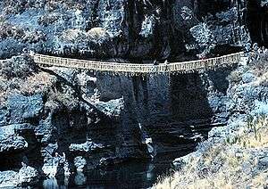
Various means were used to bridge water courses. There were multiple types of bridges used throughout the road system. Some bridges were made of simple logs, while others were built of stone or floating reeds were used in marshy highlands.[2]:632 Inca rope bridges also provided access across narrow valleys. Rafts were used to cross wide meandering rivers. A bridge across the Apurímac River, west of Cuzco, spanned a distance of 45 metres. Ravines were sometimes crossed by hanging baskets, or oroya, which could span distances of over 50 metres. Bridges were sometimes built in pairs.[1]:245–46
One of the difficulties of creating bridges was obtaining wood. Sometimes, the laborers who were making the bridges had to bring the lumber from very far away. In places where they had no timber, bridges would be built from ropes made of straw and grasses. If the bridges were made from rope, they had to be replaced about every two years, then they would burn it down. While if they were made from wood, they would not have to be replaced for about eight years.[2]:637
The construction of these bridges was accomplished by the help of many workers. For simple log bridges, the construction was done by placing a series of logs over projecting canes.[2]:632 The construction of stone bridges was more complicated. The stone wall foundations for bridges were built with both rough and dressed stone. The masonry is extremely well fitted, with no evidence of any mortar being used to keep the stones in place.[2]:638 Rather, they used a method of stone working which used simple tools, such as hammerstones, to pound the rocks in a way that the contours of the upper rock matched those of the rock below so that the seams fit perfectly without mortar.[1]:310
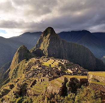
Inca Trail to Machu Picchu
Machu Picchu itself was far off the beaten path,[16] and served as a royal estate populated by the ruling Inca and several hundred servants. It required regular infusions of goods and services from Cuzco and other parts of the empire. This is evidenced by the fact that there are no large government storage facilities (qullqas) at the site. A 1997 study concluded that the site's agricultural potential would not have been sufficient to support residents, even on a seasonal basis.[17]
See also
References
- 1 2 3 4 5 6 7 8 9 D'Altroy, Terence N. (2002). The Incas. Blackwell Publishers Inc. ISBN 0-631-17677-2.
- 1 2 3 4 5 6 Thompson, Donald E.; John V. Murra (July 1966). "The Inca Bridges in the Huanuco Region". Society for American Archaeology. 5. 31 (1).
- ↑ History of the Inca realm. Cambridge, England: Cambridge University Press. 1999. p. 60. ISBN 0-521-63759-7.
- ↑ "How the Inca Empire Engineered a Road Across Some of the World's Most Extreme Terrain". Smithsonianmag.com. Retrieved 2015-07-01.
- 1 2 Cameron, Ian (1990). Kingdom of the Sun God: a history of the Andes and their people. New York: Facts on File. p. 65. ISBN 0-8160-2581-9.
- ↑ Incas: lords of gold and glory. New York: Time-Life Books. 1992. pp. 94–97. ISBN 0-8094-9870-7.
- 1 2 3 4 5 D'Altroy, Terence N. (1992). Provincial Power in the Inka Empire. Smithsonian Institution. ISBN 1-56098-115-6.
- 1 2 3 Vergara, Teresa (2000). Historia del Peru, Tahuantinsuyu. Spain: Lexus Editores. ISBN 9972-625-35-4.
- ↑ "Main Andean Road – Qhapaq Ñan". UNESCO. Retrieved 2009-07-10.
- ↑ "The Inca Road System". Ancient.eu. Retrieved 19 November 2017.
- 1 2 Rugeles, Ernesto F (1979). Indian Traditions Series: The chasqui : an Inca tradition. ISBN 0832502634.
- ↑ "Main Andean Road – Qhapaq Nan". UNESCO. 10 July 2009.
- 1 2 Jenkins, David (2001). "Network Analysis of Inka Roads, Administrative Centers, and Storage Facilities" (Volume 48 ed.). Duke University Press. p. 659.
- ↑ Fellman, Bruce (2002). "Rediscovering Mach Picchu". Yale Alumni Magazine.
- ↑ Vitry, Christian (2007). "Roads for Rituals and Sacred Mountains. A study of the Inka Road Systems in High Altitude Shrines in the North". Bulletin of the Chilean Museum of Pre-Columbian Art. p. 2.
- ↑ "Rediscovering Machu Picchu" by Bruce Fellman, Yale Alumni Magazine (December 2002)
- ↑ Life Styles of the Rich and Famous: Luxury and Daily Life in the Households of Machu Picchu's Elite. Lucy C. Salazar and Richard L. Burger."Archived copy" (PDF). Archived from the original (PDF) on 2008-12-19. Retrieved 2008-12-19.
Bibliography
- Cameron, Ian (1990). Kingdom of the Sun God: a history of the Andes and their people. New York: Facts on File. p. 65. ISBN 0-8160-2581-9.
- D'Altroy, Terence N (1992). Provincial Power in the Inka Empire. Smithsonian Institution. ISBN 1-56098-115-6.
- D'Altroy, Terence N. (2002). The Incas. Blackwell Publishers. ISBN 0-631-17677-2.
- Fellman, Bruce (2002). "Rediscovering Mach Picchu". Yale Alumni Magazine.
- Inca: Lords of Gold and Glory. New York, New York: Time-Life Books. 1992. ISBN 0-8094-9870-7.
- Jenkins, David (2001). "Network Analysis of Inka Roads, Administrative Centers, and Storage Facilities" (Volume 48 ed.). Duke University Press. pp. 655–87.
- "Main Andean Road – Qhapaq Nan". UNESCO. 10 July 2009.
- Rostworowski de Diez Canseco, Maria; Harry B. Iceland (1999). History of the Inca realm. Cambridge, UK: Cambridge University Press. ISBN 0-521-63759-7.
- Rugeles, Ernesto F (1979). SeriesIndian Traditions : The chasqui : an Inca tradition. ISBN 0832502634.
- Salazar, Lucy C.; Richard L. Burger (2004). Lifestyles of the Rich and Famous: Luxury and Daily Life in the Households of Machu Picchu's Elite. Dumbarton Oaks.
- Thompson, Donald E.; John V. Murra (July 1966). "The Inca Bridges in the Huanuco Region". American Antiquity. 5. Society for American Archaeology. 31 (1): 632–39. doi:10.2307/2694488.
- Vergara, Teresa (2000). Historia del Peru, Tahuantinsuyu. Spain: Lexus Editores. p. 301. ISBN 9972-625-35-4.
- Vitry, Christian (2007). "Roads for Rituals and Sacred Mountains. A study of the Inka Road Systems in High Altitude Shrines in the North". Bulletin of the Chilean Museum of Pre-Columbian Art.
Further reading
- Moseley, Michael 1992. The Incas and their Ancestors: The archaeology of Peru. Thames and Hudson, New York.
- Hyslop, John, 1984. Inka Road System. Academic Press, New York.
- Andean World: Indigenous History: Culture and Consciousness by Kenneth Adrien.
- Footprints Cusco and The Inca Trail Handbook by Peter Frost and Ben Box
- Jenkins, David. "A Network Analysis of Inka Roads, Administrative Centers and Storage Facilities." Ethnohistory, 48:655–685 (Fall, 2001).
External links
| Wikimedia Commons has media related to Camino Inca. |
- Trailer: "Qhapaq Ñan, Voices of the Andes"
- Geographic database of the inca road system from a French university
- Article: "Reinventing the Inca roads: Representations and construction of memory in Peru (2001–2011)"
- UNESCO World Heritage Centre – Main Inca Road – Qhapaq Ñan
| Northwest | ||
|---|---|---|
| Mesopotamia |
| |
| Cuyo | ||
| Pampas | ||
| Patagonia | ||