List of World Heritage sites in the Caribbean
This is a list of UNESCO World Heritage sites in the Caribbean. The Netherlands through Curaçao has been included here as part of North America because the island is situated in the Caribbean. Also, although not in the Caribbean, the islands of Bermuda are also included.
Legend
- Site; as per officially inscribed name[1]
- Location; at city, regional, or provincial level and geocoordinates
- Criteria; as defined by the World Heritage Committee[2]
- Area; in hectares and acres. If available, the size of the buffer zone has been noted as well. A value of zero implies that no data has been published by UNESCO
- Year; during which the site was inscribed to the World Heritage List
- Description; brief information about the site, including reasons for qualifying as an endangered site, if applicable
World Heritage sites
† In danger
* Trans-border site
| Site | Image | Location | Criteria | Area ha (acre) |
Year | Description | Refs |
|---|---|---|---|---|---|---|---|
| Alejandro de Humboldt National Park | 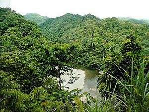 |
Holguín and Guantánamo, 20°27′N 75°0′W / 20.450°N 75.000°W |
Natural: (ix), (x) |
69,341 (171,350); buffer zone 34,330 (84,800) | 2001 | The park exhibits a wide array of geology types. It contains many biological species, including 16 of Cuba's 28 endemic plant species, as well as animal species such as the endangered Cuban solenodon. | [3] [4] |
| Antigua Naval Dockyard and Related Archaeological Sites | 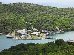 |
English Harbour, Antigua, 17°00′30″N 61°45′52″W / 17.00833°N 61.76444°W |
Cultural: (ii), (iv) |
255 (630); buffer zone 3,873 (9,570) | 2016 | The site consists of a group of Georgian-style naval buildings and structures, set within a walled enclosure. The natural environment of this side of the island of Antigua, with its deep, narrow bays surrounded by highlands, offered shelter from hurricanes and was ideal for repairing ships. The construction of the Dockyard by the British navy would not have been possible without the labour of generations of enslaved Africans since the end of the 18th century. Its aim was to protect the interests of sugar cane planters at a time when European powers were competing for control of the Eastern Caribbean. | [5] |
| Archaeological Landscape of the First Coffee Plantations in the South-East of Cuba | 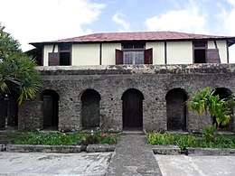 |
Santiago de Cuba and Guantánamo, 20°00′21″N 75°37′4″W / 20.00583°N 75.61778°W |
Cultural: (iii), (iv) |
81,475 (201,330) | 2000 | During the 19th and early 20th centuries, eastern Cuba was primarily involved with coffea cultivation. The remnants of the plantations display the techniques used in the difficult terrain, as well as the economic and social significance of the plantation system in Cuba and the Caribbean. | [5] |
| Blue and John Crow Mountains | 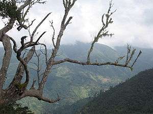 |
18°04′39″N 76°34′16″W / 18.077500°N 76.571111°W |
Mixed: (iii), (vi), (x) |
26,252 (64,870); buffer zone 28,494 (70,410) | 2015 | The park is so large that it covers roughly about 4.5% of Jamaica. | [6] |
| Brimstone Hill Fortress National Park | 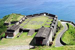 |
Saint Kitts, 17°20′49″N 62°50′14″W / 17.34694°N 62.83722°W |
Cultural: (iii), (iv) |
— | 1999 | Built during the 17th and 18th centuries by African slaves in a period of European colonial expansion, the fortress is an exceptionally well preserved example of British military architecture in the Caribbean. | [7] |
| Colonial City of Santo Domingo | 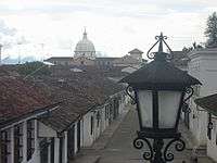 |
Distrito Nacional, 18°29′0″N 69°55′0″W / 18.48333°N 69.91667°W |
Cultural: (ii), (iv), (vi) |
93 (230) | 1990 | Santo Domingo was founded in 1498 shortly after the arrival of Christopher Columbus on the island and had the first cathedral, hospital, customs house and university built in the New World. Its grid patterned town plan became the model for other colonial towns in the Americas. | [8] |
| Desembarco del Granma National Park | 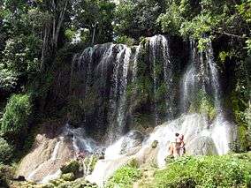 |
Granma, 19°53′N 77°38′W / 19.883°N 77.633°W |
Natural: (vii), (viii) |
32,576 (80,500) | 1999 | The park features a unique karst topography with features such as terraces, cliffs, and waterfalls. | [9] [10] |
| Historic Area of Willemstad, Inner City and Harbour, Curaçao | 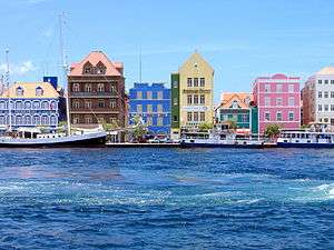 |
Willemstad, 12°6′7″N 68°54′8″W / 12.10194°N 68.90222°W |
Cultural: (ii), (iv), (v) |
86 (210); buffer zone 87 (210) | 1997 | The architecture of the 17th-century Dutch trading settlement Willemstad combines styles from the Netherlands with Spanish and Portuguese colonial towns. | [11] |
| Historic Bridgetown and its Garrison | %2C_Barbados.jpg) |
Bridgetown 13°5′48″N 59°36′50″W / 13.09667°N 59.61389°W |
Cultural: (ii), (iii), (iv) |
187 (460); buffer zone 321 (790) | 2011 | Bridgetown is an excellent example of a British colonial settlement built from the 17th to 19th century. Unlike Dutch and Spanish settlements of the area, the town is not laid out on a grid plan but follows a serpentine urban design. | [12] |
| Historic Centre of Camagüey | 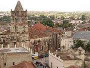 |
Camagüey, 21°22′43″N 77°55′7″W / 21.37861°N 77.91861°W |
Cultural: (iv), (v) |
54 (130); buffer zone 276 (680) | 2008 | Camagüey is among the first seven villages founded by the Spanish in Cuba, first settled in 1528. The irregular organization of the city is distinct from the typical, orderly construction of most other Spanish settlements. This maze-like style was influenced by medieval European ideas and traditional construction methods of early immigrant masons and construction workers. | [13] |
| Historic Town of St George and Related Fortifications, Bermuda | 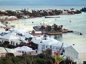 |
St. George 32°22′46″N 64°40′40″W / 32.37944°N 64.67778°W |
Cultural: (iv) |
258 (640) | 2000 | The oldest English town in the New World, St George's fortifications bear testimony to the development of English military architecture from the 17th to 20th centuries. | [14] |
| La Fortaleza and San Juan National Historic Site in Puerto Rico | 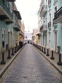 |
San Juan 18°28′0″N 66°7′30″W / 18.46667°N 66.12500°W |
Cultural: (vi) |
33 (82) | 1983 | A series of defensive structures built between the 16th and 20th centuries at a strategic point in the Caribbean Sea to protect the city and the Bay of San Juan. They represent a fine display of European military architecture adapted to harbour sites on the American continent. | [15] |
| Morne Trois Pitons National Park | 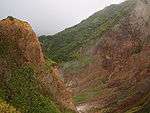 |
south central part of the island, 15°16′N 61°17′W / 15.267°N 61.283°W |
Natural: (viii), (x) |
6,857 (16,940) | 1997 | [16] | |
| National History Park – Citadel, Sans Souci, Ramiers | 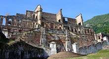 |
Nord, 19°34′25″N 72°14′39″W / 19.57361°N 72.24417°W |
Cultural: (iv), (vi) |
— | 1982 | [17] | |
| Old Havana and its Fortifications | .jpg) |
La Habana, 23°8′0″N 82°21′0″W / 23.13333°N 82.35000°W |
Cultural: (iv), (v) |
143 (350) | 1982 | Havana was founded in 1519 by Spanish colonists, growing to become one of the Caribbean's primary shipbuilding centers by the 17th century. The old city was built in the Baroque and Neoclassical styles. Historical landmarks in Old Havana include La Cabaña, the Cathedral of Havana and the Great Theatre of Havana. | [18] |
| Pitons Management Area | 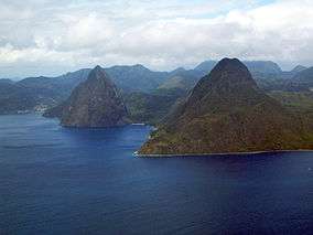 |
near Soufrière, 13°48′26″N 61°4′13″W / 13.80722°N 61.07028°W |
Natural: (vii), (viii) |
2,909 (7,190) | 2004 | [19] | |
| San Pedro de la Roca Castle, Santiago de Cuba | 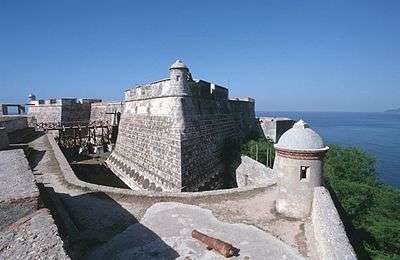 |
Santiago de Cuba Province, 19°58′0″N 75°52′15″W / 19.96667°N 75.87083°W |
Cultural: (iv), (v) |
— | 1997 | The large fort was built to defend the important port of Santiago de Cuba. The design of the fortification was based on Italian and Renaissance architecture. The complex of magazines, bastions, and batteries is one of the most complete and well-preserved Spanish-American defense fortifications. | [20] |
| Trinidad and the Valley de los Ingenios | _02.jpg) |
Sancti Spíritus Province, 21°48′11″N 79°59′4″W / 21.80306°N 79.98444°W |
Cultural: (iv), (v) |
— | 1988 | The city of Trinidad was founded in the early 16th century. In 1518, Hernán Cortés began his expedition to conquer Mexico from the port at Trinidad. The city prospered throughout the colonial period in large part due to the success of the local sugar industry. The adjacent Valley de los Ingenios was the origin of the Cuban sugar industry, which emerged in the 18th century. It is home to numerous cane sugar mills, as well as cattle ranches and tobacco plantations. | [21] |
| Urban Historic Centre of Cienfuegos | 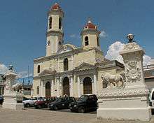 |
Cienfuegos, 22°8′50″N 80°27′10″W / 22.14722°N 80.45278°W |
Cultural: (ii), (v) |
— | 2005 | Cienfuegos was founded in 1819 as a Spanish colony, though its first inhabitants were French immigrants. It became a trade center in the sugar cane, tobacco, and coffee trade because of its location on the Bay of Cienfuegos. Because of its establishment in the later colonial period, the architecture has more modern influences: including modern ideas of urban planning. | [22] |
| Viñales Valley | 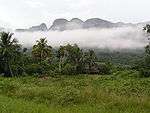 |
Pinar del Río Province, 22°37′N 83°43′W / 22.617°N 83.717°W |
Cultural: (iv) |
— | 1999 | The village of Viñales was founded in 1875 after the expansion of tobacco cultivation in the surrounding valley. The Valley features a karst topography, vernacular architecture, and traditional cultivation methods. The Valley was also the site of various military engagements in the Cuban War of Independence and Cuban Revolution. | [23] [24] |
Location of sites
Historic Town of St George and Related Fortifications, Bermuda site located off of map.
See also
Notes
References
- General
- "World Heritage Committee: 29th session" (PDF). UNESCO. Retrieved 26 June 2011.
- "World Heritage Committee: 30th session" (PDF). UNESCO. Retrieved 26 June 2011.
- "World Heritage Committee: 31st session" (PDF). UNESCO. Retrieved 26 June 2011.
- "World Heritage Committee: 33rd session" (PDF). UNESCO. Retrieved 26 June 2011.
- "World Heritage Committee: 34th session" (PDF). UNESCO. Retrieved 26 June 2011.
- Notes
- ↑ "World Heritage List". UNESCO. Retrieved 28 May 2010.
- ↑ "The Criteria for Selection". UNESCO. Retrieved 10 September 2011.
- ↑ "Alejandro de Humboldt National Park". UNESCO. Retrieved 28 May 2010.
- ↑ "Solenodon cubanus". International Union for Conservation of Nature. Retrieved November 12, 2010.
- 1 2 "Antigua Naval Dockyard and Related Archaeological Sites". UNESCO. Retrieved 28 April 2017.
- ↑ "Blue and John Crow Mountains". UNESCO. Retrieved 6 July 2015.
- ↑ "Brimstone Hill Fortress National Park". UNESCO. Retrieved 28 May 2010.
- ↑ "Colonial City of Santo Domingo". UNESCO. Retrieved 28 May 2010.
- ↑ "Desembarco del Granma National Park". UNESCO. Retrieved 28 May 2010.
- ↑ "In Depth: Dear Granma". Bayamo Travel Guide. Frommers. Retrieved November 12, 2010.
- ↑ "Historic Area of Willemstad, Inner City and Harbour, Curaçao". UNESCO. Retrieved 28 May 2010.
- ↑ "Historic Bridgetown and its Garrison". UNESCO. Retrieved 8 September 2011.
- ↑ "Historic Centre of Camagüey". UNESCO. Retrieved 28 May 2010.
- ↑ "Historic Town of St George and Related Fortifications, Bermuda". UNESCO. Retrieved 8 September 2011.
- ↑ "La Fortaleza and San Juan National Historic Site in Puerto Rico". UNESCO. Retrieved 28 July 2017.
- ↑ "Morne Trois Pitons National Park". UNESCO. Retrieved 28 May 2010.
- ↑ "National History Park – Citadel, Sans Souci, Ramiers". UNESCO. Retrieved 28 May 2010.
- ↑ "Old Havana and its Fortifications". UNESCO. Retrieved 28 May 2010.
- ↑ "Pitons Management Area". UNESCO. Retrieved 28 May 2010.
- ↑ "San Pedro de la Roca Castle, Santiago de Cuba". UNESCO. Retrieved 28 May 2010.
- ↑ "Trinidad and the Valley de los Ingenios". UNESCO. Retrieved 28 May 2010.
- ↑ "Urban Historic Centre of Cienfuegos". UNESCO. Retrieved 28 May 2010.
- ↑ "Viñales Valley". UNESCO. Retrieved 28 May 2010.
- ↑ "Viñales (Cuba)" (pdf). UNESCO. Retrieved October 22, 2010.
External links
- UNESCO World Heritage Centre official website
- UNESCO World Heritage List official website
- VRheritage.org – documentation of World Heritage sites
- Worldheritage-Forum – Information and weblog on World Heritage issues
| North America | ||
|---|---|---|
| Central America | ||
| The Caribbean |
| |
| South America | ||
This article is issued from
Wikipedia.
The text is licensed under Creative Commons - Attribution - Sharealike.
Additional terms may apply for the media files.