| Name |
Location |
Date Listed |
Grid Ref. [note 1] |
Geo-coordinates |
Notes |
HB Number [note 2] |
Image |
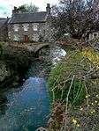
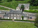
| Brownsbank Cottage |
Candy Mill, Elsrickle |
|
NT0749741856 |
55°39′41″N 3°28′19″W / 55.661379°N 3.471933°W / 55.661379; -3.471933 (Brownsbank Cottage) |
19th-century farm cottage, former home of poet Hugh MacDiarmid[5] |
640 |

|
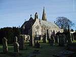
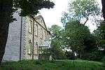
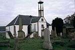
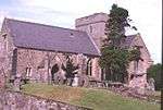
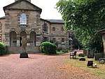
| Old Collegiate Church, St. Mary's Aisle, and Graveyard |
Carnwath, St Mary's Church |
|
NS9754246411 |
55°42′01″N 3°37′55″W / 55.70029°N 3.631806°W / 55.70029; -3.631806 (Old Collegiate Church, St. Mary's Aisle, and Graveyard) |
15th-century aisle of former church, located adjacent to present parish church[6] |
692 |
 Upload another image
|
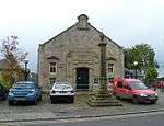
| Carnwath Cross |
Carnwath |
|
NS9792346401 |
55°42′01″N 3°37′33″W / 55.700281°N 3.625743°W / 55.700281; -3.625743 (Carnwath Cross) |
17th-century market cross[7] |
694 |
 Upload another image
|
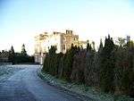
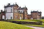
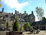
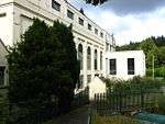
| Carstairs House (Monteith House) |
Carstairs |
|
NS9417644333 |
55°40′51″N 3°41′04″W / 55.680904°N 3.684535°W / 55.680904; -3.684535 (Carstairs House (Monteith House)) |
Tudor Gothic house by William Burn, 1823, later used as a hospital and nursing home[8] |
712 |
 Upload another image
|
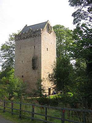
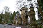
| Tower of Hallbar |
Crossford |
|
NS8393047130 |
55°42′13″N 3°50′55″W / 55.703679°N 3.848577°W / 55.703679; -3.848577 (Tower of Hallbar) |
16th-century tower house[9] |
723 |
 Upload another image
See more images
|
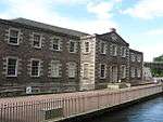
| High Mill |
Carluke, Chapel Street |
|
NS8493550778 |
55°44′12″N 3°50′03″W / 55.736679°N 3.834129°W / 55.736679; -3.834129 (High Mill) |
Late-18th-century windmill tower and 19th-century house, the most complete windmill in Scotland[10] |
726 |
 Upload another image
|
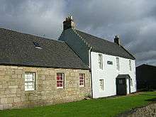
| Scots Mining Company House |
Leadhills |
|
NS8861614808 |
55°24′52″N 3°45′40″W / 55.414493°N 3.761013°W / 55.414493; -3.761013 (Scots Mining Company House) |
Early classical house built 1736, possibly by William Adam, for the manager of the lead mines[11] |
732 |
|
| Crossbasket |
East Kilbride |
|
NS6666856508 |
55°47′00″N 4°07′40″W / 55.783442°N 4.127646°W / 55.783442; -4.127646 (Crossbasket) |
16th-century tower with 19th-century house[12] |
1004 |
 Upload another image
|
| The Peel |
Busby |
|
NS5931356121 |
55°46′40″N 4°14′41″W / 55.777883°N 4.244629°W / 55.777883; -4.244629 (The Peel) |
16th-century tower with later additions[13] |
1005 |
.jpg) Upload another image
|
| The Peel, stable or barn |
Busby |
|
NS5936056067 |
55°46′39″N 4°14′38″W / 55.777412°N 4.243852°W / 55.777412; -4.243852 (The Peel, stable or barn) |
17th-century stable building[14] |
1006 |
|
| Wester Kittochside Farm |
East Kilbride |
|
NS6083256331 |
55°46′49″N 4°13′14″W / 55.780208°N 4.220538°W / 55.780208; -4.220538 (Wester Kittochside Farm) |
18th-century farm, gifted to the National Trust for Scotland in 1992, now part of the National Museum of Rural Life[15] |
1008 |
 Upload another image
|
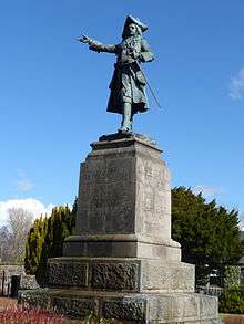
| Earl of Angus' Monument |
Douglas |
|
NS8346730955 |
55°33′30″N 3°50′57″W / 55.558308°N 3.849084°W / 55.558308; -3.849084 (Earl of Angus' Monument) |
Monument to James Douglas, Earl of Angus, sculpted by Thomas Brock, erected 1892[16] |
1457 |
 Upload another image
|
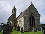
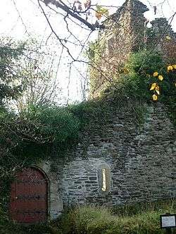
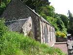
| St Bride's Chapel |
Douglas |
|
NS8358730952 |
55°33′30″N 3°50′50″W / 55.55831°N 3.847181°W / 55.55831; -3.847181 (St Bride's Chapel) |
Choir and south aisle of late-14th-century Gothic church, restored in 1878 by Robert Rowand Anderson, containing tombs of some of the Earls of Douglas[17] |
1490 |
 Upload another image
See more images
|
| Newbigging Market Cross |
Newbigging |
|
NT0151845916 |
55°41′48″N 3°34′06″W / 55.696669°N 3.568392°W / 55.696669; -3.568392 (Newbigging Market Cross) |
Market cross dated 1693[18] |
5093 |
|
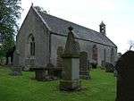
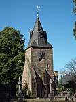
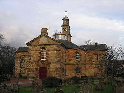
| Covington Parish Church |
Covington, Thankerton |
|
NS9750639751 |
55°38′26″N 3°37′48″W / 55.640466°N 3.629889°W / 55.640466; -3.629889 (Covington Parish Church) |
15th-century church, renovated 1903[19] |
5094 |
 Upload another image
|
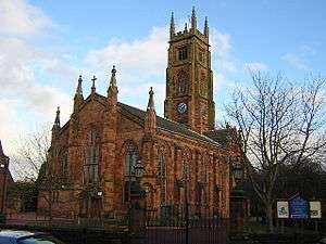
| Bothwell Parish Church (St Bride's Collegiate Church) |
Bothwell |
|
NS7049058604 |
55°48′12″N 4°04′04″W / 55.803302°N 4.067744°W / 55.803302; -4.067744 (Bothwell Parish Church (St Bride's Collegiate Church)) |
14th-century choir, extended by David Hamilton, 1833, restored 1898 by Robert Rowand Anderson[20] |
5134 |
 Upload another image
|
| Bothwell Parish Church, Joanna Baillie Monument |
Bothwell |
|
NS7044458591 |
55°48′11″N 4°04′06″W / 55.803173°N 4.068471°W / 55.803173; -4.068471 (Bothwell Parish Church, Joanna Baillie Monument) |
Italianate Doultonware monument to poet Joanna Baillie[21] |
5135 |
|
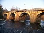
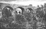
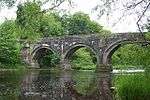
| Bothwell Bridge |
Bothwell, over the River Clyde |
|
NS7107757765 |
55°47′45″N 4°03′29″W / 55.795925°N 4.057988°W / 55.795925; -4.057988 (Bothwell Bridge) |
Earlier 17th-century four-arch bridge, altered in the 19th century, on site of the Battle of Bothwell Bridge, 1679[22] |
5138 |
 Upload another image
See more images
|
| Criagievar and Gleneden |
Bothwell, Laighlands Road |
|
NS7091158497 |
55°48′09″N 4°03′40″W / 55.802454°N 4.060982°W / 55.802454; -4.060982 (Criagievar and Gleneden) |
1855 villa by Alexander Thomson[23] |
5151 |
|
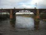
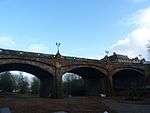
| Uddingston Viaduct |
Uddingston |
|
NS6879560883 |
55°49′24″N 4°05′45″W / 55.823307°N 4.095866°W / 55.823307; -4.095866 (Uddingston Viaduct) |
Three-arch cast-iron railway viaduct over River Clyde, 1848[24] |
5153 |
 Upload another image
|
| Scottish National Memorial to David Livingstone |
Blantyre, Station Road, David Livingstone Memorial |
|
NS6950858517 |
55°48′08″N 4°05′00″W / 55.802256°N 4.083357°W / 55.802256; -4.083357 (Scottish National Memorial to David Livingstone) |
18th-century workers' houses, now the David Livingstone Centre[25] |
5162 |
 Upload another image
See more images
|
| Dalserf Parish Church |
Dalserf |
|
NS7997950712 |
55°44′06″N 3°54′47″W / 55.734883°N 3.912982°W / 55.734883; -3.912982 (Dalserf Parish Church) |
17th- and 18th-century T-plan church with later alterations[26] |
5170 |
 Upload another image
See more images
|
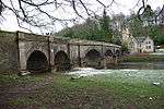
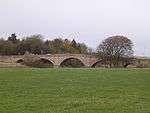
| Mauldslie Bridge |
Dalserf |
|
NS8036050245 |
55°43′51″N 3°54′24″W / 55.730784°N 3.906714°W / 55.730784; -3.906714 (Mauldslie Bridge) |
Three-arch stone bridge over the River Clyde by David Bryce, 1861, as private access to Mauldslie Castle (demolished)[27] |
5175 |
 Upload another image
|
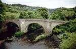
| Canderside Bridge |
Canderside, Stonehouse |
|
NS7654747435 |
55°42′17″N 3°57′58″W / 55.704594°N 3.966124°W / 55.704594; -3.966124 (Canderside Bridge) |
Three-arch stone bridge over Cander Water, by Thomas Telford, 1821[28] |
6452 |
 Upload another image
|
| Corehouse |
Falls of Clyde |
|
NS8822741580 |
55°39′17″N 3°46′41″W / 55.654846°N 3.777973°W / 55.654846; -3.777973 (Corehouse) |
Tudor Revival country house by Edward Blore, 1824–1827[29] |
7679 |
 Upload another image
See more images
|
| Corra Castle |
Falls of Clyde |
12/01/1971 |
NS8822941410 |
55°39′12″N 3°46′40″W / 55.653319°N 3.777872°W / 55.653319; -3.777872 (Corra Castle) |
Ruined tower[30] |
7680 |
 Upload another image
See more images
|
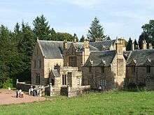
| Chatelherault Hunting Lodge and Leopard House |
Chatelherault Country Park, Hamilton |
|
NS7364453930 |
55°45′44″N 4°00′55″W / 55.762168°N 4.015293°W / 55.762168; -4.015293 (Chatelherault Hunting Lodge and Leopard House) |
Ornamental hunting lodge by William Adam, 1731, associated with Hamilton Palace [31] |
12485 |
 Upload another image
See more images
|
| Avon Bridge |
Hamilton, Carlisle Road |
|
NS7351054768 |
55°46′11″N 4°01′04″W / 55.769657°N 4.017816°W / 55.769657; -4.017816 (Avon Bridge) |
Single-span bridge by Thomas Telford, 1820, carrying the A72 road over the Avon Water[32] |
12516 |
.jpg) Upload another image
|
| Old Avon Bridge |
Hamilton, Old Avon Road |
|
NS7332254637 |
55°46′06″N 4°01′15″W / 55.768432°N 4.020749°W / 55.768432; -4.020749 (Old Avon Bridge) |
17th-century three-arch bridge over the Avon Water[33] |
12518 |
 Upload another image
|
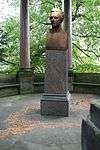
| Hamilton Monument |
Hamilton |
|
NS7289854385 |
55°45′58″N 4°01′39″W / 55.766058°N 4.027385°W / 55.766058; -4.027385 (Hamilton Monument) |
Bust of William Hamilton, 11th Duke of Hamilton by T. Mossmann, dated 1869[34] |
12520 |
 Upload another image
|
| Barncluith House, terraces and summerhouse |
Hamilton |
|
NS7299554480 |
55°46′01″N 4°01′33″W / 55.766936°N 4.025885°W / 55.766936; -4.025885 (Barncluith House, terraces and summerhouse) |
16th-century garden terraces[35] |
12522 |
_(14760846574).jpg) Upload another image
|
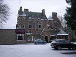
| Baronald (Cartland Bridge Hotel) |
Lanark |
|
NS8734844615 |
55°40′55″N 3°47′35″W / 55.681899°N 3.793182°W / 55.681899; -3.793182 (Baronald (Cartland Bridge Hotel)) |
Large Scots Baronial mansion by Sir John James Burnet, 1891[36] |
12967 |
 Upload another image
|
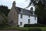
| Jerviswood |
Lanark |
|
NS8837645514 |
55°41′25″N 3°46′38″W / 55.69021°N 3.777208°W / 55.69021; -3.777208 (Jerviswood) |
17th-century house[37] |
13053 |
|
| Hyndford Bridge |
Lanark |
|
NS9147941460 |
55°39′16″N 3°43′35″W / 55.654506°N 3.726268°W / 55.654506; -3.726268 (Hyndford Bridge) |
Five-arch bridge of 1773, carrying the A73 road over the River Clyde[38] |
13055 |
 Upload another image
|
| Corra Linn, Bonnington Pavilion |
Falls of Clyde |
|
NS8848641473 |
55°39′14″N 3°46′26″W / 55.653944°N 3.773816°W / 55.653944; -3.773816 (Corra Linn, Bonnington Pavilion) |
18th-century classical viewing pavilion[39] |
13065 |
 Upload another image
See more images
|
| Symington House |
Symington |
|
NT0097335192 |
55°36′01″N 3°34′23″W / 55.600237°N 3.573191°W / 55.600237; -3.573191 (Symington House) |
Neo-Georgian mansion of 1915 by Andrew Prentice[40] |
19673 |
.jpg) Upload another image
|
| Gas Showrooms |
Biggar, Gasworks Road |
|
NT0389137707 |
55°37′24″N 3°31′40″W / 55.623412°N 3.527777°W / 55.623412; -3.527777 (Gas Showrooms) |
Showrooms of circa 1840[41] |
22170 |
 Upload another image
|
| Gaswork Manager's House |
Biggar, Gasworks Road |
|
NT0391337699 |
55°37′24″N 3°31′39″W / 55.623345°N 3.527425°W / 55.623345; -3.527425 (Gaswork Manager's House) |
House of circa 1840[42] |
22171 |
|
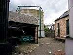
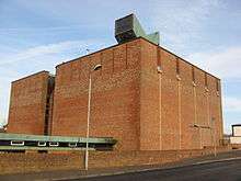
| Biggar Gasworks |
Biggar |
|
NT0388037687 |
55°37′24″N 3°31′41″W / 55.62323°N 3.527945°W / 55.62323; -3.527945 (Biggar Gasworks) |
Important early gaswork with many original features, 1839 onwards[43] |
22172 |
 Upload another image
See more images
|
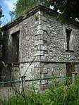
| Cadger's Brig |
Biggar |
|
NT0387537615 |
55°37′21″N 3°31′41″W / 55.622583°N 3.527999°W / 55.622583; -3.527999 (Cadger's Brig) |
18th-century single-arch bridge[44] |
22173 |
 Upload another image
|
| St Mary's Church |
Biggar |
|
NS0404737895 |
55°37′30″N 3°31′31″W / 55.6251°N 3.5254°W / 55.6251; -3.5254 (St Mary's Church) |
16th-century church [45] |
22257 |
 Upload another image
|
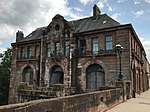
| The Hunter Museum (formerly Hunter House) |
East Kilbride, Maxwelton Road |
|
NS6522255804 |
55°46′36″N 4°09′01″W / 55.77672°N 4.150337°W / 55.77672; -4.150337 (The Hunter Museum (formerly Hunter House)) |
18th-century house, converted to museum 1996[46] |
26607 |
 Upload another image
|
| Brousterlands |
East Kilbride, Brousterhill |
|
NS6345154407 |
55°45′49″N 4°10′40″W / 55.76368°N 4.17785°W / 55.76368; -4.17785 (Brousterlands) |
Late-17th-century classical laird's house[47] |
26619 |
 Upload another image
|
| Mains Castle |
East Kilbride |
|
NS6278856041 |
55°46′41″N 4°11′21″W / 55.778163°N 4.18923°W / 55.778163; -4.18923 (Mains Castle) |
Mid 15th-century tower house, restored in the 1970s[48] |
26626 |
 Upload another image
See more images
|
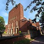
| St Bride's Roman Catholic Church |
East Kilbride |
|
NS6404754304 |
55°45′47″N 4°10′06″W / 55.762923°N 4.168307°W / 55.762923; -4.168307 (St Bride's Roman Catholic Church) |
1964 church by Gillespie, Kidd and Coia[49] |
26630 |
 Upload another image
See more images
|
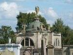
| Rutherglen Tower and fragments of Old Church |
Rutherglen |
|
NS6133161705 |
55°49′43″N 4°12′55″W / 55.8286°N 4.215328°W / 55.8286; -4.215328 (Rutherglen Tower and fragments of Old Church) |
Late medieval with later rebuilding[50] |
33563 |
 Upload another image
|
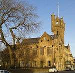
| Rutherglen Town Hall |
Rutherglen |
|
NS6137561700 |
55°49′43″N 4°12′53″W / 55.828568°N 4.214624°W / 55.828568; -4.214624 (Rutherglen Town Hall) |
Scots baronial town hall by Charles Wilson, 1862[51] |
33564 |
 Upload another image
See more images
|
| St Columbkille's Roman Catholic Church |
Rutherglen |
|
NS6142261590 |
55°49′39″N 4°12′50″W / 55.827594°N 4.213818°W / 55.827594; -4.213818 (St Columbkille's Roman Catholic Church) |
Church by Gillespie, Kidd and Coia, 1934–40[52] |
33567 |
 Upload another image
|
| Sheriff Court Buildings |
Hamilton, Almada Street |
|
NS7160055907 |
55°46′46″N 4°02′56″W / 55.779381°N 4.048776°W / 55.779381; -4.048776 (Sheriff Court Buildings) |
Mid 19th-century classical buildings[53] |
34470 |
 Upload another image
|
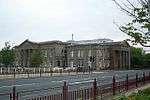
| Lanark County Buildings (South Lanarkshire Council Headquarters) |
Hamilton, Almada Street |
|
NS7147155882 |
55°46′45″N 4°03′03″W / 55.779122°N 4.050819°W / 55.779122; -4.050819 (Lanark County Buildings (South Lanarkshire Council Headquarters)) |
International modern tower by D G Bannerman, 1959–64[54] |
34472 |
 Upload another image
|
| Hamilton Old Parish Church |
Hamilton |
|
NS7232755534 |
55°46′34″N 4°02′13″W / 55.776225°N 4.037018°W / 55.776225; -4.037018 (Hamilton Old Parish Church) |
Church by William Adam, 1732[55] |
34473 |
 Upload another image
|
| Hamilton Old Parish Church, churchyard |
Hamilton |
|
NS7234255555 |
55°46′35″N 4°02′12″W / 55.776417°N 4.036789°W / 55.776417; -4.036789 (Hamilton Old Parish Church, churchyard) |
17th- and 18th-century monuments, and medieval Netherton Cross[56] |
34474 |
 Upload another image
|
| 92-94 Cadzow Street |
Hamilton |
|
NS7233255638 |
55°46′38″N 4°02′13″W / 55.77716°N 4.036987°W / 55.77716; -4.036987 (92-94 Cadzow Street) |
Large commercial building built along with Cadzow bridge, by Babtie & Bonn, structural engineers, 1903[57] |
34503 |
 Upload another image
|
| Cadzow Bridge, Cadzow Street |
Hamilton |
|
NS7230055630 |
55°46′37″N 4°02′15″W / 55.777079°N 4.037493°W / 55.777079; -4.037493 (Cadzow Bridge, Cadzow Street) |
19th-century bridge widened in 1903 by Babtie & Bonn[58] |
34504 |
 Upload another image
|
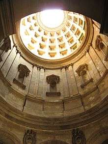
| Hamilton Mausoleum |
Hamilton |
|
NS7269056316 |
55°47′00″N 4°01′54″W / 55.783342°N 4.0316°W / 55.783342; -4.0316 (Hamilton Mausoleum) |
Roman style mausoleum of Alexander, 10th Duke of Hamilton, built 1855 by David Bryce[59] |
34518 |
 Upload another image
See more images
|
| Hamilton Burgh Museum |
Hamilton, Muir Street |
|
NS7244355899 |
55°46′46″N 4°02′07″W / 55.779533°N 4.035341°W / 55.779533; -4.035341 (Hamilton Burgh Museum) |
18th-century house by James Smith and later assembly rooms, now part of the Low Parks Museum[60] |
34521 |
 Upload another image
|
| Riding School |
Hamilton, Muir Street |
Not listed |
NS7245455923 |
55°46′47″N 4°02′07″W / 55.779751°N 4.035177°W / 55.779751; -4.035177 (Riding School) |
19th-century building, now part of the Low Parks Museum[61] |
34522 |
|
| Gates, gatepiers and railings at Auction Room and Cattle Market |
Lanark, Hyndford Road |
|
NS8890043200 |
55°40′10″N 3°46′05″W / 55.669549°N 3.767939°W / 55.669549; -3.767939 (Gates, gatepiers and railings at Auction Room and Cattle Market) |
Pair of wrought- and cast-iron former toll gates, circa 1820 [62] |
37024 |
|
| Cemetery Chapel |
Lanark, Hyndford Road |
7/5/1980 |
NS8887543193 |
55°40′10″N 3°46′06″W / 55.669481°N 3.768333°W / 55.669481; -3.768333 (Cemetery Chapel) |
[63] |
37029 |
 Upload another image
|
| Clydesholm Bridge |
Lanark, Mousemill Road |
|
NS8687243918 |
55°40′32″N 3°48′02″W / 55.675529°N 3.80046°W / 55.675529; -3.80046 (Clydesholm Bridge) |
3-span bridge built by John Lockhart of Birkenhead, 1696–99, the oldest surviving crossing of the River Clyde[64] |
37032 |
 Upload another image
|
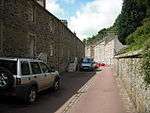
| New Lanark, Community Hall (former church) |
New Lanark |
|
NS8801442650 |
55°39′52″N 3°46′54″W / 55.664406°N 3.781793°W / 55.664406; -3.781793 (New Lanark, Community Hall (former church)) |
Simple Gothic church by Thomas Carlaw, 1899[65] |
37037 |
 Upload another image
|
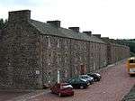
| New Lanark, 1-10 (inclusive) Braxfield Row |
New Lanark |
|
NS8788742713 |
55°39′54″N 3°47′02″W / 55.664942°N 3.783837°W / 55.664942; -3.783837 (New Lanark, 1-10 (inclusive) Braxfield Row) |
Gabled terrace of mill workers' houses, circa 1790 [66] |
37038 |
|
| New Lanark, 1-8 (inclusive) Caithness Row and the Counting House |
New Lanark |
|
NS8813042492 |
55°39′47″N 3°46′48″W / 55.663014°N 3.779886°W / 55.663014; -3.779886 (New Lanark, 1-8 (inclusive) Caithness Row and the Counting House) |
Gabled terrace of mill workers' houses, circa 1790, with Counting House of 1816, restored 1966 [67] |
37039 |
 Upload another image
|
| New Lanark, 9-16 (inclusive) Caithness Row with garages (former abattoir) |
New Lanark |
|
NS8815842445 |
55°39′45″N 3°46′46″W / 55.662598°N 3.779422°W / 55.662598; -3.779422 (New Lanark, 9-16 (inclusive) Caithness Row with garages (former abattoir)) |
Gabled terrace of mill workers' houses, circa 1790, restored 1966[68] |
37040 |
|
| New Lanark, 1-8 (inclusive) Double Row, known as Wee Row |
New Lanark |
|
NS8796242626 |
55°39′51″N 3°46′57″W / 55.664178°N 3.78261°W / 55.664178; -3.78261 (New Lanark, 1-8 (inclusive) Double Row, known as Wee Row) |
Late-18th-century terrace of mill workers' houses, restored 1994[69] |
37041 |
 Upload another image
|
| New Lanark, 9-24 (inclusive) Double Row |
New Lanark |
|
NS8791142650 |
55°39′52″N 3°47′00″W / 55.664382°N 3.78343°W / 55.664382; -3.78343 (New Lanark, 9-24 (inclusive) Double Row) |
Late-18th-century gabled terrace of mill workers' houses[70] |
37042 |
 Upload another image
|
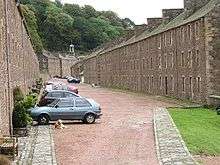
| New Lanark, 1-14 (inclusive) Long Row |
New Lanark |
|
NS8793542661 |
55°39′52″N 3°46′59″W / 55.664487°N 3.783053°W / 55.664487; -3.783053 (New Lanark, 1-14 (inclusive) Long Row) |
Late-18th-century terrace of mill workers' houses, the longest terrace at New Lanark[71] |
37043 |
Upload another image
|
| New Lanark, New Buildings |
New Lanark |
|
NS8809342562 |
55°39′49″N 3°46′50″W / 55.663634°N 3.780502°W / 55.663634; -3.780502 (New Lanark, New Buildings) |
Classical Palazzo-style gabled terrace of mill workers' tenements, 1798, restored from 1978[72] |
37045 |
 Upload another image
|
| New Lanark, 1-11 (inclusive) Nursery Buildings |
New Lanark |
|
NS8810442552 |
55°39′49″N 3°46′49″W / 55.663547°N 3.780323°W / 55.663547; -3.780323 (New Lanark, 1-11 (inclusive) Nursery Buildings) |
Terrace of mill workers' tenements with village bakery, 1809 with 1850 additions[73] |
37046 |
.jpg) Upload another image
|
| New Lanark, 1 and 3 Rosedale Street, Robert Owen's House |
New Lanark |
|
NS8802542594 |
55°39′50″N 3°46′54″W / 55.663906°N 3.781596°W / 55.663906; -3.781596 (New Lanark, 1 and 3 Rosedale Street, Robert Owen's House) |
Gabled house of circa 1790[74] |
37047 |
 Upload another image
|
| New Lanark, 5 and 7 Rosedale Street, David Dale's House |
New Lanark |
|
NS8799242611 |
55°39′51″N 3°46′56″W / 55.664051°N 3.782127°W / 55.664051; -3.782127 (New Lanark, 5 and 7 Rosedale Street, David Dale's House) |
Gabled house of circa 1790[75] |
37048 |
 Upload another image
|
| New Lanark, Visitor Centre (formerly New Institution For The Formation Of Character and Engine House) |
New Lanark |
|
NS8807742504 |
55°39′47″N 3°46′51″W / 55.663109°N 3.780733°W / 55.663109; -3.780733 (New Lanark, Visitor Centre (formerly New Institution For The Formation Of Character and Engine House)) |
Classical former Institution of 1816, engine house added to north in 1881[76] |
37049 |
 Upload another image
|
| New Lanark, Education Centre (formerly the School) |
New Lanark |
|
NS8810442432 |
55°39′45″N 3°46′49″W / 55.662469°N 3.780274°W / 55.662469; -3.780274 (New Lanark, Education Centre (formerly the School)) |
Symmetrical classical former school, 1817[77] |
37050 |
 Upload another image
|
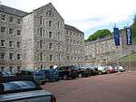
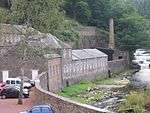
| New Lanark, Mill No 1 |
New Lanark |
|
NS8795042556 |
55°39′49″N 3°46′58″W / 55.663547°N 3.782772°W / 55.663547; -3.782772 (New Lanark, Mill No 1) |
5-storey mill, built 1786, rebuilt after fire 1789, restored as a hotel in the 1990s[78] |
37051 |
 Upload another image
|
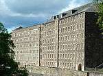
| New Lanark, Mill No 2 |
New Lanark |
|
NS8798242532 |
55°39′48″N 3°46′56″W / 55.663339°N 3.782253°W / 55.663339; -3.782253 (New Lanark, Mill No 2) |
5-storey textile mill, built circa 1789 and linked to Mill No 1 by 1817, extended north in 1885[79] |
37052 |
 Upload another image
|
| New Lanark, Mill No 3 with Turbine House |
New Lanark |
|
NS8800942516 |
55°39′48″N 3°46′55″W / 55.663201°N 3.781818°W / 55.663201; -3.781818 (New Lanark, Mill No 3 with Turbine House) |
6-storey classical textile mill, built 1833, the best-preserved of the New Lanark mills[80] |
37053 |
Upload another image
|
| New Lanark, Mechanics' Workshop |
New Lanark |
|
NS8811542353 |
55°39′42″N 3°46′48″W / 55.661762°N 3.780067°W / 55.661762; -3.780067 (New Lanark, Mechanics' Workshop) |
2-storey classical block of 1806[81] |
37054 |
 Upload another image
|
| New Lanark, Scottish Wildlife Trust Visitor Centre (formerly dyeworks and foundry) |
New Lanark |
|
NS8809642347 |
55°39′42″N 3°46′49″W / 55.661704°N 3.780367°W / 55.661704; -3.780367 (New Lanark, Scottish Wildlife Trust Visitor Centre (formerly dyeworks and foundry)) |
Former foundry, 1806[82] |
37055 |
 Upload another image
|
| New Lanark, Retort House Chimney |
New Lanark |
|
NS8809042282 |
55°39′40″N 3°46′50″W / 55.661119°N 3.780436°W / 55.661119; -3.780436 (New Lanark, Retort House Chimney) |
Octagonal sandstone chimney of earlier 19th-century gas-making plant[83] |
37056 |
 Upload another image
|
| St Mary's Roman Catholic Church |
Lanark, St Vincent Place |
|
NS8857043510 |
55°40′20″N 3°46′24″W / 55.672258°N 3.773309°W / 55.672258; -3.773309 (St Mary's Roman Catholic Church) |
Mid 19th-century Gothic revival church by Goldie and Hadfield, rebuilt 1908 after fire[84] |
37062 |
.jpg) Upload another image
|
| St Mary's Church Hall |
Lanark, St Vincent Place |
|
NS8856043549 |
55°40′21″N 3°46′25″W / 55.672605°N 3.773483°W / 55.672605; -3.773483 (St Mary's Church Hall) |
Mid 19th-century school by Goldie and Hadfield[85] |
37065 |
|
| St Mary's Presbytery |
Lanark, St Vincent Place |
|
NS8859943511 |
55°40′20″N 3°46′22″W / 55.672273°N 3.772848°W / 55.672273; -3.772848 (St Mary's Presbytery) |
Mid 19th-century L-plan building by Goldie and Hadfield[86] |
37066 |
|
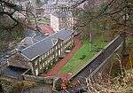
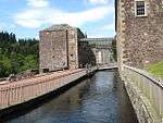
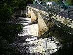
| New Lanark, Weir, Tunnel and Lade |
New Lanark |
|
NS8811642077 |
55°39′33″N 3°46′48″W / 55.659284°N 3.779939°W / 55.659284; -3.779939 (New Lanark, Weir, Tunnel and Lade) |
Stone and timber weir and rock-cut tunnel, built 1785[87] |
44552 |
 Upload another image
|
| Mauldslie West Lodge, gateway and gates |
Mauldslie, Dalserf |
|
NS8032850238 |
55°43′51″N 3°54′26″W / 55.730713°N 3.90722°W / 55.730713; -3.90722 (Mauldslie West Lodge, gateway and gates) |
Gothic lodge, probably David Bryce, dated 1861[88] |
45125 |
 Upload another image
|
| New Lanark, Water Houses |
New Lanark |
|
NS8793842530 |
55°39′48″N 3°46′59″W / 55.663311°N 3.782952°W / 55.663311; -3.782952 (New Lanark, Water Houses) |
Terrace of former stores, built 1810 and converted to residential use in the 1990s[89] |
46471 |
|
| Torrance House |
Calderglen Country Park, East Kilbride |
|
NS6547852651 |
55°44′55″N 4°08′41″W / 55.748482°N 4.144704°W / 55.748482; -4.144704 (Torrance House) |
Early-17th-century L-plan tower house, with 18th-century additions to designs by William Adam, and 19th-century Scots Baronial alterations[90] |
48654 |
 Upload another image
|
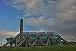
| Dollan Aqua Centre |
East Kilbride |
13 June 2002 |
NS6316054220 |
55°45′43″N 4°10′57″W / 55.761919°N 4.18239°W / 55.761919; -4.18239 (Dollan Aqua Centre) |
Swimming pool by Buchanan Campbell, 1965, with parabolic roof[91] |
48682 |
 Upload another image
See more images
|
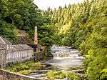
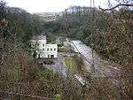
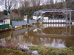
| Stonebyres Power Station |
Falls of Clyde |
11/02/2011 |
NS8502044158 |
55°40′38″N 3°49′43″W / 55.677249°N 3.828663°W / 55.677249; -3.828663 (Stonebyres Power Station) |
Hydro-electric plant [92] |
51719 |
 Upload another image
|
| Stonebyres Power Station wier and bridge |
Falls of Clyde |
11/02/2011 |
NS8550744025 |
55°40′34″N 3°49′20″W / 55.676170°N 3.822198°W / 55.676170; -3.822198 (Stonebyres Power Station wier and bridge) |
[93] |
51720 |
 Upload another image
|
| Bonnington Power Station |
Falls of Clyde |
3/3/2011 |
NS8839841665 |
55°39′20″N 3°46′31″W / 55.655649°N 3.775292°W / 55.655649; -3.775292 (Bonnington Power Station) |
Hydro-electric plant[94] |
51727 |
 Upload another image
|
| Bonnington Power Station wier and bridge |
Falls of Clyde |
3/3/2011 |
NS8550744025 |
55°40′34″N 3°49′20″W / 55.676170°N 3.822198°W / 55.676170; -3.822198 (Bonnington Power Station wier and bridge) |
[95] |
51728 |
 Upload another image
|