| Name |
Location |
Date Listed |
Grid Ref. [note 1] |
Geo-coordinates |
Notes |
HB Number [note 2] |
Image |
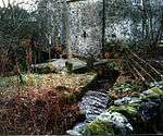
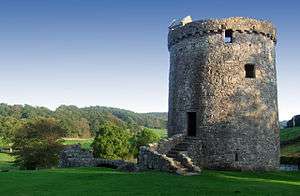
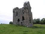
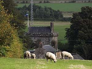
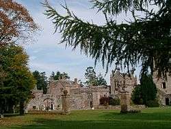
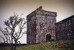
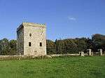
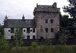
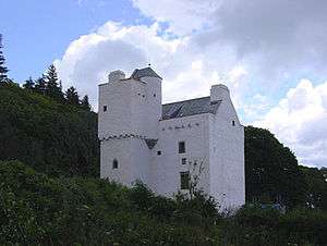
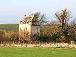
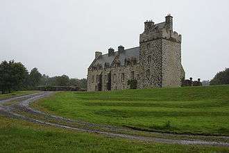
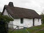
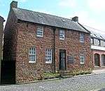
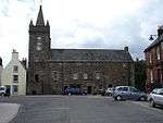
| Rusco Tower |
Gatehouse of Fleet |
|
NX5842060419 |
54°55′06″N 4°12′38″W / 54.918333°N 4.210441°W / 54.918333; -4.210441 (Rusco Tower) |
Early-16th-century tower house[5] |
3299 |
 Upload another image
See more images
|
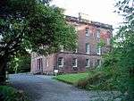
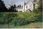
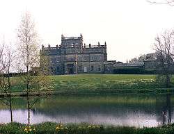
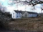
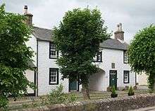
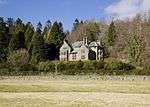
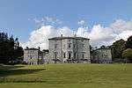
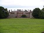
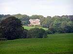
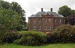
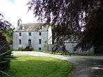
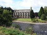
| Ardwall House |
Anwoth |
|
NX5813454737 |
54°52′02″N 4°12′44″W / 54.86723°N 4.2121°W / 54.86723; -4.2121 (Ardwall House) |
18th-century country house[6] |
3302 |

|
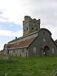
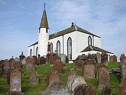
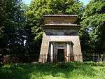
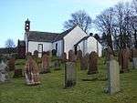
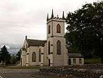
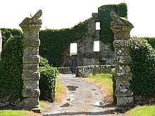
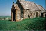
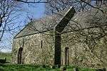
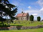
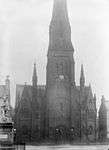
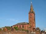
| Anwoth Old Church, Gordon Tomb and Churchyard |
Anwoth |
|
NX5827356209 |
54°52′50″N 4°12′38″W / 54.880487°N 4.21066°W / 54.880487; -4.21066 (Anwoth Old Church, Gordon Tomb and Churchyard) |
Ruins of 17th-century church, and early Renaissance monument to the Gordon family, circa 1620[7] |
3309 |
 Upload another image
See more images
|
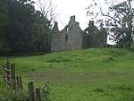
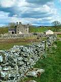
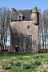
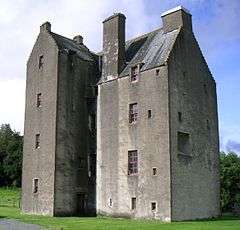
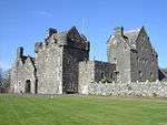
| Barscobe Castle |
Balmaclellan |
|
NX6596780640 |
55°06′07″N 4°06′08″W / 55.102004°N 4.102266°W / 55.102004; -4.102266 (Barscobe Castle) |
17th-century L-plan tower house, with later additions[8] |
3310 |
 Upload another image
See more images
|
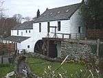
| Ironmacannie Mill |
Ironmacannie, Balmaclellan |
|
NX6672175330 |
55°03′16″N 4°05′17″W / 55.054523°N 4.087971°W / 55.054523; -4.087971 (Ironmacannie Mill) |
18th- and 19th-century grain mill, with much surviving machinery[9] |
3315 |
 Upload another image
|
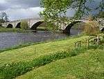
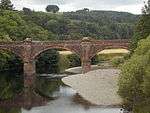
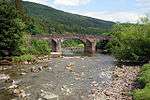
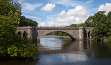
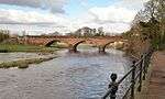
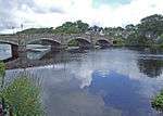
| Ken Bridge |
New Galloway, carrying the A712 over the Water of Ken |
|
NX6404878357 |
55°04′52″N 4°07′52″W / 55.08098°N 4.131229°W / 55.08098; -4.131229 (Ken Bridge) |
Five-arch granite bridge by John Rennie, 1821[10] |
3316 |
 Upload another image
|
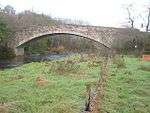
| Millhouse Bridge [note 3] |
Millhousebridge, over the River Annan |
|
NY1047185524 |
55°09′21″N 3°24′24″W / 55.155918°N 3.40658°W / 55.155918; -3.40658 (Millhouse Bridge [note 4]) |
30 metres (98 ft) single-span stone arch bridge[11][12] |
9954 3324, 9954 |
|
| Old Tollbar Cottage |
Dinwoodie, Johnstonebridge |
|
NY1043090151 |
55°11′51″N 3°24′31″W / 55.197475°N 3.408689°W / 55.197475; -3.408689 (Old Tollbar Cottage) |
Toll house of 1822 by Thomas Telford[13] |
3327 |
 Upload another image
|
| Jardine Hall Stable Block |
Millhousebridge |
|
NY1005387855 |
55°10′36″N 3°24′50″W / 55.176782°N 3.413878°W / 55.176782; -3.413878 (Jardine Hall Stable Block) |
Large quadrangular stable block of 1825, possibly by James Gillespie Graham; Jardine Hall demolished 1964 [14] |
3340 |
|
| Jardine Hall, Walled Garden and Gateways |
Millhousebridge |
|
NY0991587866 |
55°10′37″N 3°24′58″W / 55.176855°N 3.416048°W / 55.176855; -3.416048 (Jardine Hall, Walled Garden and Gateways) |
Gardens of circa 1820, possibly by James Gillespie Graham; Jardine Hall demolished 1964 [15] |
3341 |
|
| Buittle Bridge, (also known as Craignair Bridge) |
Dalbeattie, carrying the A711 over the Urr Water |
|
NX8224960655 |
54°55′36″N 3°50′20″W / 54.926645°N 3.838996°W / 54.926645; -3.838996 (Buittle Bridge, (also known as Craignair Bridge)) |
Single-arch stone bridge built 1797[16] |
3364 |
 Upload another image
|
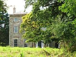
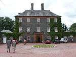
| Rammerscales House |
Hightae, Lochmaben |
|
NY0819577642 |
55°05′05″N 3°26′23″W / 55.084695°N 3.439736°W / 55.084695; -3.439736 (Rammerscales House) |
Palladian mansion of circa 1760[17] |
3378 |
 Upload another image
|
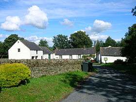
| Corseyard Farm |
Borgue |
|
NX5910148585 |
54°48′44″N 4°11′39″W / 54.812259°N 4.194044°W / 54.812259; -4.194044 (Corseyard Farm) |
Italianate model dairy steading, built 1914 with elaborate finishes[18] |
3381 |
 Upload another image
|
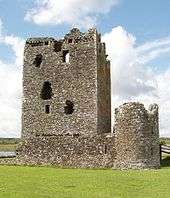
| Orchardton Tower |
Palnackie |
|
NX8169655126 |
54°52′37″N 3°50′43″W / 54.876854°N 3.845347°W / 54.876854; -3.845347 (Orchardton Tower) |
15th-century cylindrical tower, the only one known in Scotland[19] |
3387 |
 Upload another image
See more images
|
| Borgue Old House |
Borgue |
|
NX6334348209 |
54°48′36″N 4°07′40″W / 54.810058°N 4.127909°W / 54.810058; -4.127909 (Borgue Old House) |
Roofless house of 17th century[20] |
3393 |
 Upload another image
See more images
|
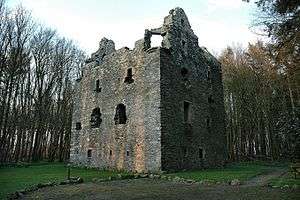
| Plunton Castle |
Borgue |
|
NX6049550736 |
54°49′55″N 4°10′24″W / 54.831965°N 4.173407°W / 54.831965; -4.173407 (Plunton Castle) |
Roofless mid-16th-century L-plan tower house[21] |
3403 |
 Upload another image
See more images
|
| Threave Castle |
Castle Douglas, on an island in the River Dee |
|
NX7392062281 |
54°56′21″N 3°58′11″W / 54.939212°N 3.969598°W / 54.939212; -3.969598 (Threave Castle) |
Later 14th-century stronghold of the Black Douglases[22] |
3408 |
 Upload another image
See more images
|
| Hensol House |
Parton |
|
NX6756069835 |
55°00′19″N 4°04′20″W / 55.005401°N 4.072297°W / 55.005401; -4.072297 (Hensol House) |
Country house of 1822 by Robert Lugar[23] |
3415 |
 Upload another image
|
| Hensol House, The Lainshaw Sundial |
Parton |
|
NX6758469806 |
55°00′19″N 4°04′19″W / 55.005147°N 4.071909°W / 55.005147; -4.071909 (Hensol House, The Lainshaw Sundial) |
Later 17th-century sundial, moved here from Lainshaw estate in Ayrshire[24] |
3416 |
Upload another image
|
| Shillahill Bridge |
Carries the A709 over the River Annan between Lochmaben and Lockerbie |
|
NY1061980703 |
55°06′45″N 3°24′10″W / 55.112636°N 3.402738°W / 55.112636; -3.402738 (Shillahill Bridge) |
Mid-19th-century five-arch bridge[25] |
3453 |
 Upload another image
|
| Dalton Old Parish Churchyard |
Dalton |
|
NY1143073979 |
55°03′09″N 3°23′17″W / 55.052378°N 3.387934°W / 55.052378; -3.387934 (Dalton Old Parish Churchyard) |
Walled churchyard with 18th-20th century tombstones and monuments[26] |
3455 |
.jpg) Upload another image
|
| Denbie House |
Dalton |
|
NY1110172955 |
55°02′35″N 3°23′34″W / 55.04312°N 3.392763°W / 55.04312; -3.392763 (Denbie House) |
Early-19th-century country house[27] |
3469 |
|
| Denbie, Dovecot |
Dalton |
|
NY1089773062 |
55°02′39″N 3°23′46″W / 55.044044°N 3.395988°W / 55.044044; -3.395988 (Denbie, Dovecot) |
Octagonal dovecote dated 1775[28] |
3470 |
|
| Bonshaw Tower and House |
Kirtlebridge |
|
NY2425672068 |
55°02′14″N 3°11′12″W / 55.037332°N 3.186711°W / 55.037332; -3.186711 (Bonshaw Tower and House) |
Mid-16th-century tower house with 1770 country house and later additions[29] |
3489 |
 Upload another image
See more images
|
| Brydekirk Bridge |
Brydekirk over the River Annan |
|
NY1865970549 |
55°01′22″N 3°16′26″W / 55.0228°N 3.273832°W / 55.0228; -3.273832 (Brydekirk Bridge) |
Three-arch road bridge of 1817[30] |
3494 |
 Upload another image
|
| Gilnockie Bridge |
Hollows, Canonbie, over the River Esk |
|
NY3857878172 |
55°05′39″N 2°57′50″W / 55.094154°N 2.96397°W / 55.094154; -2.96397 (Gilnockie Bridge) |
Two-arch stone bridge built 1793[31] |
3504 |
.jpg) Upload another image
|
| Byreburnfoot Bridge and Embankment |
Hollows, Canonbie, over the Byre Burn |
|
NY3902277971 |
55°05′33″N 2°57′25″W / 55.092403°N 2.956971°W / 55.092403; -2.956971 (Byreburnfoot Bridge and Embankment) |
Single-span stone bridge of 1850[32] |
3520 |
|
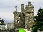
| Hollows or Gilnockie Tower |
Hollows, Canonbie |
|
NY3823178559 |
55°05′51″N 2°58′10″W / 55.097588°N 2.969491°W / 55.097588; -2.969491 (Hollows or Gilnockie Tower) |
16th-century tower house, restored in 1980; unusual beacon tower[33] |
3527 |
 Upload another image
See more images
|
| Cruck-framed building |
Priorslynn, Canonbie |
|
NY3936275836 |
55°04′24″N 2°57′04″W / 55.073262°N 2.951189°W / 55.073262; -2.951189 (Cruck-framed building) |
Later 18th-century clay-walled and cruck-framed agricultural building[34] |
3531 |
|
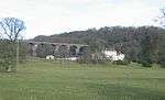
| Riddings Junction Viaduct [note 5] |
Rowanburn, over Liddel Water |
|
NY4108475634 |
55°04′18″N 2°55′27″W / 55.071655°N 2.924183°W / 55.071655; -2.924183 (Riddings Junction Viaduct [note 6]) |
Nine-arch railway viaduct built 1864, now disused[35] |
3533 |
 Upload another image
|
| Tarrasfoot Tile Works |
Tarrasfoot, Canonbie |
|
NY3806180952 |
55°07′09″N 2°58′22″W / 55.119067°N 2.972676°W / 55.119067; -2.972676 (Tarrasfoot Tile Works) |
19th- and early-20th-century tile works, now disused[36] |
3535 |
|
| Hoddom Castle |
Brydekirk |
|
NY1560972966 |
55°02′38″N 3°19′20″W / 55.044005°N 3.32224°W / 55.044005; -3.32224 (Hoddom Castle) |
16th-century tower house with 17th- and 19th-century additions[37] |
3558 |
 Upload another image
See more images
|
| Repentance Tower |
Hoddom Castle, Brydekirk |
|
NY1549672246 |
55°02′15″N 3°19′26″W / 55.037518°N 3.323794°W / 55.037518; -3.323794 (Repentance Tower) |
16th-century tower house[38] |
3570 |
 Upload another image
See more images
|
| Kinmount House |
Cummertrees |
|
NY1402568696 |
55°00′19″N 3°20′45″W / 55.005373°N 3.345735°W / 55.005373; -3.345735 (Kinmount House) |
Country house of 1820, by Robert Smirke[39] |
3582 |
 Upload another image
See more images
|
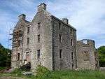
| Earlstoun Castle |
Earlstoun, St John's Town of Dalry |
|
NX6126884022 |
55°07′52″N 4°10′39″W / 55.13108°N 4.177508°W / 55.13108; -4.177508 (Earlstoun Castle) |
L-plan tower-house, circa 1700[40] |
3624 |
|
| Grennan Mill |
St John's Town of Dalry |
|
NX6433580326 |
55°05′55″N 4°07′40″W / 55.09874°N 4.127675°W / 55.09874; -4.127675 (Grennan Mill) |
18th- and 19th-century water mill with intact machinery[41] |
3625 |
|
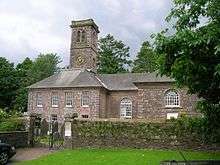
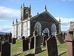
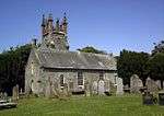
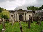
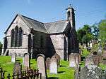
| Crossmichael Parish Church |
Crossmichael |
|
NX7297766985 |
54°58′52″N 3°59′11″W / 54.981219°N 3.986393°W / 54.981219; -3.986393 (Crossmichael Parish Church) |
Church of 1751 with 16th- or 17th-century tower[42] |
3698 |
 Upload another image
|
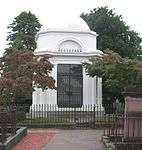
| Crossmichael Church, Gordon Memorial |
Crossmichael |
|
NX7299466978 |
54°58′52″N 3°59′10″W / 54.98116°N 3.986124°W / 54.98116; -3.986124 (Crossmichael Church, Gordon Memorial) |
18th-century classical burial enclosure[43] |
3699 |
|
| Glenlochar Bridge |
Glenlochar |
|
NX7320664512 |
54°57′33″N 3°58′54″W / 54.959068°N 3.981722°W / 54.959068; -3.981722 (Glenlochar Bridge) |
Five-arch stone bridge circa 1797[44] |
3706 |
|
| Greenlaw House |
Castle Douglas |
|
NX7541364412 |
54°57′31″N 3°56′50″W / 54.958726°N 3.947234°W / 54.958726; -3.947234 (Greenlaw House) |
18th-century classical villa, gutted by fire in the 1980s[45] |
3708 |
|
| Southwick Home Farm |
Caulkerbush, Southerness |
|
NX9366756930 |
54°53′45″N 3°39′34″W / 54.89575°N 3.659532°W / 54.89575; -3.659532 (Southwick Home Farm) |
Large, well-preserved 19th-century steading and water mill[46] |
3723 |
 Upload another image
|
| Stapleton Tower |
Dornock |
|
NY2347168871 |
55°00′31″N 3°11′53″W / 55.00849°N 3.198134°W / 55.00849; -3.198134 (Stapleton Tower) |
16th-century tower house[47] |
3782 |
 Upload another image
See more images
|
| Dornock House, old farmhouse and steading |
Dornock |
|
NY2315865990 |
54°58′57″N 3°12′08″W / 54.982558°N 3.202253°W / 54.982558; -3.202253 (Dornock House, old farmhouse and steading) |
18th-century farmstead complex[48] |
3792 |
|
| Caerlaverock Castle |
Caerlaverock |
|
NY0254865638 |
54°58′33″N 3°31′27″W / 54.975787°N 3.524068°W / 54.975787; -3.524068 (Caerlaverock Castle) |
Substantial remains of late-13th-century moated castle[49] |
3799 |
 Upload another image
See more images
|
| Ladyfield West (formerly Hannayfield) |
Dumfries |
|
NX9780174401 |
55°03′13″N 3°36′05″W / 55.05355°N 3.601336°W / 55.05355; -3.601336 (Ladyfield West (formerly Hannayfield)) |
Villa of 1830 by Walter Newall[50] |
3829 |
|
| Crichton Royal Hospital, Crichton Hall |
The Crichton, Dumfries |
|
NX9810274396 |
55°03′13″N 3°35′48″W / 55.053567°N 3.596624°W / 55.053567; -3.596624 (Crichton Royal Hospital, Crichton Hall) |
Hospital building by William Burn, opened 1839 with later additions[51] |
3839 |
|
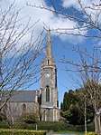
| Durisdeer Parish Church and Queensberry Mausoleum |
Durisdeer |
|
NS8940703770 |
55°18′56″N 3°44′39″W / 55.315535°N 3.744157°W / 55.315535; -3.744157 (Durisdeer Parish Church and Queensberry Mausoleum) |
Church of 1720 by James Smith, adjacent mausoleum to Duke of Queensberry with sculpture by John Van Nost[52] |
3856 |
 Upload another image
See more images
|
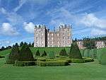
| Drumlanrig Castle |
Carronbridge, Thornhill |
|
NX8519099214 |
55°16′25″N 3°48′31″W / 55.27365°N 3.808705°W / 55.27365; -3.808705 (Drumlanrig Castle) |
Courtyard castle remodelled 1689, probably to design of Robert Mylne[53] |
3886 |
 Upload another image
See more images
|
| Wallacehall Assessment Centre (former Academy and Schoolhouse) |
Closeburn |
|
NX9025192409 |
55°12′49″N 3°43′35″W / 55.213684°N 3.726433°W / 55.213684; -3.726433 (Wallacehall Assessment Centre (former Academy and Schoolhouse)) |
18th-century school house[54] |
3953 |
|
| Auldgirth Bridge |
Auldgirth |
|
NX9116586353 |
55°09′34″N 3°42′35″W / 55.159492°N 3.709743°W / 55.159492; -3.709743 (Auldgirth Bridge) |
Three-arch road bridge of 1782 by David Henderson[55] |
3966 |
 Upload another image
|
| Dalgonar Bridge |
Dunscore, over Cairn Water |
|
NX8602984080 |
55°08′17″N 3°47′22″W / 55.13792°N 3.789397°W / 55.13792; -3.789397 (Dalgonar Bridge) |
Single-arch stone bridge dated 1818[56] |
4227 |
|
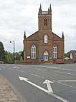
| Dunscore Parish Church |
Dunscore |
|
NX8666184340 |
55°08′25″N 3°46′47″W / 55.1404°N 3.779592°W / 55.1404; -3.779592 (Dunscore Parish Church) |
Gothic church of 1824 by James Thomson of Dumfries[57] |
4230 |
 Upload another image
|
| Ellisland Farm |
Auldgirth |
|
NX9298783850 |
55°08′15″N 3°40′49″W / 55.137408°N 3.680215°W / 55.137408; -3.680215 (Ellisland Farm) |
1788 farm built for the poet Robert Burns, now a museum[58] |
4232 |
 Upload another image
See more images
|
| Crichton Farm |
The Crichton, Dumfries |
|
NX9833473772 |
55°02′53″N 3°35′34″W / 55.048009°N 3.592771°W / 55.048009; -3.592771 (Crichton Farm) |
Extensive industrial farm complex, built 1893[59] |
6693 |
|
| Crichton Memorial Church |
The Crichton, Dumfries |
|
NX9825174093 |
55°03′03″N 3°35′39″W / 55.050875°N 3.594185°W / 55.050875; -3.594185 (Crichton Memorial Church) |
Large Gothic church of 1897, by Sydney Mitchell and Wilson[60] |
6695 |
 Upload another image
See more images
|
| Hills Tower |
Cargenbridge |
|
NX9122472666 |
55°02′12″N 3°42′13″W / 55.036568°N 3.703579°W / 55.036568; -3.703579 (Hills Tower) |
16th-century tower house and 18th-century house[61] |
9715 |
 Upload another image
|
| Duchess Bridge |
Langholm Lodge, over the River Esk, Langholm |
|
NY3559385239 |
55°09′26″N 3°00′44″W / 55.157269°N 3.01234°W / 55.157269; -3.01234 (Duchess Bridge) |
Cast-iron bridge built 1813, probably the earliest existing iron bridge in Scotland[62] |
9734 |
 Upload another image
|
| Knocknalling Barn |
Knocknalling, St John's Town of Dalry |
|
NX5964584846 |
55°08′17″N 4°12′12″W / 55.138021°N 4.203352°W / 55.138021; -4.203352 (Knocknalling Barn) |
Mid-19th-century stone barn with triangular vents[63] |
9746 |
|
| Milnholm Farmhouse and Steading |
Langholm |
|
NY3551687288 |
55°10′32″N 3°00′50″W / 55.175668°N 3.014016°W / 55.175668; -3.014016 (Milnholm Farmhouse and Steading) |
Later 19th-century farm and steading[64] |
9763 |
|
| Skipper's Bridge (A7 Over River Esk) |
Langholm, carrying the A7 over the River Esk |
|
NY3706683400 |
55°08′27″N 2°59′20″W / 55.140936°N 2.988818°W / 55.140936; -2.988818 (Skipper's Bridge (A7 Over River Esk)) |
Three-arch road bridge of circa 1700[65] |
9764 |
 Upload another image
|
| Mossknowe House |
Kirkpatrick Fleming |
|
NY2810369766 |
55°01′02″N 3°07′33″W / 55.017222°N 3.12595°W / 55.017222; -3.12595 (Mossknowe House) |
Palladian mansion of unusual composition, dated 1767[66] |
9799 |
|
| Springkell House |
Eaglesfield |
|
NY2550775184 |
55°03′56″N 3°10′05″W / 55.065516°N 3.167956°W / 55.065516; -3.167956 (Springkell House) |
Palladian mansion dated 1734[67] |
9805 |
|
| Wyseby, former stables with dovecot |
Kirtlebridge |
|
NY2409972480 |
55°02′28″N 3°11′21″W / 55.04101°N 3.189277°W / 55.04101; -3.189277 (Wyseby, former stables with dovecot) |
Mid-18th-century stables and early 19th century dovecot[68] |
9808 |
|
| Graham of Mossknowe burial enclosure |
Kirkpatrick Fleming Parish Churchyard, Kirkpatrick Fleming |
|
NY2763770091 |
55°01′12″N 3°08′00″W / 55.020074°N 3.133319°W / 55.020074; -3.133319 (Graham of Mossknowe burial enclosure) |
Later 17th-century Renaissance burial enclosure[69] |
9813 |
|
| Douglas Mausoleum, near to Kelton Parish Church |
Kelton |
|
NX7587560348 |
54°55′20″N 3°56′18″W / 54.922342°N 3.938266°W / 54.922342; -3.938266 (Douglas Mausoleum, near to Kelton Parish Church) |
Pyramidal mausoleum, built circa 1820 for James Douglas [70] |
9835 |
 Upload another image
|
| Gelston Castle |
Gelston, Castle Douglas |
|
NX7772158343 |
54°54′17″N 3°54′31″W / 54.904791°N 3.908628°W / 54.904791; -3.908628 (Gelston Castle) |
Country house in Adam castellated style, 1805, attributed to Richard Crichton, now derelict[71] |
9836 |
.jpg) Upload another image
See more images
|
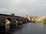
| Old Bridge of Dee |
Bridge of Dee, Castle Douglas, over the River Dee |
|
NX7343159958 |
54°55′06″N 3°58′34″W / 54.918226°N 3.976203°W / 54.918226; -3.976203 (Old Bridge of Dee) |
18th-century four-arch bridge[72] |
9838 |
.jpg) Upload another image
See more images
|
| Craigielands House |
Beattock |
|
NT0764401561 |
55°17′58″N 3°27′22″W / 55.299457°N 3.456184°W / 55.299457; -3.456184 (Craigielands House) |
Greek-revival villa by William Burn, 1817[73] |
9842 |
|
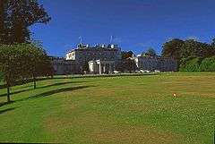
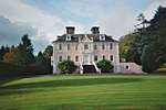
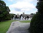
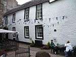
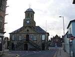
| Cally Palace Hotel, formerly Cally House |
Gatehouse of Fleet |
|
NX5998254946 |
54°52′11″N 4°11′00″W / 54.869627°N 4.183429°W / 54.869627; -4.183429 (Cally Palace Hotel, formerly Cally House) |
Classically detailed country house, built 1765 by Robert Mylne[74] |
9854 |
 Upload another image
See more images
|
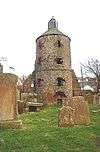
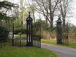
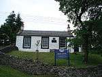
| Girthon Old Kirk churchyard |
Girthon, Gatehouse of Fleet |
|
NX6055053379 |
54°51′21″N 4°10′26″W / 54.855715°N 4.173828°W / 54.855715; -4.173828 (Girthon Old Kirk churchyard) |
17th-century churchyard[75] |
9859 |
 Upload another image
|
| Raehills House |
St Ann's, Johnstonebridge |
|
NY0637594336 |
55°14′04″N 3°28′26″W / 55.234316°N 3.473759°W / 55.234316; -3.473759 (Raehills House) |
18th-century mansion by Alexander Stevens, remodelled in 1834 by William Burn[76] |
9898 |
 Upload another image
|
| The Old Brig Inn |
Beattock |
|
NT0775402830 |
55°18′39″N 3°27′18″W / 55.310877°N 3.45487°W / 55.310877; -3.45487 (The Old Brig Inn) |
Coaching inn of 1821 by Thomas Telford[77] |
9908 |
 Upload another image
|
| Hutton and Corrie Parish Church |
Boreland |
|
NY1704890833 |
55°12′17″N 3°18′18″W / 55.204759°N 3.304951°W / 55.204759; -3.304951 (Hutton and Corrie Parish Church) |
Early-18th-century church[78] |
9911 |
 Upload another image
|
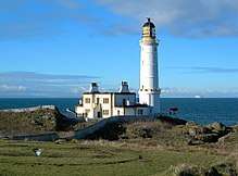
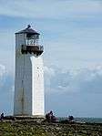
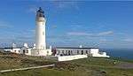
| Corsewall Lighthouse |
Corsewall Point, Stranraer |
|
NW9807572614 |
55°00′25″N 5°09′33″W / 55.007°N 5.159167°W / 55.007; -5.159167 (Corsewall Lighthouse) |
Lighthouse and keeper's house 1815 by Robert Stevenson, 1889 additions by David Alan Stevenson[79] |
9923 |
 Upload another image
See more images
|
| Kinnel Bridge |
Lochmaben, B7020 over Kinnel Water |
|
NY0894085010 |
55°09′04″N 3°25′50″W / 55.151021°N 3.430433°W / 55.151021; -3.430433 (Kinnel Bridge) |
18th-century three-arch road bridge, widened in the 19th century[80] |
9950 |
 Upload another image
|
| Spedlins Tower |
Millhousebridge |
|
NY0976787553 |
55°10′26″N 3°25′06″W / 55.174017°N 3.418271°W / 55.174017; -3.418271 (Spedlins Tower) |
15th-century tower house, remodelled circa 1605, and restored in the 1980s[81] |
9965 |
.jpg) Upload another image
See more images
|
| Elshieshields Tower |
Elshieshields, Lochmaben |
|
NY0688885034 |
55°09′03″N 3°27′45″W / 55.150854°N 3.462629°W / 55.150854; -3.462629 (Elshieshields Tower) |
16th-century L-plan tower house and early-18th-century house[82] |
9970 |
|
| Halleaths Former Stables |
Halleaths, Lochmaben |
|
NY0973582323 |
55°07′37″N 3°25′02″W / 55.127029°N 3.417107°W / 55.127029; -3.417107 (Halleaths Former Stables) |
Large stable court dated 1843, in the style of Walter Newall[83] |
9971 |
|
| Hoddom Bridge |
Hoddom, Brydekirk, over River Annan |
|
NY1636272716 |
55°02′31″N 3°18′37″W / 55.041887°N 3.310386°W / 55.041887; -3.310386 (Hoddom Bridge) |
18th-century three-arch stone bridge[84] |
10026 |
 Upload another image
|
| Shortrig Windmill Tower, Horsemill and Steading |
Shortrigg, Ecclefechan |
|
NY1614374371 |
55°03′24″N 3°18′51″W / 55.056718°N 3.314299°W / 55.056718; -3.314299 (Shortrig Windmill Tower, Horsemill and Steading) |
18th-century windmill, early-19th-century horse-mill, and 18th-19th-century courtyard steading[85] |
10041 |
|
| Arched House including Carlyle's Birthplace |
Ecclefechan High Street |
|
NY1934574582 |
55°03′33″N 3°15′51″W / 55.059144°N 3.264246°W / 55.059144; -3.264246 (Arched House including Carlyle's Birthplace) |
18th-century pair of houses, including the birthplace of writer Thomas Carlyle[86] |
10065 |
 Upload another image
See more images
|
| Kirkcowan Parish Church |
Kirkcowan |
|
NX3273960968 |
54°54′55″N 4°36′40″W / 54.915318°N 4.611004°W / 54.915318; -4.611004 (Kirkcowan Parish Church) |
Gothic church built 1834[87] |
10066 |
 Upload another image
See more images
|
| Craichlaw House |
Craighlaw, Kirkcowan |
|
NX3063661091 |
54°54′57″N 4°38′38″W / 54.915713°N 4.643847°W / 54.915713; -4.643847 (Craichlaw House) |
16th-century tower house and adjoining 19th-century Baronial mansion by Wardrop and Brown[88] |
10076 |
|
| Barholm Castle |
Barholm, Gatehouse of Fleet |
|
NX5207352959 |
54°50′58″N 4°18′20″W / 54.849509°N 4.305549°W / 54.849509; -4.305549 (Barholm Castle) |
17th-century L-plan tower house, restored in the early 21st century[89] |
10093 |
 Upload another image
See more images
|
| Carsluith Castle |
Carsluith, Gatehouse of Fleet |
|
NX4946454151 |
54°51′34″N 4°20′48″W / 54.859433°N 4.346769°W / 54.859433; -4.346769 (Carsluith Castle) |
Late-15th-century tower house with later additions [90] |
10104 |
 Upload another image
See more images
|
| Baldoon Castle Gatepiers |
Bladnoch, Wigtown |
|
NX4257453624 |
54°51′09″N 4°27′13″W / 54.852581°N 4.453716°W / 54.852581; -4.453716 (Baldoon Castle Gatepiers) |
Mid-17th-century Renaissance gatepiers[91] |
10109 |
 Upload another image
See more images
|
| Old Place of Monreith, or Dowies |
Monreith, Glasserton |
|
NX3811943013 |
54°45′21″N 4°31′02″W / 54.755897°N 4.517105°W / 54.755897; -4.517105 (Old Place of Monreith, or Dowies) |
Early-17th-century tower house of unusual plan, restored in the 19th century and in the 1980s[92] |
10123 |
 Upload another image
See more images
|
| Ravenstone Castle |
Drumjin, Whithorn |
|
NX4092044181 |
54°46′02″N 4°28′27″W / 54.767279°N 4.474263°W / 54.767279; -4.474263 (Ravenstone Castle) |
16th-century L-plan tower house with later additions, now derelict[93] |
10133 |
 Upload another image
See more images
|
| Glasserton Parish Church |
Glasserton |
|
NX4212138087 |
54°42′47″N 4°27′08″W / 54.712944°N 4.452305°W / 54.712944; -4.452305 (Glasserton Parish Church) |
18th-century church, with 19th-century tower and session house[94] |
10137 |
 Upload another image
|
| Craigcaffie Tower |
Craigcaffie, Stranraer |
|
NX0886364124 |
54°56′06″N 4°59′06″W / 54.935072°N 4.98507°W / 54.935072; -4.98507 (Craigcaffie Tower) |
16th-century tower house, restored in 1983[95] |
10164 |
 Upload another image
See more images
|
| Lochryan House |
Cairnryan |
|
NX0640268772 |
54°58′33″N 5°01′36″W / 54.975833°N 5.026561°W / 54.975833; -5.026561 (Lochryan House) |
Early-18th-century mansion with 19th-century alterations[96] |
10168 |
.jpg) Upload another image
|
| Lochinch Castle |
Lochinch Estate, Castle Kennedy |
|
NX1062261778 |
54°54′53″N 4°57′22″W / 54.914689°N 4.956108°W / 54.914689; -4.956108 (Lochinch Castle) |
Baronial mansion by Brown and Wardrop, 1868[97] |
10179 |
.jpg) Upload another image
|
| Castle Kennedy |
Lochinch Estate, Castle Kennedy |
|
NX1104860936 |
54°54′26″N 4°56′56″W / 54.907294°N 4.948919°W / 54.907294; -4.948919 (Castle Kennedy) |
Remains of early-17th-century tower house, burned down 1716[98] |
10181 |
.jpg) Upload another image
See more images
|
| Old Bridge of Urr Mill |
Old Bridge of Urr, Kirkpatrick Durham |
|
NX7765167700 |
54°59′20″N 3°54′49″W / 54.988811°N 3.913709°W / 54.988811; -3.913709 (Old Bridge of Urr Mill) |
Water mill with rare surviving timber-framed water wheel[99] |
10191 |
 Upload another image
|
| Fourmerkland Tower |
Fourmerkland, Dumfries |
|
NX9085680755 |
55°06′33″N 3°42′45″W / 55.109143°N 3.712436°W / 55.109143; -3.712436 (Fourmerkland Tower) |
Late-16th-century tower house[100] |
10204 |
 Upload another image
See more images
|
| West Gallaberry Farm Steading and Horsemill |
Kirkton, Locharbriggs |
|
NX9641682622 |
55°07′38″N 3°37′34″W / 55.127107°N 3.626001°W / 55.127107; -3.626001 (West Gallaberry Farm Steading and Horsemill) |
Early-19th-century steading courtyard[101] |
10218 |
|
| Blackwood House Former Stables |
Auldgirth |
|
NX9069387009 |
55°09′55″N 3°43′03″W / 55.16528°N 3.717401°W / 55.16528; -3.717401 (Blackwood House Former Stables) |
18th-century stable courtyard with dovecot tower[102] |
10244 |
|
| Capenoch House |
Penpont |
|
NX8434493811 |
55°13′30″N 3°49′11″W / 55.224927°N 3.819795°W / 55.224927; -3.819795 (Capenoch House) |
Baronial mansion completed in 1868 by David Bryce[103] |
10247 |
|
| Kilneiss House |
Moniaive |
|
NX7737191018 |
55°11′53″N 3°55′41″W / 55.19816°N 3.928138°W / 55.19816; -3.928138 (Kilneiss House) |
Arts and Crafts cottage by John James Burnet for the artist James Paterson[104] |
10298 |
|
| Carnsalloch House |
Kirkton, Locharbriggs |
|
NX9709280300 |
55°06′23″N 3°36′52″W / 55.106391°N 3.614563°W / 55.106391; -3.614563 (Carnsalloch House) |
Palladian mansion house dated 1759[105] |
10300 |
|
| Carnsalloch Chapel at The Mount |
Kirkton, Locharbriggs |
|
NX9746780953 |
55°06′44″N 3°36′32″W / 55.112334°N 3.608923°W / 55.112334; -3.608923 (Carnsalloch Chapel at The Mount) |
Small Gothic chapel by Edward Buckton Lamb circa 1850[106] |
10301 |
|
| Carnsalloch Former Stables |
Kirkton, Locharbriggs |
|
NX9731880394 |
55°06′26″N 3°36′40″W / 55.107282°N 3.611056°W / 55.107282; -3.611056 (Carnsalloch Former Stables) |
18th-century classical stable courtyard[107] |
10303 |
|
| Glenluiart House |
Moniaive |
|
NX7642890867 |
55°11′48″N 3°56′34″W / 55.196569°N 3.942878°W / 55.196569; -3.942878 (Glenluiart House) |
Arts and Crafts mansion of 1900 by William West Neve[108] |
10307 |
 Upload another image
|
| Glencairn Parish Church |
Kirkland, Moniaive |
|
NX8090690471 |
55°11′39″N 3°52′21″W / 55.194112°N 3.872404°W / 55.194112; -3.872404 (Glencairn Parish Church) |
Gothic church built 1836[109] |
10312 |
.jpg) Upload another image
|
| Craigdarroch House |
Moniaive |
|
NX7414290903 |
55°11′47″N 3°58′44″W / 55.196315°N 3.978784°W / 55.196315; -3.978784 (Craigdarroch House) |
Classical mansion, dated 1729, by William Adam[110] |
10340 |
 Upload another image
|
| Ross Mains |
Templand |
|
NY0667488659 |
55°11′00″N 3°28′02″W / 55.183377°N 3.467181°W / 55.183377; -3.467181 (Ross Mains) |
Early classical house, dated 1728, possibly by James Smith[111] |
10353 |
 Upload another image
|
| John Paul Jones' Cottage |
Arbigland, Kirkbean |
|
NX9876157150 |
54°53′56″N 3°34′49″W / 54.898785°N 3.580215°W / 54.898785; -3.580215 (John Paul Jones' Cottage) |
18th-century cottage, birthplace in 1747 of Admiral John Paul Jones[112] |
10397 |
Upload another image
|
| Arbigland House |
Arbigland, Kirkbean |
|
NX9897957430 |
54°54′05″N 3°34′37″W / 54.901344°N 3.576916°W / 54.901344; -3.576916 (Arbigland House) |
Mid-18th-century Classical mansion house, built for and probably by William Craik of Arbigland[113] |
10398 |
|
| Southerness Lighthouse |
Southerness |
|
NX9774554282 |
54°52′22″N 3°35′42″W / 54.872815°N 3.595033°W / 54.872815; -3.595033 (Southerness Lighthouse) |
Built in 1748 as a navigational marker, lighthouse built circa 1811, rebuilt by Walter Newall 1842-3[114] |
10415 |
 Upload another image
See more images
|
| Shennanton House |
Shennanton, Kirkcowan |
|
NX3401664310 |
54°56′45″N 4°35′35″W / 54.945745°N 4.593035°W / 54.945745; -4.593035 (Shennanton House) |
English vernacular country house of 1908 by Henry Edward Clifford[115] |
13106 |
|
| Kirkdale Bridge |
On the A75 between Gatehouse of Fleet and Creetown |
|
NX5172853094 |
54°51′02″N 4°18′40″W / 54.850619°N 4.310987°W / 54.850619; -4.310987 (Kirkdale Bridge) |
1787 bridge designed by Robert Adam [116] |
13137 |
|
| Kirkdale House and Sundial |
Kirkdale, Gatehouse of Fleet |
|
NX5147253288 |
54°51′08″N 4°18′54″W / 54.852285°N 4.31507°W / 54.852285; -4.31507 (Kirkdale House and Sundial) |
1787 country house by Robert Adam, now flats[117] |
13138 |
 Upload another image
|
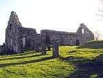
| Kirkdale Kirk and Kirkdale Mausoleum |
Kirkdale, Gatehouse of Fleet |
|
NX5121354055 |
54°51′33″N 4°19′10″W / 54.859095°N 4.319496°W / 54.859095; -4.319496 (Kirkdale Kirk and Kirkdale Mausoleum) |
Ruins of 18th-century Old Kirk of Kirkdale and classical mausoleum dated 1787, probably by Robert Adam[118] |
13139 |
.jpg) Upload another image
|
| Kirkdale Steadings and Slaughterhouse |
Kirkdale, Gatehouse of Fleet |
|
NX5128453605 |
54°51′18″N 4°19′05″W / 54.855075°N 4.318159°W / 54.855075; -4.318159 (Kirkdale Steadings and Slaughterhouse) |
1787 steading, probably by Robert Adam[119] |
13140 |
|
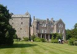
| Lochnaw Castle |
Leswalt, Stranraer |
|
NW9913262825 |
54°55′11″N 5°08′09″W / 54.919594°N 5.13581°W / 54.919594; -5.13581 (Lochnaw Castle) |
16th-century tower house and 17th-century L-plan range[120] |
13498 |
 Upload another image
See more images
|
| Lochnaw, Walled Garden |
Leswalt, Stranraer |
|
NW9885063069 |
54°55′18″N 5°08′25″W / 54.92167°N 5.140373°W / 54.92167; -5.140373 (Lochnaw, Walled Garden) |
Early-19th-century polygonal walled garden[121] |
13505 |
|
| Logan House |
Logan, Rhins of Galloway |
|
NX0964542824 |
54°44′39″N 4°57′32″W / 54.744217°N 4.958851°W / 54.744217; -4.958851 (Logan House) |
Classical mansion of 1702, remodelled 1952[122] |
13564 |
.jpg) Upload another image
|
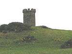
| Logan Windmill |
Logan, Rhins of Galloway |
|
NX1151643792 |
54°45′13″N 4°55′50″W / 54.75361°N 4.930454°W / 54.75361; -4.930454 (Logan Windmill) |
Tower of 17th-century windmill[123] |
13570 |
 Upload another image
|
| Mull of Galloway Lighthouse |
Mull of Galloway |
|
NX1569230398 |
54°38′06″N 4°51′26″W / 54.634944°N 4.857186°W / 54.634944; -4.857186 (Mull of Galloway Lighthouse) |
Lighthouse and keeper's house by Robert Stevenson, 1828[124] |
13578 |
 Upload another image
|
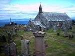
| Old Parish Church of Kirkmaiden |
Kirkmaiden, Rhins of Galloway |
|
NX1245036920 |
54°41′32″N 4°54′42″W / 54.692284°N 4.911533°W / 54.692284; -4.911533 (Old Parish Church of Kirkmaiden) |
17th-century T-plan church[125] |
13581 |
 Upload another image
|
| Kirkmadrine Church |
Sandhead, Rhins of Galloway |
|
NX0801448389 |
54°47′37″N 4°59′16″W / 54.793539°N 4.987833°W / 54.793539; -4.987833 (Kirkmadrine Church) |
Late-19th-century mausoleum chapel[126] |
16739 |
 Upload another image
See more images
|
| Portpatrick Old Parish Church |
Portpatrick |
|
NW9997654212 |
54°50′34″N 5°07′00″W / 54.842649°N 5.116686°W / 54.842649; -5.116686 (Portpatrick Old Parish Church) |
Remains of 17th-century church with earlier round tower, possibly a lighthouse[127] |
16743 |
 Upload another image
|
| Isle Castle |
Isle of Whithorn |
|
NX4764836604 |
54°42′05″N 4°21′57″W / 54.701333°N 4.365815°W / 54.701333; -4.365815 (Isle Castle) |
Small, 17th-century L-plan tower house[128] |
16751 |
 Upload another image
See more images
|
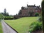
| Castle of Park |
Glenluce |
|
NX1881457126 |
54°52′34″N 4°49′32″W / 54.875976°N 4.825551°W / 54.875976; -4.825551 (Castle of Park) |
Late-16th-century L-plan tower house[129] |
16761 |
 Upload another image
See more images
|
| Haugh Bridge |
Haugh of Urr, over Urr Water |
|
NX8054365980 |
54°58′27″N 3°52′04″W / 54.974065°N 3.867819°W / 54.974065; -3.867819 (Haugh Bridge) |
Two-arch stone bridge built 1763 as part of military road[130] |
16807 |
|
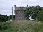
| Archbank Farm, tall barn with waterwheel |
Moffat |
|
NT0909606785 |
55°20′48″N 3°26′06″W / 55.346654°N 3.435018°W / 55.346654; -3.435018 (Archbank Farm, tall barn with waterwheel) |
Late-18th-century agricultural buildings[131] |
16847 |
|
| Granton House |
Moffat |
|
NT0745809907 |
55°22′28″N 3°27′43″W / 55.374392°N 3.461872°W / 55.374392; -3.461872 (Granton House) |
Small Greek Revival villa, circa 1830 by Walter Newall[132] |
16858 |
|
| Heatheryhaugh |
Moffat |
|
NT0924606246 |
55°20′31″N 3°25′57″W / 55.34184°N 3.432478°W / 55.34184; -3.432478 (Heatheryhaugh) |
Early-19th-century Gothic Revival villa[133] |
16861 |
|
| Cruggleton Church |
Garlieston |
|
NX4779642810 |
54°45′26″N 4°22′00″W / 54.757101°N 4.366768°W / 54.757101; -4.366768 (Cruggleton Church) |
Remains of 12th-century church, rebuilt c. 1890 by 3rd Marquis of Bute[134] |
16875 |
 Upload another image
See more images
|
| Galloway House |
Garlieston |
|
NX4784145273 |
54°46′45″N 4°22′02″W / 54.779229°N 4.367361°W / 54.779229; -4.367361 (Galloway House) |
18th-century house by John Douglas, additions by William Burn and Robert Lorimer[135] |
16876 |
 Upload another image
See more images
|
| Castlemilk |
Kettleholm, Lockerbie |
|
NY1493777471 |
55°05′04″N 3°20′03″W / 55.084362°N 3.334099°W / 55.084362; -3.334099 (Castlemilk) |
Scots Baronial mansion, 1865 by David Bryce[136] |
16888 |
|
| Castlemilk, Driveway Bridge |
Kettleholm, Lockerbie |
|
NY1504777261 |
55°04′57″N 3°19′56″W / 55.082494°N 3.332314°W / 55.082494; -3.332314 (Castlemilk, Driveway Bridge) |
Scots Baronial bridge, 1865 by David Bryce[137] |
16890 |
|
| Westerkirk Old Churchyard, Johnstone Mausoleum |
Bentpath, Eskdale |
|
NY3128690350 |
55°12′09″N 3°04′52″W / 55.202607°N 3.081164°W / 55.202607; -3.081164 (Westerkirk Old Churchyard, Johnstone Mausoleum) |
Classical mausoleum by Robert Adam, circa 1790. [138] |
16921 |
 Upload another image
|
| Bentpath Bridge |
Bentpath, over River Esk, Eskdale |
|
NY3116090248 |
55°12′06″N 3°04′59″W / 55.201674°N 3.083118°W / 55.201674; -3.083118 (Bentpath Bridge) |
Three-arch road bridge built circa 1736[139] |
16939 |
 Upload another image
|
| Barwhinnock House |
Twynholm |
|
NX6567954987 |
54°52′18″N 4°05′41″W / 54.871559°N 4.09474°W / 54.871559; -4.09474 (Barwhinnock House) |
Early-19th-century Classical house[140] |
16989 |
|
| Cumstoun House |
Tongland |
|
NX6832053319 |
54°51′26″N 4°03′10″W / 54.857282°N 4.052851°W / 54.857282; -4.052851 (Cumstoun House) |
Tudor Gothic house built 1829 by Thomas Hamilton[141] |
16993 |
.jpg) Upload another image
|
| Cumloden House |
Minnigaff, Newton Stewart |
|
NX4174367698 |
54°58′43″N 4°28′28″W / 54.978674°N 4.474392°W / 54.978674; -4.474392 (Cumloden House) |
Gothic cottage house, circa 1820[142] |
17052 |
 Upload another image
|
| Garlies Castle |
Minnigaff, Newton Stewart |
|
NX4221769145 |
54°59′31″N 4°28′04″W / 54.991816°N 4.46779°W / 54.991816; -4.46779 (Garlies Castle) |
Remains of late-15th- or early-16th-century castle[143] |
17057 |
.jpg) Upload another image
See more images
|
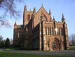
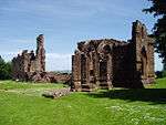
| Dundrennan Abbey |
Dundrennan |
|
NX7494147506 |
54°48′24″N 3°56′50″W / 54.806773°N 3.947261°W / 54.806773; -3.947261 (Dundrennan Abbey) |
Ruins of 12th-century Cistercian abbey[144] |
17072 |
.JPG) Upload another image
See more images
|
| Corsock House, Gates and Gatepiers |
Corsock |
|
NX7587475259 |
55°03′23″N 3°56′41″W / 55.056258°N 3.944749°W / 55.056258; -3.944749 (Corsock House, Gates and Gatepiers) |
Large, mid-19th-century ornamental Gothic cast-iron gates[145] |
17094 |
 Upload another image
|
| Argrennan House |
Bridge of Dee, Castle Douglas |
|
NX7146358085 |
54°54′03″N 4°00′22″W / 54.900902°N 4.006049°W / 54.900902; -4.006049 (Argrennan House) |
18th-century house, added to in the 19th century by James Gillespie Graham[146] |
17114 |
 Upload another image
|
| Old Tongland Bridge |
Tongland, over River Dee |
|
NX6969953655 |
54°51′38″N 4°01′54″W / 54.86066°N 4.031536°W / 54.86066; -4.031536 (Old Tongland Bridge) |
Tongland, over River Dee[147] |
17123 |
|
| Tongland Bridge |
Tongland, over River Dee |
|
NX6920053347 |
54°51′28″N 4°02′21″W / 54.857764°N 4.039165°W / 54.857764; -4.039165 (Tongland Bridge) |
Single-arch stone bridge built 1808 by Thomas Telford and Alexander Nasmyth[148] |
17125 |
 Upload another image
See more images
|
| Tongland Hydro-Electric Power Station |
Tongland |
|
NX6951253559 |
54°51′35″N 4°02′04″W / 54.859749°N 4.034404°W / 54.859749; -4.034404 (Tongland Hydro-Electric Power Station) |
Power station built 1934[149] |
17126 |
 Upload another image
|
| Torthorwald Cruck Cottage |
Torthorwald |
|
NY0326978477 |
55°05′29″N 3°31′02″W / 55.09126°N 3.51716°W / 55.09126; -3.51716 (Torthorwald Cruck Cottage) |
19th-century cruck-framed and thatched cottage[150] |
17157 |
 Upload another image
|
| Wanlockhead Village Library |
Wanlockhead |
|
NS8738912987 |
55°23′52″N 3°46′47″W / 55.397858°N 3.779649°W / 55.397858; -3.779649 (Wanlockhead Village Library) |
Small village library, dated 1850[151] |
17192 |
 Upload another image
|
| Goldielea Viaduct |
Goldielea, Cargenbridge |
|
NX9305073636 |
55°02′44″N 3°40′31″W / 55.045677°N 3.675385°W / 55.045677; -3.675385 (Goldielea Viaduct) |
18-arch former railway bridge opened 1859 as part of Castle Douglas to Dumfries railway[152] |
17201 |
 Upload another image
|
| Kirkconnel House |
Kirkconnel |
|
NX9799068033 |
54°59′47″N 3°35′46″W / 54.996387°N 3.596103°W / 54.996387; -3.596103 (Kirkconnel House) |
16th-century house with later additions[153] |
17204 |
|
| Terregles Estate Former Stables |
Terregles |
|
NX9315577637 |
55°04′54″N 3°40′31″W / 55.081638°N 3.675243°W / 55.081638; -3.675243 (Terregles Estate Former Stables) |
Stable block probably by Sir Robert Smirke, circa 1831[154] |
17208 |
|
| Tynron Parish Church |
Tynron |
|
NX8059093012 |
55°13′01″N 3°52′42″W / 55.216857°N 3.878439°W / 55.216857; -3.878439 (Tynron Parish Church) |
Gothic church by William Burn, built 1837[155] |
17222 |
 Upload another image
|
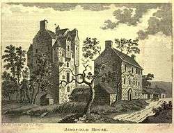
| Amisfield Tower |
Amisfield |
|
NX9920383800 |
55°08′18″N 3°34′58″W / 55.138264°N 3.582732°W / 55.138264; -3.582732 (Amisfield Tower) |
16th-century tower house[156] |
17233 |
 Upload another image
See more images
|
| Tinwald House |
Tinwald |
|
NY0173580289 |
55°06′26″N 3°32′31″W / 55.107235°N 3.541813°W / 55.107235; -3.541813 (Tinwald House) |
Classical mansion house by William Adam, dated 1740[157] |
17238 |
 Upload another image
|
| Tinwald House Cottages |
Tinwald |
|
NY0174380237 |
55°06′24″N 3°32′30″W / 55.106769°N 3.541669°W / 55.106769; -3.541669 (Tinwald House Cottages) |
Service quarters probably by William Adam, circa 1740[158] |
17239 |
|
| Tinwald House Farm Steading |
Tinwald |
|
NY0167680326 |
55°06′27″N 3°32′34″W / 55.107555°N 3.54275°W / 55.107555; -3.54275 (Tinwald House Farm Steading) |
Steading probably by William Adam, circa 1740[159] |
17240 |
|
| Comlongon Castle |
Clarencefield, Ruthwell |
4/11/1971 |
NY0794068950 |
55°00′24″N 3°26′27″W / 55.006566°N 3.440923°W / 55.006566; -3.440923 (Comlongon Castle) |
15th-century tower house and 1902 mansion house by James Barbour and J.M. Bowie[160] |
17245 |
 Upload another image
See more images
|
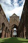
| Ruthwell Museum |
Ruthwell |
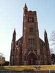
|
NY1018767387 |
54°59′35″N 3°24′19″W / 54.992936°N 3.405311°W / 54.992936; -3.405311 (Ruthwell Museum) |
Built circa 1760, former Henry Duncan Savings Bank opened 1810 as Scotland's first savings bank[161] |
17249 |
 Upload another image
|
| Nith Bridge |
Thornhill, over River Nith |
|
NX8708195480 |
55°14′26″N 3°46′39″W / 55.240551°N 3.777458°W / 55.240551; -3.777458 (Nith Bridge) |
Later 18th-century two-arch stone road bridge[162] |
17286 |
_-_geograph.org.uk_-_533035.jpg) Upload another image
See more images
|
| Drumlanrig Low Gardens House (Gardeners House) |
Drumlanrig Estate |
|
NX8576298206 |
55°15′53″N 3°47′57″W / 55.26473°N 3.799297°W / 55.26473; -3.799297 (Drumlanrig Low Gardens House (Gardeners House)) |
Picturesque cottage by William Burn, circa 1831[163] |
17297 |
|
| Sweetheart Abbey |
New Abbey |
|
NX9650666270 |
54°58′49″N 3°37′07″W / 54.980244°N 3.618652°W / 54.980244; -3.618652 (Sweetheart Abbey) |
Remains of Cistercian abbey founded in 1273[164] |
17304 |
 Upload another image
See more images
|
| New Abbey Mill (Monksmill) |
New Abbey |
|
NX9622966249 |
54°58′48″N 3°37′23″W / 54.979998°N 3.622971°W / 54.979998; -3.622971 (New Abbey Mill (Monksmill)) |
Mid to late-18th-century water-mill, in working order[165] |
17323 |
 Upload another image
See more images
|
| Thornhill Cross |
Thornhill |
|
NX8787995478 |
55°14′27″N 3°45′54″W / 55.240715°N 3.764914°W / 55.240715; -3.764914 (Thornhill Cross) |
Mercat cross erected 1714, possibly by James Smith[166] |
17337 |
 Upload another image
|
| The Old House |
New Abbey |
|
NX9618566225 |
54°58′47″N 3°37′25″W / 54.979773°N 3.623649°W / 54.979773; -3.623649 (The Old House) |
17th-century house[167] |
17346 |
|
| Monument to Henry Duncan |
Mount Kedar, Mouswald |
|
NY0718871551 |
55°01′47″N 3°27′13″W / 55.029791°N 3.453521°W / 55.029791; -3.453521 (Monument to Henry Duncan) |
Monument by James Raeburn, erected 1846 to the Rev. Henry Duncan (1774–1846)[168] |
17388 |
|
| Sorbie Tower |
Sorbie |
|
NX4508947025 |
54°47′39″N 4°24′40″W / 54.794117°N 4.411044°W / 54.794117; -4.411044 (Sorbie Tower) |
Late-16th-century tower house[169] |
19181 |
 Upload another image
See more images
|
| All Saints Episcopal Church |
Challoch, Newton Stewart |
|
NX3851767485 |
54°58′33″N 4°31′29″W / 54.975727°N 4.524626°W / 54.975727; -4.524626 (All Saints Episcopal Church) |
Gothic Revival church by William Habershon and Alfred Pite, built 1872[170] |
19190 |
 Upload another image
|
| Tonderghie House |
Isle of Whithorn |
|
NX4430535670 |
54°41′31″N 4°25′02″W / 54.691924°N 4.417144°W / 54.691924; -4.417144 (Tonderghie House) |
Mid-18th-century country house[171] |
19248 |
 Upload another image
|
| Tonderghie Steadings |
Isle of Whithorn |
|
NX4420535389 |
54°41′22″N 4°25′07″W / 54.68937°N 4.418544°W / 54.68937; -4.418544 (Tonderghie Steadings) |
19th-century steading with an almost complete horse-powered threshing machine[172] |
19249 |
|
| Heron Monument |
Monigaff Parish Churchyard, Minnigaff |
|
NX4099066573 |
54°58′06″N 4°29′08″W / 54.968335°N 4.485521°W / 54.968335; -4.485521 (Heron Monument) |
Classical monument of the Heron family, dated 1761[173] |
19313 |
|
| Monreith House |
Port William |
|
NX3557742864 |
54°45′13″N 4°33′23″W / 54.753733°N 4.556479°W / 54.753733; -4.556479 (Monreith House) |
Classical mansion house by Alexander Stevens, built 1791 [174] |
19561 |
 Upload another image
See more images
|
| Old Place of Mochrum |
Culshabbin, Mochrum |
|
NX3080554053 |
54°51′09″N 4°38′13″W / 54.852592°N 4.637081°W / 54.852592; -4.637081 (Old Place of Mochrum) |
Two 16th-century towers linked and restored in the later 19th-century[175] |
19570 |
 Upload another image
See more images
|
| Annan Bridge |
Annan, carrying the A75 over the River Annan |
|
NY1910766585 |
54°59′14″N 3°15′57″W / 54.987261°N 3.265704°W / 54.987261; -3.265704 (Annan Bridge) |
Three-arch road bridge by Robert Stevenson, 1826[176] |
21061 |
 Upload another image
|
| 27, 29 Bank Street |
Annan |
|
NY1933466461 |
54°59′10″N 3°15′44″W / 54.986184°N 3.262123°W / 54.986184; -3.262123 (27, 29 Bank Street) |
Former British Linen Bank in the style of Walter Newall, circa 1840[177] |
21066 |
|
| 5, 7, 9 High Street (Old Academy) |
Annan |
|
NY1916166537 |
54°59′13″N 3°15′53″W / 54.986839°N 3.264847°W / 54.986839; -3.264847 (5, 7, 9 High Street (Old Academy)) |
Mid-18th-century town house, formerly the burgh academy[178] |
21086 |
.jpg) Upload another image
|
| Annan Old Parish Church |
Annan, High Street |
|
NY1958466612 |
54°59′15″N 3°15′30″W / 54.987581°N 3.25826°W / 54.987581; -3.25826 (Annan Old Parish Church) |
Parish church with classical details, dated 1789[179] |
21106 |
.jpg) Upload another image
|
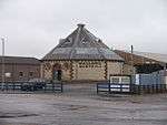
| Castle Douglas Cattle Mart |
Castle Douglas |
|
NX7681962564 |
54°56′33″N 3°55′28″W / 54.942479°N 3.924496°W / 54.942479; -3.924496 (Castle Douglas Cattle Mart) |
Octagonal cattle market built 1900[180] |
22976 |
 Upload another image
|
| Lincluden Collegiate Church |
Lincluden, Dumfries |
|
NX9664077911 |
55°05′05″N 3°37′15″W / 55.084838°N 3.620776°W / 55.084838; -3.620776 (Lincluden Collegiate Church) |
Ruins of 14th- or 15th-century church[181] |
26075 |
 Upload another image
See more images
|
| 5, 7, 9, 11 Bank Street |
Dumfries |
|
NX9713076011 |
55°04′04″N 3°36′45″W / 55.067873°N 3.612416°W / 55.067873; -3.612416 (5, 7, 9, 11 Bank Street) |
Mid-18th-century town house, former home of Robert Burns[182] |
26083 |
|
| Former Methodist Church |
Dumfries, Buccleuch Street |
|
NX9706976286 |
55°04′13″N 3°36′48″W / 55.07033°N 3.61347°W / 55.07033; -3.61347 (Former Methodist Church) |
Classical church by Thomas Hunt, 1817[183] |
26102 |
 Upload another image
|
| Robert Burns' House |
Dumfries, Burns Street |
|
NX9740675806 |
55°03′58″N 3°36′29″W / 55.066089°N 3.608022°W / 55.066089; -3.608022 (Robert Burns' House) |
18th-century house in which Robert Burns lived from 1793 until his death in 1796[184] |
26115 |
 Upload another image
See more images
|
| 25–37 Castle Street (odd numbers) |
Dumfries |
|
NX9706276295 |
55°04′13″N 3°36′49″W / 55.07041°N 3.613583°W / 55.07041; -3.613583 (25–37 Castle Street (odd numbers)) |
Terrace of seven houses built circa 1830 to design by Robert Burn[185] |
26118 |
|
| 41, 43, 45, 47 Castle Street |
Dumfries |
|
NX9698976395 |
55°04′17″N 3°36′53″W / 55.071293°N 3.614762°W / 55.071293; -3.614762 (41, 43, 45, 47 Castle Street) |
Terrace built in the 1820s to design by Robert Burn [186] |
26120 |
|
| 14-24 Castle Street (even numbers) |
Dumfries |
|
NX9710076299 |
55°04′14″N 3°36′47″W / 55.070454°N 3.61299°W / 55.070454; -3.61299 (14-24 Castle Street (even numbers)) |
Terrace built between 1806 and 1819 to design by Robert Burn[187] |
26122 |
|
| 26, 28, 30 Castle Street |
Dumfries |
|
NX9702776398 |
55°04′17″N 3°36′51″W / 55.071328°N 3.614168°W / 55.071328; -3.614168 (26, 28, 30 Castle Street) |
Terrace built between 1806 and 1819 to design by Robert Burn[188] |
26123 |
|
| Greyfriars Church |
Dumfries |
|
NX9712476302 |
55°04′14″N 3°36′45″W / 55.070485°N 3.612615°W / 55.070485; -3.612615 (Greyfriars Church) |
Decorated Gothic style church by John Starforth, 1868[189] |
26126 |
 Upload another image
See more images
|
| Dumfries Museum Observatory |
Dumfries |
|
NX9698775713 |
55°03′55″N 3°36′52″W / 55.065166°N 3.614547°W / 55.065166; -3.614547 (Dumfries Museum Observatory) |
Late-18th-century windmill, remodelled by Walter Newall in 1836 as an observatory[190] |
26135 |
.jpg) Upload another image
|
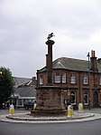
| Queensberry Column |
Dumfries, English Street |
|
NX9723576149 |
55°04′09″N 3°36′39″W / 55.069134°N 3.610822°W / 55.069134; -3.610822 (Queensberry Column) |
Memorial column to 3rd Duke of Queensberry by Robert Adam, 1780[191] |
26173 |
 Upload another image
|
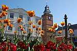
| Midsteeple |
Dumfries, High Street |
|
NX9724076148 |
55°04′09″N 3°36′39″W / 55.069126°N 3.610744°W / 55.069126; -3.610744 (Midsteeple) |
Town house and clock tower built 1707[192] |
26215 |
 Upload another image
|
| The Globe Inn |
Dumfries, High Street |
|
NX9730275974 |
55°04′03″N 3°36′35″W / 55.067576°N 3.609711°W / 55.067576; -3.609711 (The Globe Inn) |
Mid-18th-century inn[193] |
26230 |
 Upload another image
|
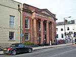
| Former Trades Hall |
Dumfries, Queensberry Square |
|
NX9725176134 |
55°04′08″N 3°36′38″W / 55.069003°N 3.610567°W / 55.069003; -3.610567 (Former Trades Hall) |
Classical hall by Thomas Boyd, 1804[194] |
26234 |
Upload another image
|
| 29 Irish Street and 92 Whitesands |
Dumfries |
|
NX9722975838 |
55°03′59″N 3°36′39″W / 55.066339°N 3.610804°W / 55.066339; -3.610804 (29 Irish Street and 92 Whitesands) |
Earlier 18th-century town house[195] |
26240 |
.jpg) Upload another image
|
| 24 Nith Place |
Dumfries |
|
NX9732475858 |
55°04′00″N 3°36′34″W / 55.066539°N 3.609324°W / 55.066539; -3.609324 (24 Nith Place) |
Earlier 18th-century Baroque town house[196] |
26305 |
|
| St Michael's Church |
Dumfries, St Michael's Street |
|
NX9755275692 |
55°03′54″N 3°36′21″W / 55.065095°N 3.605696°W / 55.065095; -3.605696 (St Michael's Church) |
Mid-18th-century church[197] |
26335 |
 Upload another image
|
| St Michael's Churchyard |
Dumfries, St Michael Street |
|
NX9754575699 |
55°03′55″N 3°36′21″W / 55.065156°N 3.605808°W / 55.065156; -3.605808 (St Michael's Churchyard) |
18th- and 19th-century monuments including Baroque Sharp of Hoddom monument[198] |
26336 |
.jpg) Upload another image
|
| St Michael's Churchyard, Burns' Mausoleum |
Dumfries, St Michael Street |
|
NX9760175690 |
55°03′54″N 3°36′18″W / 55.065087°N 3.604928°W / 55.065087; -3.604928 (St Michael's Churchyard, Burns' Mausoleum) |
Octagonal mausoleum of Robert Burns, by Thomas Hunt, 1815[199] |
26337 |
 Upload another image
See more images
|
| Devorgilla Bridge |
Dumfries, over River Nith |
|
NX9689076053 |
55°04′06″N 3°36′58″W / 55.0682°N 3.616188°W / 55.0682; -3.616188 (Devorgilla Bridge) |
Medieval bridge, rebuilt many times[200] |
26354 |
 Upload another image
See more images
|
| Blair House |
Kirkcudbright, High Street |
|
NX6816051070 |
54°50′13″N 4°03′16″W / 54.837042°N 4.054315°W / 54.837042; -4.054315 (Blair House) |
Early-19th-century town house[201] |
36529 |
|
| Broughton House |
Kirkcudbright, High Street |
|
NX6815151050 |
54°50′13″N 4°03′16″W / 54.83686°N 4.054446°W / 54.83686; -4.054446 (Broughton House) |
Mid-18th-century classical detached house[202] |
36530 |
 Upload another image
See more images
|
| Kirkcudbright Tolbooth and Market Cross |
Kirkcudbright, High Street |
|
NX6806550896 |
54°50′08″N 4°03′21″W / 54.835454°N 4.055714°W / 54.835454; -4.055714 (Kirkcudbright Tolbooth and Market Cross) |
16th-century tolbooth and 17th-century mercat cross[203] |
36542 |
 Upload another image
|
| 66, 68, 70 High Street |
Kirkcudbright |
|
NX6808350883 |
54°50′07″N 4°03′20″W / 54.835342°N 4.055428°W / 54.835342; -4.055428 (66, 68, 70 High Street) |
17th-century terraced houses[204] |
36545 |
|
| 74 High Street and Cannon's Close |
Kirkcudbright |
|
NX6810150869 |
54°50′07″N 4°03′19″W / 54.835221°N 4.055141°W / 54.835221; -4.055141 (74 High Street and Cannon's Close) |
17th-century terraced houses[205] |
36546 |
|
| Langholm Parish Church |
Langholm |
|
NY3615084466 |
55°09′01″N 3°00′12″W / 55.150396°N 3.003426°W / 55.150396; -3.003426 (Langholm Parish Church) |
Large Gothic church by William Burn and David Bryce, 1843[206] |
37137 |
 Upload another image
|
| Lochmaben Parish Church |
Lochmaben |
|
NY0836582268 |
55°07′35″N 3°26′19″W / 55.126283°N 3.438566°W / 55.126283; -3.438566 (Lochmaben Parish Church) |
Gothic church built 1820, in the style of Walter Newall[207] |
37539 |
 Upload another image
|
| Lochmaben Tolbooth |
Lochmaben |
|
NY0818182576 |
55°07′44″N 3°26′30″W / 55.129016°N 3.44155°W / 55.129016; -3.44155 (Lochmaben Tolbooth) |
18th-century tolbooth with 19th-century additions by David Bryce[208] |
37541 |
|
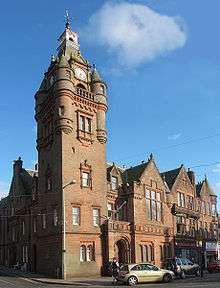
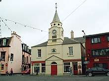
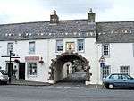
| Lockerbie Town Hall |
Lockerbie |
|
NY1369381645 |
55°07′18″N 3°21′17″W / 55.121644°N 3.354849°W / 55.121644; -3.354849 (Lockerbie Town Hall) |
Scots Baronial town hall by David Bryce, built from 1884[209] |
37579 |
 Upload another image
|
| St Andrew's Parish Church |
Moffat |
|
NT0844305126 |
55°19′54″N 3°26′41″W / 55.33163°N 3.444769°W / 55.33163; -3.444769 (St Andrew's Parish Church) |
Gothic church by John Starforth, 1887[210] |
37881 |
 Upload another image
See more images
|
| Moffat House Hotel |
Moffat |
|
NT0837005369 |
55°20′02″N 3°26′46″W / 55.333799°N 3.445998°W / 55.333799; -3.445998 (Moffat House Hotel) |
Substantial house by John Adam for the Earl of Hopetoun, 1762[211] |
37928 |
 Upload another image
|
| Sidmount Cottage |
Moffat |
|
NT0897105543 |
55°20′08″N 3°26′12″W / 55.335474°N 3.436584°W / 55.335474; -3.436584 (Sidmount Cottage) |
Villa dated 1836[212] |
37935 |
|
| Penninghame Parish Church |
Newton Stewart |
|
NX4096565412 |
54°57′28″N 4°29′07″W / 54.957903°N 4.485267°W / 54.957903; -4.485267 (Penninghame Parish Church) |
Gothic church by William Burn, 1838[213] |
38663 |
 Upload another image
|
| Cree Bridge |
Newton Stewart, over River Cree |
|
NX4115465653 |
54°57′36″N 4°28′57″W / 54.960127°N 4.482452°W / 54.960127; -4.482452 (Cree Bridge) |
Five-arch stone bridge, built 1813 by John Rennie[214] |
38667 |
 Upload another image
|
| Douglas House, former Douglas School |
Newton Stewart, King Street |
|
NX4086266400 |
54°58′00″N 4°29′15″W / 54.96674°N 4.487422°W / 54.96674; -4.487422 (Douglas House, former Douglas School) |
Former school of 1834, by John Henderson[215] |
38672 |
|
| Sanquhar Tolbooth |
Sanquhar |
|
NS7809009913 |
55°22′05″N 3°55′30″W / 55.368028°N 3.925047°W / 55.368028; -3.925047 (Sanquhar Tolbooth) |
Baroque tolbooth by William Adam, 1735[216] |
40540 |
 Upload another image
|
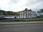
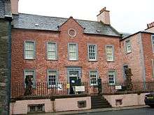
| Stranraer Museum, formerly Old Town Hall |
Stranraer, George Street |
|
NX0594660834 |
54°54′16″N 5°01′42″W / 54.904423°N 5.028312°W / 54.904423; -5.028312 (Stranraer Museum, formerly Old Town Hall) |
18th-century town hall with 19th-century extension[217] |
41745 |
 Upload another image
|
| Stranraer Castle |
Stranraer |
|
NX0609060821 |
54°54′16″N 5°01′34″W / 54.904362°N 5.026061°W / 54.904362; -5.026061 (Stranraer Castle) |
Early-16th-century L-plan tower house, remodelled in the 1980s[218] |
41765 |
 Upload another image
See more images
|
| 53 George Street and entrance to Whithorn Priory |
Whithorn |
|
NX4454840251 |
54°43′59″N 4°24′57″W / 54.73313°N 4.415823°W / 54.73313; -4.415823 (53 George Street and entrance to Whithorn Priory) |
Later 18th-century house with arched pend[219] |
42195 |
 Upload another image
|
| 55–57 (odd nos) George Street |
Whithorn |
|
NX4454040235 |
54°43′59″N 4°24′57″W / 54.732983°N 4.415939°W / 54.732983; -4.415939 (55–57 (odd nos) George Street) |
18th-century houses[220] |
42196 |
|
| 18 and 20 King Street |
Stranraer |
|
NX0581560903 |
54°54′18″N 5°01′49″W / 54.904991°N 5.030399°W / 54.904991; -5.030399 (18 and 20 King Street) |
Early-19th-century bakery and shop[221] |
45230 |
|