List of Category A listed buildings in Renfrewshire
This is a list of Category A listed buildings in the Renfrewshire council area in west-central Scotland.
In Scotland, the term listed building refers to a building or other structure officially designated as being of "special architectural or historic interest".[1] Category A structures are those considered to be "buildings of national or international importance, either architectural or historic, or fine little-altered examples of some particular period, style or building type."[2] Listing was begun by a provision in the Town and Country Planning (Scotland) Act 1947, and the current legislative basis for listing is the Planning (Listed Buildings and Conservation Areas) (Scotland) Act 1997.[3] The authority for listing rests with Historic Scotland, an executive agency of the Scottish Government, which inherited this role from the Scottish Development Department in 1991. Once listed, severe restrictions are imposed on the modifications allowed to a building's structure or its fittings. Listed building consent must be obtained from local authorities prior to any alteration to such a structure.[3] There are approximately 47,400 listed buildings in Scotland, of which around 8% (some 3,800) are Category A.[4]
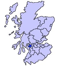
The council area of Renfrewshire covers 261 square kilometres (101 sq mi), and has a population of around 169,800. There are 39 Category A listed buildings in the area.
Listed buildings
.jpg)

.jpg)


.jpg)


.jpg)


See also
Notes
- ↑ Sometimes known as OSGB36, the grid reference (where provided) is based on the British national grid reference system used by the Ordnance Survey.
• "Guide to National Grid". Ordnance Survey. Retrieved 2007-12-12.
• "Get-a-map". Ordnance Survey. Retrieved 2007-12-17. - ↑ The "HB Number" is a unique number assigned to each listed building by Historic Environment Scotland.
References
- ↑ Guide to the Protection of Scotland’s Listed Buildings (PDF). Historic Scotland. 2009. p. 4. ISBN 978-1-84917-013-0. Retrieved 2010-05-05.
- ↑ "What is Listing?". Historic Scotland. Retrieved 2010-05-05.
- 1 2 Scottish Historic Environment Policy (PDF). Historic Scotland. October 2008. pp. 24–25. ISBN 978-1-84917-002-4. Retrieved 2010-05-05.
- ↑ Guide to the Protection of Scotland’s Listed Buildings, p. 17.
- ↑ "Formakin House, By Bishopton: Listed Building Report". Historic Scotland.
- ↑ "Bishopton, Mark Hall Drive, Mark Hall Hotel (Former portion of Erskine Hospital, formerly Erskine House): Listed Building Report". Historic Scotland.
- ↑ "Lochwinnoch Village Church Street Parish Church And Hall: Listed Building Report". Historic Scotland.
- ↑ "Two Monuments Within Houston And Kilellan Church: Listed Building Report". Historic Scotland.
- ↑ "Northbar House Inchinnan: Listed Building Report". Historic Scotland.
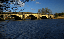
- ↑ "Inchinnan Bridge Over Black Cart Water, (Part In Renfrew Parish): Listed Building Report". Historic Scotland.
- ↑ "Kilbarchan Steeple And Steeple Buildings, Steeple Square, Kilbarchan: Listed Building Report". Historic Scotland.
- ↑ "Weaver's Cottage, The Cross, Kilbarchan: Listed Building Report". Historic Scotland.
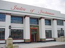
- ↑ "India Of Inchinnan (Dunlop Limited) Office Range: Listed Building Report". Historic Scotland.
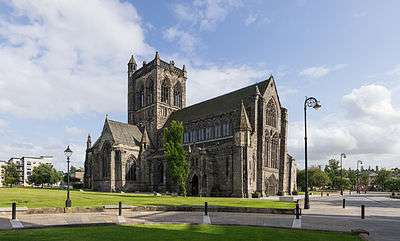
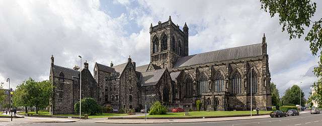
- ↑ "Abbey Close, Paisley Abbey: Listed Building Report". Historic Scotland.
- ↑ "Abbey Close Place Of Paisley: Listed Building Report". Historic Scotland.
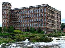
- ↑ "Anchor Mills, Former Domestic Finishing Mill: Listed Building Report". Historic Scotland.
- ↑ "Anchor Mills, Mile End Mill: Listed Building Report". Historic Scotland.
- ↑ "Blackhall Railway Viaduct Over White Cart Water: Listed Building Report". Historic Scotland.
- ↑ "Causeyside Street Russell Institute: Listed Building Report". Historic Scotland.
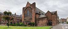
- ↑ "Church Hill And Oakshaw Street, High Church: Listed Building Report". Historic Scotland.
- ↑ "Church Hill Christian Social Action Centre: Listed Building Report". Historic Scotland.
- ↑ "The Cross, War Memorial: Listed Building Report". Historic Scotland.
- ↑ "Gauze Street George A Clark Town Hall: Listed Building Report". Historic Scotland.
- ↑ "7 Gilmour Street Clydesdale Bank: Listed Building Report". Historic Scotland.
- ↑ "Gordon Street / Johnston Street, St Matthew's Church Including Railings: Listed Building Report". Historic Scotland.
- ↑ "Hawkhead Road, Hawkhead Hospital, Wards 7 And 8: Listed Building Report". Historic Scotland.
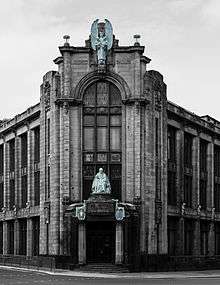
- ↑ "High Street, Museum, Art Gallery And Library: Listed Building Report". Historic Scotland.
- ↑ "High Street, Coats Memorial Church: Listed Building Report". Historic Scotland.
- ↑ "Fountain Gardens Love Street Fountain: Listed Building Report". Historic Scotland.
- ↑ "Moredun Road Crosbie: Listed Building Report". Historic Scotland.
- ↑ "7 New Street The Bull Inn: Listed Building Report". Historic Scotland.
- ↑ "Oakshawhead Former John Neilson Institution And Entrance Lodge: Listed Building Report". Historic Scotland.
- ↑ "49 Oakshaw Street Coats Observatory: Listed Building Report". Historic Scotland.
- ↑ "St James Street Sheriff Court House: Listed Building Report". Historic Scotland.
- ↑ "Two Monuments Within Renfrew Old Parish Church, High Street: Listed Building Report". Historic Scotland.
- ↑ "White Cart Bridge, Inchinnan Road, Over Part Of White Cart Water: Listed Building Report". Historic Scotland.
- ↑ "Rolling Lift Bridge Over White Cart Water: Listed Building Report". Historic Scotland.
- ↑ "The Cross, Renfrew Town Hall: Listed Building Report". Historic Scotland.
- ↑ "Penilee Road, Paisley Grammar School, Penilee Sports Pavilion: Listed Building Report". Historic Scotland.
External links
![]()