Arâches-la-Frasse
| Arâches-la-Frasse | ||
|---|---|---|
| Commune | ||
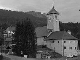 The church in Arâches-la-Frasse | ||
| ||
 Arâches-la-Frasse Location within Auvergne-Rhône-Alpes region  Arâches-la-Frasse | ||
| Coordinates: 46°02′39″N 6°37′56″E / 46.0442°N 6.6322°ECoordinates: 46°02′39″N 6°37′56″E / 46.0442°N 6.6322°E | ||
| Country | France | |
| Region | Auvergne-Rhône-Alpes | |
| Department | Haute-Savoie | |
| Arrondissement | Bonneville | |
| Canton | Sallanches | |
| Government | ||
| • Mayor (2014–2020) | Marc Iochum | |
| Area1 | 37.69 km2 (14.55 sq mi) | |
| Population (2014)2 | 1,909 | |
| • Density | 51/km2 (130/sq mi) | |
| Time zone | UTC+1 (CET) | |
| • Summer (DST) | UTC+2 (CEST) | |
| INSEE/Postal code | 74014 /74300 | |
| Elevation | 560–2,466 m (1,837–8,091 ft) | |
|
1 French Land Register data, which excludes lakes, ponds, glaciers > 1 km2 (0.386 sq mi or 247 acres) and river estuaries. 2 Population without double counting: residents of multiple communes (e.g., students and military personnel) only counted once. | ||

Arâches-la-Frasse is commune in the Haute-Savoie department in the Auvergne-Rhône-Alpes region in south-eastern France.
Situated in the northern French Alps, the commune sits on a large sunny plateau overlooking the Arve Valley southeast of the town of Cluses.
It is part of the canton of Sallanches. The main villages in the commune are Arâches, Les Carroz, and La Frasse.
Les Carroz

Until the 1930s the village of Les Carroz was a simple farming hamlet with only a few houses. It is now developing into the nearest large ski resort to Geneva. By 1981 Les Carroz had been linked to the nearby ski villages of Samoëns, Morillon and Sixt-Fer-à-Cheval, and the resort of Flaine, developed in the 1960s. The Grand-Massif ski area had been born. The gondola and chairlift in Les Carroz can take skiers straight up to the extensive skiing in the Grand Massif.[1]
Gallery
 Church
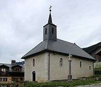 Chapel
 Mission cross
 War memorial
 Fountain
See also
References
External links
| Wikimedia Commons has media related to Arâches-la-Frasse. |
- Les Carroz webcam: http://www.grandmassif.co.uk