Saktigarh, Bardhaman
| Saktigarh শক্তিগড় | |
|---|---|
| Village | |
 Saktigarh Location in West Bengal, India | |
| Coordinates: 23°13′N 87°58′E / 23.21°N 87.96°ECoordinates: 23°13′N 87°58′E / 23.21°N 87.96°E | |
| Country |
|
| State | West Bengal |
| District | Purba Bardhaman |
| Elevation | 23 m (75 ft) |
| Population (2011) | |
| • Total | 8,432 |
| Languages | |
| • Official | Bengali, English |
| Time zone | UTC+5:30 (IST) |
| PIN | 713149 |
| Telephone code | 91 342 |
| Vehicle registration | WB 42 |
| Website |
bardhaman |
Saktigarh is a village in Burdwan II CD Block in Bardhaman Sadar North subdivision of Purba Bardhaman district in the Indian state of West Bengal.
Geography
Saktigarh is located at 23°13′N 87°58′E / 23.21°N 87.96°E
Saktigarh is part of the Bardhaman Plain, the central plain area of the district. The area is surrounded by the Bhagirathi on the east, the Ajay on the north-west and the Damodar on the west and south. Old river channels and small creeks found in the region dry up in the dry season, but the Bardhaman Plains are sometimes subject to heavy floods during the rainy season. The region has recent alluvial soils.[1]
Demographics
As per the 2011 Census of India Saktigarh had a total population of 8,432, of which 4,252 (50%) were males and 4,180 (50%) were females. Population below 6 years was 913. The total number of literates in Saktigar was 5,730 (76.21% of the population over 6 years).[2]
Transport
Saktigarh railway station is the railway junction of the Howrah-Bardhaman chord and main lines. It is 83 kilometres (52 mi) from Howrah Station via chord and 96 kilometres (60 mi) via main line. It is 12 kilometres (7.5 mi) from Bardhaman.[3] It is part of Kolkata Suburban Railway system.
It is located on Grand Trunk Road and the newly constructed NH 19 (old numbering NH 2) bypasses the town. There is a regular bus-service between Barsul, Memari, Jamalpur to Bardhaman via Saktigarh. The service is in high demand and many people prefer this route to railways while coming here from Bardhaman.
Culture
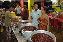
Saktigarh is famous for the sweet langcha. There are innumerable shops selling those dark-red sweets along NH 19.[4]
References
- ↑ "Census of India 2011, West Bengal: District Census Handbook, Barddhaman" (PDF). Physiography, pages 13-14. Directorate of Census Operations, West Bengal. Retrieved 23 January 2017.
- ↑ "2011 Census – Primary Census Abstract Data Tables". West Bengal – District-wise. Registrar General and Census Commissioner, India. Retrieved 20 February 2017.
- ↑ Eastern Railway local time table
- ↑ "Sweet spot: why everyone must pause in langcha land on the highway". The Telegraph, 21 June 2012. Retrieved 24 February 2017.
Cities, towns and locations in Purba Bardhaman district | |||||||||
|---|---|---|---|---|---|---|---|---|---|
| Cities, municipal and census towns |
| ||||||||
| Locations other than cities and towns |
| ||||||||
| Related topics |
| ||||||||