Lambert's Bay
| Lambert's Bay Lambertsbaai | |
|---|---|
 Lambert's Bay | |
 Lambert's Bay  Lambert's Bay Lambert's Bay (South Africa)  Lambert's Bay Lambert's Bay (Africa) | |
| Coordinates: 32°5′S 18°18′E / 32.083°S 18.300°ECoordinates: 32°5′S 18°18′E / 32.083°S 18.300°E | |
| Country | South Africa |
| Province | Western Cape |
| District | West Coast |
| Municipality | Cederberg |
| Area[1] | |
| • Total | 45.73 km2 (17.66 sq mi) |
| Population (2011)[1] | |
| • Total | 6,120 |
| • Density | 130/km2 (350/sq mi) |
| Racial makeup (2011)[1] | |
| • Black African | 9.0% |
| • Coloured | 74.5% |
| • Indian/Asian | 0.2% |
| • White | 15.9% |
| • Other | 0.4% |
| First languages (2011)[1] | |
| • Afrikaans | 90.9% |
| • Xhosa | 5.8% |
| • English | 1.7% |
| • Other | 1.6% |
| Time zone | UTC+2 (SAST) |
| Postal code (street) | 8130 |
| PO box | 8130 |
| Area code | 027 |
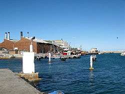
Lambert's Bay is a small fishing town in the Western Cape province of South Africa situated 280 kilometres (170 mi) north of Cape Town. It is part of the Cederberg Municipality.
The coast town has been proclaimed 'the Diamond of the West Coast' because of its white beaches, wildlife and lobsters. Although primarily a fishing town it has become a significant tourist attraction on the West Coast due to its moderate all-year climate.
The town also hosts the Crayfish Festival.[2]
Birding
- Bird Island Nature Reserve - The nesting and breeding ground of thousands of Cape gannets, penguins and other bird species can be reached by walking on a breakwater wall.
See also
- Mussel Point, a prehistoric shell midden near Lamberts Bay
History
Lambert's Bay is named after Admiral Lambert of the British Navy who did a marine survey of the bay between 1826 and 1840.
In 1887 Mr Stephan bought the commercial buildings and built the hotel in 1888. Lambert's Bay was used as a lay-up for British warships during the war of 1900-1902 and in 1901 HMS Sybille was wrecked opposite Steenbokfontein.
The first crayfish factory was started by Mr Lindström in 1918.
References
- 1 2 3 4 "Main Place Lambert's Bay". Census 2011.
- ↑ www.kreeffees.co.za
| Wikimedia Commons has media related to Lamberts Bay. |
Municipalities and communities of West Coast District Municipality, Western Cape | ||
|---|---|---|
District seat: Moorreesburg | ||
| Matzikama | .svg.png) | |
| Cederberg | ||
| Bergrivier | ||
| Saldanha Bay | ||
| Swartland | ||