Laird, Saskatchewan
| Laird | |
|---|---|
| Village | |
| Village of Laird | |
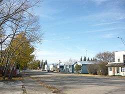 Main Street, Laird | |
 Location of Laird in Saskatchewan  Laird, Saskatchewan (Canada) | |
| Coordinates: 52°42′43″N 106°35′24″W / 52.712°N 106.59°WCoordinates: 52°42′43″N 106°35′24″W / 52.712°N 106.59°W | |
| Country |
|
| Province |
|
| Region | Central |
| Census division | 15 |
| Rural Municipality | Rosthern No. 403 |
| Government | |
| • Type | Municipal |
| • Governing body | Laird Village Council |
| • Mayor | Chris Harris |
| Area | |
| • Total | 1.29 km2 (0.50 sq mi) |
| Population (2016) | |
| • Total | 267 |
| • Density | 207.6/km2 (538/sq mi) |
| Time zone | UTC-6 (CST) |
| Postal code | S0K 2H0 |
| Area code(s) | 306 |
| Highways |
|
| Railways | (Pulled) |
| [1][2][3][4] | |
Laird is a village within the Rural Municipality of Rosthern No. 403, in the province of Saskatchewan, Canada. Laird is located in the Saskatchewan River Valley. The village is named after David Laird, Lieutenant Governor of the Northwest Territories.[5] Laird had a population of 267 in the 2016 Canada Census, (a -7.0% decrease from 287 in the 2011 Canada Census).
Demographics
| Canada census – Laird, Saskatchewan community profile | |||
|---|---|---|---|
| 2016 | 2011 | 2006 | |
| Population: | 267 (-7.0% from 2011) | 287 (+38.6% from 2006) | 207 (-12.3% from 2001) |
| Land area: | 1.29 km2 (0.50 sq mi) | 1.29 km2 (0.50 sq mi) | 1.29 km2 (0.50 sq mi) |
| Population density: | 207.6/km2 (538/sq mi) | 223.2/km2 (578/sq mi) | 161.0/km2 (417/sq mi) |
| Median age: | 45.2 (M: 46.8, F: 42.5) | 42.9 (M: 43.2, F: 42.8) | |
| Total private dwellings: | 118 | 114 | 103 |
| Median household income: | $NA | $NA | |
| References: 2016[6] 2011[7] 2006[8] earlier[9] | |||
See also
References
- ↑ National Archives, Archivia Net, Post Offices and Postmasters, archived from the original on 2006-10-06
- ↑ Government of Saskatchewan, MRD Home, Municipal Directory System, archived from the original on November 21, 2008
- ↑ Canadian Textiles Institute. (2005), CTI Determine your provincial constituency, archived from the original on 2007-09-11
- ↑ Commissioner of Canada Elections, Chief Electoral Officer of Canada (2005), Elections Canada On-line, archived from the original on 2007-04-21
- ↑ http://ca.epodunk.com/profiles/saskatchewan/laird/2001211.html
- ↑ "2016 Community Profiles". Canada 2016 Census. Statistics Canada. February 21, 2017. Retrieved 2017-03-15.
- ↑ "2011 Community Profiles". Canada 2011 Census. Statistics Canada. July 5, 2013. Retrieved 2012-04-15.
- ↑ "2006 Community Profiles". Canada 2006 Census. Statistics Canada. March 30, 2011. Retrieved 2012-04-15.
- ↑ "2001 Community Profiles". Canada 2001 Census. Statistics Canada. February 17, 2012.
External links
- Saskatchewan City & Town Maps
- Saskatchewan Gen Web - One Room School Project
- Post Offices and Postmasters - ArchiviaNet - Library and Archives Canada
- Saskatchewan Gen Web Region
- Online Historical Map Digitization Project
- GeoNames Query
- 2006 Community Profiles
Places adjacent to Laird, Saskatchewan | |
|---|---|
| Subdivisions | |
|---|---|
| Communities | |
| Cities | |
| Topics |
|
| |
| Cities | 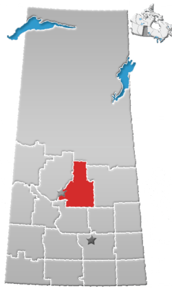 | |
|---|---|---|
| Towns | ||
| Villages | ||
| Resort villages | ||
| Rural municipalities | ||
| Unincorporated communities | ||
This article is issued from
Wikipedia.
The text is licensed under Creative Commons - Attribution - Sharealike.
Additional terms may apply for the media files.