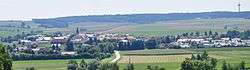
Laberweinting
| Laberweinting | ||
|---|---|---|
 | ||
| ||
 Laberweinting Location of Laberweinting within Straubing-Bogen district 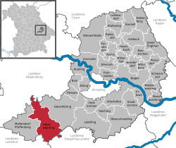 | ||
| Coordinates: 48°48′N 12°19′E / 48.800°N 12.317°ECoordinates: 48°48′N 12°19′E / 48.800°N 12.317°E | ||
| Country | Germany | |
| State | Bavaria | |
| Admin. region | Niederbayern | |
| District | Straubing-Bogen | |
| Government | ||
| • Mayor | Johann Grau (CSU) | |
| Area | ||
| • Total | 76.32 km2 (29.47 sq mi) | |
| Elevation | 369 m (1,211 ft) | |
| Population (2017-12-31)[1] | ||
| • Total | 3,387 | |
| • Density | 44/km2 (110/sq mi) | |
| Time zone | CET/CEST (UTC+1/+2) | |
| Postal codes | 84082 | |
| Dialling codes | 08772 | |
| Vehicle registration | SR | |
| Website | www.laberweinting.de | |

Laberweinting is a municipality in the district of Straubing-Bogen in Bavaria, Germany.
Geography
The Große Laaber and the Kleine Laber, the Bayerbach and the Grafentraubach flow through the Laberweinting.
Subdivisions
The municipality Laberweinting consists of 31 villages[2]
|
|
|
|
Main sights
- Schloss Grafentraubach (built 1507)
- Church of Saint Martin (built 1679/1681)
- Church of Saint Nikolaus (built 1869)
See also
References
External links
![]()
This article is issued from
Wikipedia.
The text is licensed under Creative Commons - Attribution - Sharealike.
Additional terms may apply for the media files.