Wiesenfelden
| Wiesenfelden | ||
|---|---|---|
 Church of the Assumption of the Virgin Mary | ||
| ||
 Wiesenfelden Location of Wiesenfelden within Straubing-Bogen district 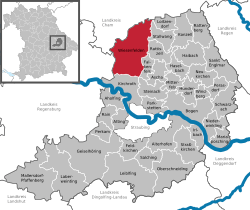 | ||
| Coordinates: 49°2′N 12°32′E / 49.033°N 12.533°ECoordinates: 49°2′N 12°32′E / 49.033°N 12.533°E | ||
| Country | Germany | |
| State | Bavaria | |
| Admin. region | Niederbayern | |
| District | Straubing-Bogen | |
| Government | ||
| • Mayor | Anton Drexler (CSU) | |
| Area | ||
| • Total | 78.24 km2 (30.21 sq mi) | |
| Elevation | 610 m (2,000 ft) | |
| Population (2017-12-31)[1] | ||
| • Total | 3,750 | |
| • Density | 48/km2 (120/sq mi) | |
| Time zone | CET/CEST (UTC+1/+2) | |
| Postal codes | 94344 | |
| Dialling codes | 09966 | |
| Vehicle registration | SR | |
| Website | www.wiesenfelden.de | |

Wiesenfelden is a municipality in the district of Straubing-Bogen in Bavaria, Germany.
References
- ↑ "Fortschreibung des Bevölkerungsstandes". Bayerisches Landesamt für Statistik und Datenverarbeitung (in German). September 2018.
This article is issued from
Wikipedia.
The text is licensed under Creative Commons - Attribution - Sharealike.
Additional terms may apply for the media files.