La Unión Province, Peru
| La Unión | |
|---|---|
| Province | |
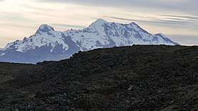 Solimana volcano, La Unión Province | |
 Location of La Unión in the Arequipa Region | |
| Country | Peru |
| Region | Arequipa |
| Capital | Cotahuasi |
| Area | |
| • Total | 4,746.4 km2 (1,832.6 sq mi) |
| Elevation | 2,388 m (7,835 ft) |
| Population | |
| • Total | 15,662 |
| • Density | 3.3/km2 (8.5/sq mi) |
| UBIGEO | 0408 |
| Website | www.municotahuasi.gob.pe |
La Unión is a province of the Arequipa Region in Peru. Its seat is Cotahuasi.
Geography
The Huanzo mountain range traverses the province. One of the highest peaks of the province is Solimana at 6,093 metres (19,990 ft). Other mountains are listed below:[1]
- Allqa Q'awa
- Allqa Walusa
- Anka Phawa (Cond.-La Unión)
- Anka Phawa (Puyca)
- Anqasi
- Aqu Suntu
- Aqu Suntu (Chullumpi)
- Challwa Q'asa
- Chawpi Chawpi
- Chullumpi
- Chunta
- Chunta Pata
- Chhijmuni
- Ch'uwañuma
- Hatun Pata
- Hatun Sisiwa
- Inti Utka
- Janq'u Q'awa
- Kimsa Chata
- Khirki Urqu
- Khuchi Pata
- Lujmani
- Lunq'u
- Llamuqa
- Llimphiq
- Kuntur K'uchu
- Kuntur Sayana
- Kunturi (Cond.-La Unión)
- Kunturi (Ikmaqucha)
- Kunturi (La Unión)
- Kunturillu
- Minasniyuq
- Paxsi
- Pichaqani
- Pilluni
- Pirqasqa
- Pisti Q'asa
- Puka Ranra
- Puka Suntu
- Puka Urqu
- P'umpu Q'asa
- Qarwa K'uchu
- Qarwa Urqu
- Qillqata
- Kimsa Qaqa
- Qullpa
- Qullpa K'uchu
- Q'illu Urqu
- Rumi Urqu
- Saraqutu
- Sullu Marka
- Sunqu Urqu
- Suphu Marka
- Taruja Marka
- Taypi Q'awa
- Tintaya
- Thujsa
- T'ula Qaqa
- Uma Q'asa
- Waych'awi
- Wachu Willka
- Waraqu
- Wayrawiri
- Wayta Urqu
- Waytani
- Wila Quta
- Wiñaw
- Yana Yana
- Yuraq Apachita
- Yuraq Punta
- Yuraq Rumi
- Yuraq Urqu
Political division
The province is divided into eleven districts which are
- Alca
- Charcana
- Cotahuasi (Province Seat)
- Huaynacotas
- Pampamarca
- Puyca
- Quechualla
- Sayla
- Tauria
- Tomepampa
- Toro
Ethnic groups
The people in the province are mainly indigenous citizens of Quechua descent. Quechua is the language which the majority of the population (59.18%) learnt to speak in childhood, 40.06% of the residents started speaking using the Spanish language (2007 Peru Census).[2]
See also
Sources
- ↑ escale.minedu.gob.pe - UGEL map of the Chumbivilcas Province (Cusco Region)
- ↑ inei.gob.pe Archived 2013-01-27 at the Wayback Machine. INEI, Peru, Censos Nacionales 2007
External links
- (in Spanish) Official website
- El Portal de Cotahuasi Spanish
- Cotahuasiweb English
| |
|---|---|
Coordinates: 15°03′34″S 72°41′28″W / 15.059567°S 72.691083°W
This article is issued from
Wikipedia.
The text is licensed under Creative Commons - Attribution - Sharealike.
Additional terms may apply for the media files.