Kostelec u Křížků
| Kostelec u Křížků | |
|---|---|
| Municipality and village | |
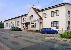 Kostelec u Křížků, restaurant | |
| Country |
|
| Region | Central Bohemian Region |
| District | Prague-East District |
| Area | |
| • Total | 1.6 sq mi (4.1 km2) |
| Elevation | 1,348 ft (411 m) |
| Population (2012) | |
| • Total | 583 |
| Time zone | UTC+1 (CET) |
| • Summer (DST) | UTC+2 (CEST) |
| Postcode | 251 68 |
Kostelec u Křížků is a village and municipality in Prague-East District in the Central Bohemian Region of the Czech Republic. The municipality covers an area of 4.1 square kilometres (1.6 sq mi) and as of 2010 it had a population of 581. First written notice about the village is from year 922.
Gallery
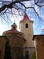 Rotunda of St. Martin
- Local restaurant
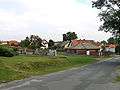 West part
References
- This article was initially translated from the Czech Wikipedia.
| Wikimedia Commons has media related to Kostelec u Křížků. |
This article is issued from
Wikipedia.
The text is licensed under Creative Commons - Attribution - Sharealike.
Additional terms may apply for the media files.