Koro Toro Airport
| Koro-Toro Airport | |||||||||||
|---|---|---|---|---|---|---|---|---|---|---|---|
| Summary | |||||||||||
| Airport type | Public | ||||||||||
| Serves | Koro-Toro, Chad | ||||||||||
| Elevation AMSL | 243 m / 797 ft | ||||||||||
| Coordinates | 16°03′N 018°29′E / 16.050°N 18.483°ECoordinates: 16°03′N 018°29′E / 16.050°N 18.483°E | ||||||||||
| Map | |||||||||||
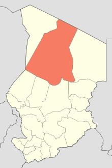 Koro-Toro Location in Chad (Borkou region highlighted) | |||||||||||
| Runways | |||||||||||
| |||||||||||
Koro-Toro Airport is an airport serving Koro-Toro, located in the Borkou region in Chad.
Facilities
The airport resides at an elevation of 243 metres (797 ft) above mean sea level. It has one runway designated 04/22 with a clay and sand surface measuring 1,000 by 30 metres (3,281 ft × 98 ft).[1]
References
- 1 2 "AD 2-7-01: Koro-Toro" (PDF). Index of aerodromes in Chad. AIS ASECNA. 28 July 2011. External link in
|publisher=(help)
This article is issued from
Wikipedia.
The text is licensed under Creative Commons - Attribution - Sharealike.
Additional terms may apply for the media files.