Borkou (region)
Coordinates: 17°55′00″N 19°07′00″E / 17.9167°N 19.1167°E
| Borkou بركو | |
|---|---|
| Region | |
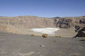 Inner crater of Emi Koussi, highest mountain in Chad, located in Borkou | |
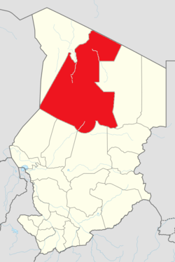 Map of Chad showing the Borkou region | |
| Country | Chad |
| Departments | 2 |
| Sub-prefectures | 4 |
| Region | 2012 |
| Capital | Faya-Largeau |
| Government | |
| • Governor | Erdibou Ramadan (2008) |
| Population (2009) | |
| • Total | 97,251 |
The Borkou region (Arabic: بركو) is a region of Chad which was created in 2008 from the Borkou department of the former Borkou-Ennedi-Tibesti region. Its capital is Faya-Largeau.
Per the census of 2009, the population of the region was 97,251, 46.6% females. The number of households was 16,191: 10,584 in rural areas and 5,607 in urban areas. The number of nomads in the region was 8,221, 2.10 per cent of the population. The sex ratio was 114.00 females for every hundred males. The area is inhabited by the Gouran Kamaya, Donza and Anakazza are ethnic groups of northern Chad.[1]
Demographics
Per the census of 2009, the population of the region was 97,251, 46.6% female. The average size of household as of 2009 is 6.00: 6.00 in rural households and 5.80 in urban areas. The total number of households was 16,191: 10,584 in rural areas and 5,607 in urban areas. The number of nomads in the region was 8,221, 2.1% of the population. There were 96,459 people residing in private households. There were 47,285 above 18 years of ages: 24,775 male and 22,510 female. The sex ratio was 114.00 females for every hundred males. There were 89,030 sedantary staff, 0.80 of the total population.[2] The Head Post Office of the region is located in the capital, Faya-Largeau. As of 2015, internet and telephone were limited and post was the primary mode of communication.[3]
Geography
Borkou is located in the Sahara, and has parts of the Tibesti Mountains in its north. The highest point in Chad, Emi Koussi, is located in Borkou. To the north of Borkou is Libya, and part of its northern territory lies on the Aouzou Strip, an area of land disputed between the two countries. The capital, Faya-Largeau, is located in the central part of the region.[4]
Administration
Chad became independent in 1961 from the French Colonial Empire. On account of ensuing political instability and local civil wars, it continued as a one party democracy till 1991, while other parties were also allowed. All the powers rested centrally with the President.[5] As a part of decentralization in February 2003, the country is administratively split into regions, departments, municipalities and rural communities. The prefectures which were originally 14 in number were re-designated in 17 regions. The regions are administered by Governors appointed by the President. The Prefects, who originally held the responsibility of the 14 prefects, still retained the titles and were responsible for the administration of smaller departments in each region. The members of local assemblies are elected every six years, while the executive organs are elected every three years.[6] As of 2016, there are totally 23 regions in Chad, which are divided based on population and administrative convenience. The Borkou region is divided into two departments, namely, Borkou (capital Faya-Largeau) and Borkou Yala (capital Kirdimi, also called Kirdi).[7]
References
- ↑ "Ordonnance n° 002/PR/08 portant restructuration de certaines" (in French). collectivités territoriales décentralisées. Retrieved 20 November 2016.
- ↑ "Census of Chad". National Institute of Statistical, Economic and Demographic Studies, Chad. 2009. Archived from the original on 21 November 2016. Retrieved 17 November 2016.
- ↑ Falola, Toyin; Jean-Jacques, Daniel (2015). Africa: An Encyclopedia of Culture and Society [3 volumes]: An Encyclopedia of Culture and Society. ABC-CLIO. p. 251. ISBN 9781598846669.
- ↑ "Borkou | region, Chad". Encyclopedia Britannica. Retrieved 2017-05-31.
- ↑ "Chad profile - Timeline". BBC. 2 August 2016. Retrieved 20 November 2016.
- ↑ Republic of Chad Public Administration and Country profile (PDF) (Report). Department of Economic and Social Affairs (DESA), United Nations. 2004. p. 9. Retrieved 17 November 2016.
- ↑ Chad district map (PDF) (Report). Department of Field Support,Cartographic Section, United Nations. Retrieved 20 November 2016.
External links
| ||