Koforidua
| Koforidua City of Koforidua | ||
|---|---|---|
| City | ||
| ||
| Nickname(s): Kof Town | ||
 Koforidua Location of Koforidua in Eastern region, Ghana | ||
| Coordinates: 6°06′N 0°16′W / 6.100°N 0.267°W | ||
| Country |
| |
| Region | Eastern Region | |
| District | New-Juaben Municipal | |
| Elevation | 238 m (781 ft) | |
| Population (2012) | ||
| • Total | 127,334[1] | |
| Time zone | GMT | |
| • Summer (DST) | GMT | |
| Area code(s) | 034 | |
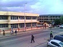
Koforidua, also popularly known as K-dua or kof town , is a city and capital of Eastern Region in south Ghana. The city was founded in 1875 Koforidua has a settlement central city population of 127,334 people in 2012.[1]
Koforidua serves as a commercial centre for the Eastern region and New-Juaben Municipal District. The city is home to many businesses, with the exception of heavy duty industries, The city is home to intravenous infusion Ltd one of the oldest pharmaceutical companies in Ghana and west Africa , a leading producer of injections and drips .The company is listed on the Ghana Stock exchange and was registered in 1969. All Nations University a private University based in the city has currently placed Ghana on the world map of space technology , the University is the first to develop a satellite in West Africa ,the satellite code named Ghansat 1 was handed over to the JAXA the Japanese space agency and subsequently handed over to The NASA in US to be launched in 2017 . The city is home to many Government Departments and Ministries at Regional level. The recent construction of the four-lane highway road linking The Koforidua Technical University and Koforidua to Oyoko brings commerce to the city. The highway also serves as a valid alternative route to reach Kumasi.Due to the concentration of secretarial and commercial schools such as Moses school of Accountancy ,Solomon Commercial school etc in the 1940's to l950's and 1960's,which was very rare in most Ghanaian cities it drew a lot of beautiful ladies into the city ,hence gaining the accolade Koforidua flowers as the beauty of the ladies were compared to flowers by men who visit the city in the olden days. The city's roads are installed with traffic signals and easily links the central business district to the suburbs.The city has many Hotels ranging from 4 star to budget guest facilities.
Etymology
Oral tradition has it that Koforidua owes its name to an Akan man, Kofi Ofori, who had built his hut under a huge mahogany tree. This tree provided shelter for weary farmers who were returning from their farms after a hard day's work. Over time, it became common for the farmers to say that they were going to rest under Kofi Ofori's tree. In Akan, the south country's native language, the word for tree is "dua". An amalgamation of Kofi Ofori's name and tree, therefore, becomes "Koforidua." Ladies from Koforidua are popularly known as Koforidua Flowers
History
Koforidua was founded in 1875 by Akan migrants from Asanteman. The completion in 1923 of the Kumasi railway saw Koforidua become an important road and rail junction. Koforidua is one of the country's oldest cocoa-producing centres. It is also noted today for its weekly Thursday bead market,[2] which draws bead buyers and sellers from all over the Eastern region.
Legend about Koforidua
Legend has it that, the Obuotabiri mountain found in New Juabeng, was the home of the gods and protected the people. It was believed to be inhabited by dwarfs and thus was considered the soul of the New Juabeng traditional area. All the townsfolk have great reverence for the mountain: OBUOTABIRI - the rock of Tabiri.
Geography and climate

The New Juaben Municipality falls within the Eastern Region of South Ghana. The municipality covers an estimated area of 110 square kilometres, constituting 0.57% of the total land area of the Eastern Region.[3] The municipality has 48 electoral areas.
Koforidua has an annual rainfall ranging from 50 – 120 inches and 20 – 32 Celsius mean annual temperatures.
The New-Juaben municipality shares boundaries with East-Akim Municipality to the northeast, Akwapim North District to the east and south, and Suhum-Kraboa-Coaltar District to the west. The city of Koforidua (New Juabeng) is made up of several neighbourhoods and settlements, including Effiduase, Asokore, Oyoko, Jumapo, Suhyen, Dansuagya, Betom, and Srodae. Koforidua is two hours by road from Accra.
| Climate data for Koforidua | |||||||||||||
|---|---|---|---|---|---|---|---|---|---|---|---|---|---|
| Month | Jan | Feb | Mar | Apr | May | Jun | Jul | Aug | Sep | Oct | Nov | Dec | Year |
| Average high °C (°F) | 32 (90) |
32 (90) |
33 (92) |
32 (89) |
32 (90) |
29 (85) |
28 (82) |
28 (82) |
28 (82) |
30 (86) |
32 (89) |
31 (88) |
31 (88) |
| Average low °C (°F) | 24 (75) |
24 (75) |
26 (78) |
24 (76) |
25 (77) |
23 (73) |
23 (73) |
23 (73) |
22 (72) |
23 (73) |
23 (73) |
23 (73) |
23 (74) |
| Average precipitation mm (inches) | 8 (0.3) |
25 (1.0) |
51 (2.0) |
102 (4.0) |
127 (5.0) |
152 (6.0) |
76 (3.0) |
25 (1.0) |
76 (3.0) |
76 (3.0) |
25 (1.0) |
8 (0.3) |
752 (29.6) |
| Source: Myweather2.com[4] | |||||||||||||
Demographics
Presently the city's population is 127,334 people[1] and is dominated by Akans. The 'Akwantukese' (The Big Journey Festival) is celebrated yearly to mark the movement of the inhabitants of Koforidua's ancestors from 'Asanteman' to their present location of Koforidua.
Economy

Industries
The city is home to one of Ghana's oldest pharmaceutical Manufacturing companies i.e. Intravenous infusion Ltd which manufactures drips and injections for the West African Market . Other Industrial activities of Koforidua include textiles, crafts, soap, carpentry and joinery, traditional medicine, pottery and ceramics, and the production of alcoholic and non-alcoholic beverages.[5][6]
Financial Services
Koforidua is also home to many financial services companies ranging from Universal Banks, Micro-finance, Rural Banks and Savings and Loans Companies to Insurance Companies.
Agriculture
The city currently depends mainly on Government Administration , Retailing ,hospitality , commercial and Education services . With inhabitants in the Cornubations(Outskirt surrounding communities) engaging in some form of subsistence farming.
Cocoa production
Koforidua produces cocoa. However, as cocoa production has moved westward to the Ashanti Region and Brong-Ahafo Region areas of virgin soil, Koforidua has become increasingly dependent upon its commercial and business administrative functions. The city of Koforidua has only small-medium scale industries today.[5]

Tourism

Koforidua's predominant tourism attractions include such natural features as Obuo Tabri Mountain, which is considered sacred. Nearby is Akosombo Dam, which holds Lake Volta, the world's largest man-made lake.
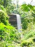
Waterfalls in the area, such as Akaa Falls and Boti Falls, and the Umbrella Rock attract tourists to the Eastern region. Even though such tourist sites are functioning all year round, tourists are at times encouraged to visit the place at certain times of the year, especially during the rainy seasons. At such times, the Boti Falls in particular is fully at its peak beauty and very interesting to visit.
Education

Koforidua remains a major hub of education in Ghana. It is home to many basic schools and a number of prominent senior high schools in the country. In 2012, one of its schools; Pope John Senior High School and Minor Seminary, was ranked 9th of the over 200 senior high schools in Ghana. The city also has a Technical University (Koforidua Technical University) and two private universities (All Nations University College) and (Ghana telecom University College).

and has campuses for other national Universities , the city also have Teacher training college ,Nursing and Midwifery College and other educational institutions
There are other High Schools in Koforidua. These include Pope John Senior High and Junior Seminary (Pojoss),Oti Boateng Senior High School (Oboss), Koforidua Secondary Technical Senior High School(K.S.T.S),Pentecost Senior High School(Pensec),Ghana Senior High School (Ghanass). New Juabeng Senior High School (Njuasco), New Juabeng College of Commerce (Njuacoco) , Normal Technical Institute amongst other Private High Schools. These senior high schools train students from all over the Ghana, preparing them for the West African Senior School Certificate Examination (WASSCE). Passing WASSCE is essential to getting into Universities and other Tertiary Institutions in Ghana.
See also
References
- 1 2 3 "World Gazetteer online". World-gazetteer.com. Archived from the original on 11 January 2012.
- ↑ Mensah, Henry. "Experience Koforidua". Ghana Web. Retrieved 19 April 2018.
- ↑ "New-Juaben Municipal". New Juaben Municipal. Archived from the original on 11 February 2010. Retrieved 25 January 2010.
- ↑ "Koforidua Weather Averages". Myweather2. 2013. Retrieved 20 June 2013.
- 1 2 "Agricultural sector". New Juaben Municipal. Archived from the original on 11 February 2010. Retrieved 25 January 2010.
- ↑ Latest Ghana News. Vibe Ghana
External links
| Wikimedia Commons has media related to Koforidua. |

