Greater Accra Region
| Greater Accra Region | ||
|---|---|---|
| Region | ||
| ||
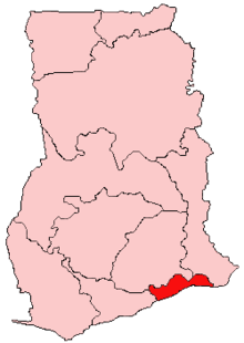 Location of Greater Accra Region in Ghana | ||
| Country | Ghana | |
| Capital | Accra | |
| Districts | 16 | |
| Government | ||
| • Regional Minister | Ishmael Ashitey[1] | |
| Area[2] | ||
| • Total | 3,245 km2 (1,253 sq mi) | |
| Area rank | Ranked 10th | |
| Population (2010 Census)[2] | ||
| • Total | 4,010,054 | |
| • Rank | Ranked 2nd | |
| • Density | 1,200/km2 (3,200/sq mi) | |
| GDP (PPP) | ||
| • Year | 2013 | |
| • Per capita | $5,150 | |
| GDP (Nominal) | ||
| • Year | 2013 | |
| • Per capita | $2,500 | |
| Time zone | GMT | |
| Area code(s) | 030 | |
| ISO 3166 code | GH-AA | |

The Greater Accra Region has the smallest area of Ghana's 10 administrative regions, occupying a total land surface of 3,245 square kilometres, which is less than all the other administrative regions. This is 1.4 per cent of the total land area of Ghana. It is the second most populated region, after the Ashanti Region, which has more people in it, with a population of 4,010,054 in 2010, accounting for 16.3 per cent of Ghana’s total population.[3]
The Greater Accra region is the most urbanized region in the country with 87.4% of its total population living in urban centres.[4]
History
In 1960, Greater Accra, then referred to as Accra Capital District, was geographically part of the Eastern Region. It was, however, administered separately by the Minister responsible for local government. With effect from 23 July 1982, Greater Accra was created by the Greater Accra Region Law (PNDCL 26) as a legally separate region.[5]
Geography
Location and size
The Greater Accra Region is bordered on the north by the Eastern Region, on the east by the Volta Region, on the south by the Gulf of Guinea, and on the west by the Central Region. It is smallest region of Ghana in total area, and is made up of 16 administrative areas.
Tourism
Parks
- Shai Reserve
- Lakeside Marina Park
- Kwame Nkrumah Memorial Park
- Efua Sutherland Children's Park
Recreation areas
- National Museum
- La Pleasure Beach
- Kokrobite Beach
- Coco Beach Resort
- Cocoloco Beach
- Korle Beach Resort
- Next Door Beach Resort
- Manet Paradise
- Ada Paradise Beach
- Ningo-Prampram Beach
- Rufus Green Parks
- Labadi Beach
- Laboma Beach
- Titanic Beach
- Bojo Beach
National monuments
- National Theater
- Independence Square
- Accra International Conference Center
- Center for National Culture
National historic sites
Festivals
The Ga people celebrate the Homowo festival, which literally means "hooting at hunger." This festival originated several centuries ago. It is celebrated in remembrance of a great famine that hit the Ga people in the sixteenth century. It is mainly a food festival which celebrates the passing of that terrible period in Ga history. It takes place in August every year and is celebrated by all the Ga clans.
The Adangbe people from Ada celebrate the Asafotu festival, which is also called 'Asafotufiam', an annual warrior's festival celebrated by Ada people from the last Thursday of July to the first weekend of August commemorates the victories of the warriors in battle and is a memorial for those who fell on the battlefield. To re-enact these historic events, the warriors dress in traditional battle dress and stage a mock battle. This is also a time for male rites of passage, when young men are introduced to warfare. The festival also coincides with the harvest cycle, when these special customs and ceremonies are performed. These include purification ceremonies. The celebration reaches its climax with a durbar of chiefs, a colourful procession of the Chiefs in palanquins with their retinue. They are accompanied by traditional military groups called 'Asafo Companies' amidst drumming, singing and dancing through the streets and on the durbar grounds. At the durbar, greetings are exchanged between the chiefs, libations are poured and declarations of allegiance are made.
Other tourist attractions
- Fishing port at Jamestown
- Du Bois Memorial Center for Pan-African Culture
- George Padmore Research Library on African Affairs
- Agblobloshie Market
- Makola Market
- Trade Fair Center
Demographics
Population
The center of population of the Greater Accra region is located in the Greater Accra Metropolitan Area which comprises the Accra Metropolitan, Tema Metropolitan, Adenta Municipal, La Nkwantanang Madina Municipal District, Ashaiman Municipal, Ledzokuku-Krowor Municipal, Ga East Municipal, Ga West Municipal, and Ga South Municipal districts[6]
According to the 2010 census, the region had a population of 4,010,054, making it the second most populous (total number of people) region of Ghana behind the Ashanti Region.[3] Owing to in-migration and a high population growth rate, however, the region has the highest population density in the country.
Ethnicity
The Ga sub-group of the Ga-Dangme people is the historical population of Accra. They form the largest ethnic sub-group in the Greater Accra Region, with 18.9% of the population.[7] The Ga peoples were organized into six independent towns (Accra (Ga Mashie), Osu, La, Teshie, Nungua, and Tema). Each town had a stool, which served as the central object of Ga ritual and war magic. Now, the town of La has a community bank which offers banking services to them.[8]Accra became the most prominent Ga-Dangme towns and is now the heartbeat and capital of Ghana.[4] The Ga people were originally farmers, but today fishing and trading in imported goods are the principal occupations. Trading is generally in the hands of women, and a husband has no control over his wife’s money. Succession to most offices held by women and inheritance of women’s property are by matrilineal descent. Inheritance of other property and succession to male-held public offices are by patrilineal descent. Men of the lineage live together in a men’s compound, while women, even after marriage, live with their mothers and children in a women’s compound. Each Ga town has a number of different cults and many gods, and there are a number of annual town festivals.The Adangme people occupy the coastal area of Ghana from Kpone to Ada, on the Volta River and South Atlantic Ocean along the Gulf of Guinea and inland along the Volta River. The Adangme People include the Ada, Kpong, Krobo, Ningo, Osuduku, Prampram, and Shai, all speaking Adangbe of the Kwa branch of the Niger-Congo family of languages. [5] The Adangme People have the largest Population among the two related Ga-Adangme People. About 70% of the Greater Accra Regional Land is owned by the Adangmes located in Dangme East and Dangme West Districts of Ghana.
Immigration
1.3% of the inhabitants of the Greater Accra Region are immigrants from outside Ghana.
The largest portion of the population of Accra is Akan, at 39.8% of the population. The next largest group is Ga-Dangme at 30.7% of the population. After this 18% of the population is Ewe.[9]The Ga sub-group of the Ga-Dangme people is the historical population of Accra. They form the largest ethnic sub-group in the Greater Accra Region, with 18.9% of the population. The Fante are the next largest ethnic sub-group, with 10% of the population.
Population growth
In 1960 the population of the Greater Accra Region was 491,817. In 2000 the population was 2,905,726. In 2010 the population was 4,010,054.[10][3]
Religion
The religious affiliations of the people of the Greater Accra region are below:[2]
Transportation
The Greater Accra region is served by the Kotoka International Airport in Accra. The airport offers flight to destinations within Ghana, the African continent and to other continents.
Four National highways – N1, N2, N4 and N6 – and one Regional highway – R40 – pass through the Greater Accra region. N1 enters the region in Ada to the east and runs west, intersecting the N2 at Tema, the Ghana Road Network Tetteh Quarshie Interchange, and the N6 at Achimota. It passes through Kokrobite and exits the region at Weija where it continues on through the Central Region to Elubo in the Western region. The N2 crosses the Eastern Regional border into Asikuma and runs north entering the Upper East Region, ending at Kulungugu. The N4 heads north from the Tetteh Quarshie Interchange, while the N6 originates from Achimota. These highways cut through the northern part of the region and terminate at Kumasi in the Ashanti Region.
There is also an active railway line connecting Accra and Tema.
Education
- Christian Methodist Senior High School
- Accra Academy
- St. Martins Senior High School
- Accra Girls Senior High School
- Accra High School
- Accra Wesley Girls' High School
- Achimota Senior High School
- Ebenezer Senior High School
- Holy Trinity Cathedral Senior High School
- Kaneshie Senior High School
- Kinbu Senior High School
- Presbyterian Senior High School, Osu
- Wesley Grammar Senior High School
- St. Mary's Senior High School
- St. Margaret-Mary Senior High School
- Sacred Heart Vocational Institute
- Accra Technical Training Centre
- Accra Wesley Girls' Senior High School
- Chemu Senior High School
- Manhean Senior High School
- Tema Senior High School
- Methodist Day Senior High School
- Presbyterian Senior High School, Tema
- Our Lady Of Mercy Senior High School
- Tema Technical Institute
- Labone Senior High School
- Presbyterian Senior High Sch, La
- St. Thomas Aquinas Senior High School
- Armed Forces Senior High Technical
- Amasaman Senior High Technical School
- St. John's Grammar Senior High School
- Ngleshie Amanfro Senior High School
- Odorgonno Senior High School
- West African Senior High School
- Presbyterian Boys' Senior High School, Legon
- Ada Senior High School
- Ada Technical Institute
- Ada Senior High Technical School
- Osudoku Senior High School
- Ningo Senior High School
- Prampram Senior High School
- Ashaiman Senior High School
- Don Bosco Senior High Technical School
- Nungua Senior High School
- O'reilly Senior High School
- Presbyteian Senior High School, Teishie
- Teishie Technical Training Centre
- Kpone Community Day Senior High School
- Kwabenya Community Day Senior High School
- Frafraha Community Day Senior
- Ghanata Senior High School
Higher education
Greater Accra has two public four-year institutions, the University of Ghana in Accra, Ghana Institute of Journalism and University of Professional Studies, East Legon, Accra. In addition, there are number of private universities and university colleges spread through the region.
- Accra Institute of Technology, Cantonments, Accra
- Ghana Technology University College, Tesano, Accra
- Islamic University College, East Legon, Accra
- Knutsford University College, East Legon, Accra
- Methodist University College, Dansoman, Accra
- Regent University College of Science and Technology, Mataheko, Accra
- Central University, Mataheko/Miotso, Accra
- Advanced Business University College, Kaneshie, Accra
- African University College of Communications, Adabraka, Accra
- Wisconsin International University College, North Legon, Accra
- Valley View University, Oyibi, Accra
- Regional Maritime University, Nungua
- Pentecost University College, Sowutuom
- Jayee University College, McCarthy Hills
- Maranatha University College, Sowutuom
- University of Applied Management, Ghana Campus, McCarthy Hill 18th Avenue
- Zenith University College, LA-Behind Ghana Trade Fair Centre, Accra
- Radford University College, East-Legon, Accra
- University of Professional Studies, Accra East-Legon, Ghana
Shopping centers and their locations
- Accra Mall - Tetteh Quarshie Roundabout
- Marina Mall - Airport Area
- West Hills Mall - Weija
- Oxford Street Mall - Osu
- The Junction Mall - Nungua
- The Achimota Mall - Achimota
- A&C Mall - East Legon
Sports
Districts
The political administration of the region is through the local government system. Under this administration system, the region is divided into 16 districts, as of June 2012 addition of 6 district areas.[2] Each District, Municipal or Metropolitan Area, is administered by a Chief Executive, representing the central government but deriving authority from an Assembly headed by a presiding member elected from among the members themselves.
.svg.png)
| Districts in Greater Accra Region[11] | |||
|---|---|---|---|
| # | District | Capital | Population (2010 census) |
| 1 | Accra Metropolitan | Accra | 1,665,086 |
| 2 | Ada East | Ada Foah | 71,671 |
| 3 | Ada West | Sege | 59,124 |
| 4 | Adentan Municipal | Adenta | 78,215 |
| 5 | Ashaiman Municipal | Ashaiman | 190,972 |
| 6 | Ga Central Municipal | Sowutuom | 114,745 |
| 7 | Ga East Municipal | Abokobi | 147,742 |
| 8 | Ga South Municipal | Weija | 411,377 |
| 9 | Ga West Municipal | Amasaman | 219,788 |
| 10 | Kpone Katamanso | Kpone | 109,864 |
| 11 | La Dade Kotopon Municipal | La | 183,528 |
| 12 | La Nkwantanang Madina Municipal | Madina | 108,051 |
| 13 | Ledzokuku-Krowor Municipal | Nungua | 221,757 |
| 14 | Ningo Prampram | Prampram | 70,923 |
| 15 | Shai Osudoku | Dodowa | 51,913 |
| 16 | Tema Metropolitan | Tema | 292,773 |
Famous native and resident citizens
| Famous native citizens of Greater Accra | ||
|---|---|---|
| # | Citizen | Settlement |
| 1 | Terry Darious N Gibson | Nima/Korle Gono |
| 2 | Stonebwoy | Ashaiman |
| 3 | Joselyn Canfor Dumas | Accra |
| 4 | Azumah Nelson | Accra |
| 5 | Arthur Wharton | Accra |
| 6 | Guy Warren | Accra |
| 7 | Asamoah Gyan | Accra |
| 8 | Leo Myles-Mills | Accra |
References
- ↑ "Regional Ministers - Government of Ghana". ghana.gov.gh.
- 1 2 3 4 "Greater Accra Region". Ghanadistricts.com. Retrieved 2015-05-19.
- 1 2 3 "Population & Housing Census 2010" (PDF). Ghana Statistical Service. Retrieved 31 December 2017.
- ↑ Songsore, Jacob. "The Urban Transition in Ghana: Urbanization, National Development and Poverty Reduction" (PDF). Archived (PDF) from the original on 15 April 2016.
- ↑ "Greater Accra Region - Political Administration".
- ↑ "Environmental and Structural Inequalities in Greater Accra". The Journal of the International Institute. Retrieved 2010-07-22.
- ↑ Ga-Adangbe people
- ↑ "La Community Bank". Ghana Yello. Retrieved 19 April 2018.
- ↑ "Greater Accra - Government of Ghana". www.ghana.gov.gh.
- ↑ "Greater Accra - Government of Ghana". www.ghana.gov.gh.
- ↑ "The Republic of Ghana - Administrative units".
Places adjacent to Greater Accra Region | |
|---|---|