Volta Region
| Volta | |
|---|---|
| Region | |
| Région de la Volta | |
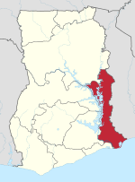 Location of Volta in Ghana | |
| Country | Ghana |
| Capital | Ho |
| Districts | 25 |
| Government | |
| • Regional Minister | Archibald Yao Letsa[1] |
| Area | |
| • Total | 20,570 km2 (7,940 sq mi) |
| Area rank | Ranked 5th |
| Population (2010 Census) | |
| • Total | 2,118,252 |
| • Rank | Ranked 7th |
| • Density | 100/km2 (270/sq mi) |
| GDP (PPP) | |
| • Year | 2014 |
| • Per capita | $3,974 |
| GDP (Nominal) | |
| • Year | 2014 |
| • Per capita | $1,902 |
| Time zone | GMT |
| Area code(s) | 036 |
| ISO 3166 code | GH-TV |
| Website | http://voltaregion.gov.gh/ |
Volta Region (or Volta), is one of Ghana's ten administrative regions, with Ho designated as its capital. It is located west of Republic of Togo and to the east of Lake Volta. Divided into 25 administrative districts, the region is multi-ethnic and multilingual, including groups such as the Ewe, the Guan, and the Akan peoples. The Guan peoples include the Lolobi, Likpe, Akpafu, Buem, and Nkonya people, et al.
Districts of the Volta Region
.svg.png)
The region has 25 districts consisting of 5 municipal and 20 ordinary districts with all the administrative changes as of December 2012.[2]
Education
Universities
- University of Health and Allied Sciences
- Evangelical Presbyterian University College
- Volta University College
- Ho Technical University
Background
The Volta region was formed by the state union of the former British Togoland which was part of the German protectorate of Togoland. It was administered as part of the Gold Coast by the British and later renamed Trans-Volta Togoland.[3]
Togoland Congress
The Togoland Congress (TCP) was a political party formed in 1951 to campaign for the unification of the Ewe people in British Togoland and French Togoland as a separate Ewe state. The party was defeated in the May 1956 UN plebiscite in British Togoland, which resulted in the unification of British Trans-Volta Togoland with Gold Coast, which later became independent as Ghana.[4]
On 9 May 1956, a vote was conducted to decide the future disposition of British Trans-Volta Togoland and French Togoland. The native and dominant ethnic group, the Ewe people, were divided between the two Togos. 58% of British Trans-Volta Togoland inhabitants voted in favor of state union with the Gold Coast, and the Togo Ewe state was incorporated with Gold Coast.
There was vocal opposition to the incorporation of Togoland into modern Ghana, from the Ewe people who voted (42%) against in British Togoland, as the Ewe wanted the unification of the Ewe people in British Togoland and French Togoland as a separate Ewe state (modern Togo).[5]
Demographics
The native and largest ethnic group of the Volta Region (Togoland / British Togoland) are the Ewe people (68.5% of the population). They consist of several sub groups such as the Anlo Ewe, Tongu Ewe, Wedome and Avenor Ewe. Other ethnicities include the Guan people (forming 9.2% of the population), the Akan people (8.5%), and the Gurma people (6.5% of the population).[6]
Other Districts
The Todzie (not to be confused with Oti Region), is the given name for the regional division that some citizens are advocating to be carved out from the Volta Region, as a separate region. The proposed Todzie Region occupies the entire southern part of Volta Region and was formerly part of the Gold Coast since 1850. According to some Voltarians, if the new region is approved by the government, Keta will be designated as the capital.
Districts in Oti Region
Oti Region is currently made up of seven districts. There are presently eight ordinary districts within the proposed Oti Region without any known municipal districts.
| District | Capital | District Chief Executive |
|---|---|---|
| Biakoye District | Nkonya Ahenkro | Louis Nana Akattah |
| Jasikan District | Jasikan | Nana Barima Kumessy-Bonsy II |
| Kadjebi District | Kadjebi | Seth Alifui |
| Krachi East District | Dambai | Rapheal Kofi Ogyemoko |
| Krachi Nchumuru District | Chindiri | Solomon Kuyon |
| Krachi West District | Kete Krachi | Kwame Ponye |
| Nkwanta North District | Kpassa | Paul Levin Gyato |
| Nkwanta South District | Nkwanta | Joseph Nyofam Ninkab |
Districts in Todzie Region
There are a total of 8 district administrative divisions within the presumed Todzie Region consisting of 2 municipal and 6 ordinary, as of December 2012.[7]
| District | Capital | District Chief Executive |
|---|---|---|
| Akatsi North District | Ave-Dakpa | James Gunu |
| Akatsi South District | Akatsi | Samuel Kwadzo Wuadi |
| Central Tongu District | Adidome | Mary Ama Agbenyenu |
| Keta Municipal | Keta | Sylvester Tornyeava |
| Ketu North District | Dzodze | Claver Kofi Lawson |
| Ketu South Municipal | Denu | Bernard Frank Amarble |
| South Tongu District | Sogakope | Samual Mawuko Eworyi |
| North Tongu District | Battor Dugame | Bubey Dzinadu |
Administration
The Volta region is run by a Regional Coordinating Council (RCC) and a District Assembly. The RCC is made up of the Volta Regional Minister who is the political head and his deputy as well as representatives of the Regional House of Chiefs, the District Chief Executives of the Volta region, the Presiding Members of the 12 Districts Assemblies and representatives of the various decentralized Ministries, Departments and Agencies in the Volta region. Each district is run by a District Assembly.[8]
Regional Commissioners and Ministers
- Francis Yao Asare
- Lieutenant Commander G.K. Amevor
- F.Q. Amegah
- Francis Agbley
- Modestus Ahiable
- Charles K. Agbenaza
- Kwasi Owusu-Yeboah, 2001 – 2005
- Kofi Dzamesi 2005 – 2009
- Joseph Amenowode, 2009 – 2012
- Henry Ford Kamel, 2012(Deceased)[9]
- Helen Ntoso, 2012- 2016
- Dr. Achibold Letsa, 2016 -
Constituencies
The Volta Region has 26 constituencies since the recent December 2012 parliamentary election,[10] increasing by 4 from the previous 22 which it had during the December 2004 parliamentary election and At the election in December 2000, there were 19 constituencies.
Tourism
The Tourism lco is Hon. Quentin G. S. K. Paawillee, from Tafi Agome, in the Volta Region of Ghana.
Recreation areas
- Museum
Mountains
Other Tourist Attractions
- Waterfalls
- Tafi Agome Caves
- Tafi Atome Monkey Sentery
- Wli Waterfalls
- Tagbo Falls
- Amedzofe Falls
- Biakpa Falls and Caves
- Kpoeta waterfalls (at Ho West District)
- Mount Afajato
- Mount Gemi
- Akpom Falls and limestone cave Logba Tota
- Snake Village Liate Wote
Famous native citizens
| Famous native citizens of Volta | |||||
|---|---|---|---|---|---|
| # | Citizen | Settlement | |||
| 1 | Erica Nego | Ho | |||
| 2 | Jerry Rawlings | Keta | |||
| 3 | Kofi Awoonor | Wheta | |||
| 4 | Peter Bossman | Ho | |||
| 5 | Ave Kludze | Hohoe | |||
| 6 | Fiifi Fiavi Kwetey | Nogokpo | |||
| 7 | Dzifa Ativor | Peki | |||
| 8 | Dr Ephraim Amu | Peki | |||
| 9 | Komla Dumor | Aflao | 10 | Quentin Gershon Paawillee | Tafi Agome |
References
- ↑ http://ghana.gov.gh/index.php/governance/regional-ministers
- ↑ "BREAK DOWN OF METROPOLITAN, MUNICIPAL AND DISTRICT ASSEMBLIES". GhanaDistricts.com. Archived from the original on 2012-12-12. Retrieved 2012-12-22.
- ↑ Beigbeder, Yves (1 January 1994). International monitoring of plebiscites, referenda and national elections - Self-determination and Transition to Democracy. Dordrecht: Martinus Nijhoff Publishers. p. 131 of 340. ISBN 978-0-7923-2563-5. Retrieved 2009-11-24.
- ↑ Daniel Miles McFarland, Historical Dictionary of Ghana, 1985, p. 173
- ↑ McLaughlin & Owusu-Ansah (1994), "The Politics of the Independence Movements".
- ↑ "Volta". Government of Ghana. Retrieved 2015-05-03.
- ↑ "BREAK DOWN OF METROPOLITAN, MUNICIPAL AND DISTRICT ASSEMBLIES". GhanaDistricts.com. Archived from the original on 2012-12-12. Retrieved 2012-12-22.
- ↑ "Volta Region - political administration". Retrieved 2009-11-24.
- ↑ "Volta Regional Minister, Henry Ford Kamel, is dead. myjoyonline.com".
- ↑ 2012 parliamentary election. myjoyonline.com.
External links
- Tourism – Volta Region
- Volta Region from statoids.com
- Volta Region – Districts
Places adjacent to Volta Region | |
|---|---|
| Municipal |
| |
|---|---|---|
| District |
| |